August Storms
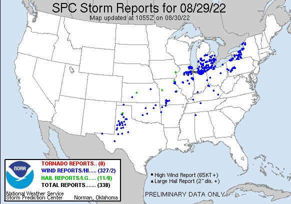 One thing lacking the past few years in our area is the lack of storms and significant lake effect snow. We had two intense storms this year which caused power outages and damage in the Otsego/Plainwell area. The first was August 3rd and the second was August 29th, the 29th storm being the most damaging. The south side of our road saw multiple tree tops sheared off while my side only lost a few small branches. The woods in my backyard and the neighbors on the north side saw little or no damage. My neighbor across the street had her power mast torn from her house and some roof damage to contend with as did the neighbors a couple of houses down. This was the theme over much of Otsego and Plainwell with multiple power lines down and damaged roofs and smashed cars from trees falling down upon them. A lot of people in this area got new shingles and underlayment. The roofing companies made a killing this year.
The August 3rd storm was similar with slightly less damage and power outages around the area. We lost power around 4:30 pm in wind-driven rain and small hail. The wind was in the 50 mph range. We had 2.70 inches of rain in an hour which caused a lot of street flooding around town. Our power came back on around 9 pm. The silly thing was I had just commented to my wife about how we shouldn’t lose power because of the good job the tree crews have done through our area to keep the lines free, within seconds the power went out, should learn to keep my mouth shut. Our neighbor’s car had a tree fall across it breaking the skylight and putting a long crease across the top.
February 3rd was our biggest early-year storm for 2022 when 8 inches fell. November brought 24 inches of snow between the 15th to the 19th. Our so-called blizzard of the 24th and 25th only brought 11 inches of light snow to Otsego. Our total snowfall for 2022 in Otsego was 91.7 inches. February 4th was our coldest low at -2° and our highest temperature was 90° on June 21st.
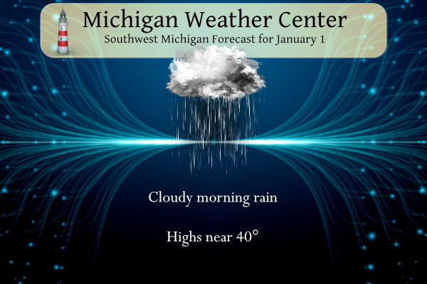
We are beginning 2023 with rain, not snow. The temperature here is 36° at 6 am. Yesterday’s high was 39° and the low was 31.5°.
A mix of light rain or snow will move across parts of Lower Michigan this morning. A thin coating of snow is possible north of M-46 as temperatures will be close to the freezing mark. The precipitation will end around noon, leaving cloudy skies. Expect relatively mild temperatures to start 2023, and a high chance of rain late Monday into early Tuesday.
Grand Rapids Forecast
7-Day Forecast 42.96°N 85.67°W grr 1 1Lansing Forecast
7-Day Forecast 42.75°N 84.53°W lan 1 1Kalamazoo Forecast
7-Day Forecast 42.24°N 85.65°W kzo 1 1Forecast Discussion
-- Precipitation Today --

The biggest question this morning is what kind of precipitation
will move through Michigan. Currently a precipitation shield is
moving through north of the I 96 corridor and will continue to
stream northward with a bigger swath infiltrating into southwest
Michigan from the southwest. Current observations has snow as the
main precipitation type along that band, however at LDM it seems
to be unknown, which given the temperature and dewpoint is
potentially freezing rain. Dewpoints along the I 94 corridor are
above freezing so any precipitation that moves into there will
be rain. Dewpoints from Lansing to Grand Rapids to Muskegon are
at 30F. This will complicate matters as latest soundings have a
unsaturated Dendritic growth zone. This means lack of ice crystals
so the precipitation will fall and freeze on surfaces instead of
generating snow. Current light winds will only aid this process.
Also is the fact that there is an inversion aloft, though its
strength varies. So a brief period of freezing rain/drizzle is
possible from now until 15Z along the I 96 corridor and will move
northward as temperatures warm by mid morning.

The precipitation which is due to a negatively tilted short wave
will lift through the region by noon. Temperatures will warm to
the low 40s though the trapped low level moisture only aided by
any precipitation will allow for patchy fog and low clouds to
persist through today.


-- Heavy rainshowers and a warm up Monday night into Tuesday--

The next forecast concern will be trek of a large upper level low
that will be moving through the Great Plains Monday and through
the Great Lakes states Monday night through Tuesday.
 Anomalous warm air advection will advance ahead of this system
which will catapult Max temperatures into the 60s by Tuesday.
Don`t pull out the board short just yet however, as any warm air
that advects into the region Tuesday will be followed by colder
air Wednesday and Thursday.
 The PWATS for this system remain anomalous with values upwards
of 1.5. This continues to show copious amounts of moisture to be
available. There will allow be a 45 to 50kt low level jet at
850mb moving into the region with this system around 18Z Tuesday.
Couple this jet with an increase of CAPE and increased 850mb LI`s
and you have a recipe for January thunderstorms. So we have
included a chance for thunder in the far Southeast though given
the trend there is a possibility that this chance could become
larger. Current QPF for Monday to Tuseday`s system is around a
half an inch to the north and around an inch along and south of
the I 94 corridor. However, given the above factors and the
convective nature of this system higher amounts are possible,
especially in downpours in thunderstorms. As the mid level low
moves through Tuesday into Wednesday a low level jet noses into
the region which could allow for any convection to linger Tuesday
evening.

-- Transition back to cold weather next weekend --

The question on many peoples mind is; when will it get cold again?
Well the trend looks better late this week and into next weekend.
850mb temperatures will drop below freezing around 18Z Wednesday
and will remain there through next weekend. The cold temperatures
coupled with lingering moisture into that system could allow for
snow showers Wednesday. Dry colder air through the mid level with
clear skies will only aid the cold air advection into next
weekend. Temperatures will drop back down to normal.
Get ready>>>>lows in the teens next week! Incredible!
Really??? Where??
https://weather.com/weather/tenday/l/b523690bfd952b86fef3627c919dd9855281a8da16b83c10bdd381c64ae12cbc
And what about the highs?
There is a change of lows near 20 for next week. But that would be close to average.
Slim
Snow county baby!
The GR NWS has state of the art equipment and has been reporting accurate data for years! Keep up the good work!
The cooler reading at GRR may have more to do with the location and terrain of the sensors and not the accuracy of the readings. I would think that all locations should have start of the art equipment.
Slim
Any idea why Holland had temps in the upper 60’s the other day? At one point it was 67 there but never got higher than 58 here. Faulty state of the art equipment?
Lasted quite a few hours:
https://w1.weather.gov/data/obhistory/KBIV.html
I am not sure what happened. Holland was a good 10° warmer than Muskegon to the north and South Haven to the south. When I get a chance I will drop a line to the NWS to see if they have a reason for that. Maybe some brough the sensor inside.
Slim
Less snow on the ground to help keep the temps down? Just a guess.
It has been pointed out by Mookie that for some reason, Grand Rapids has been cooler compared to average to several locations and that seems to be the case since the updated 30 year average came out. In looking at 3 locations that are on or near the 43rd parallel in Michigan. Here are the mean temperature for 2022 the current 30 year mean and the departure for Grand Rapids, Ionia and Flint. The 2022 mean at Grand Rapids is 48.7 the 60 year mean is 49.3 for a departure of -0.6° At Flint the 2022 mean is 48.4 (note… Read more »
The updated CPC outlook for January looks wet and warmer than average.
https://www.cpc.ncep.noaa.gov/products/predictions/30day/
Remember even if the temperatures are above average it can still at times get cold enough for some snow or worse freezing rain. But the over all temperature out look hints at a mild mid winter.
Slim
Hello blowtorch! Bring on the 50’s and maybe 60?
Happy New Year 2023 everyone! Hope it’s fantastic for you all!
Happy 2023!!! Wishing you all great happiness and health for you and your loved ones.
Happy New Year everyone! Let’s hope this year is better than the last.
Here in my area the August 29 storm was the bigger of the two events that MV posted. There was a lot of lightning and rain but not as much wind.
Slim
Happy New Year!!! We have now turned the page and it is now 2023. At Grand Rapids the annual mean temperature for last year was 48.7° the 30 year mean at GRR is 49.3° there was a total of 37.73” of rain/melted snow that is below the average of 39.40” At Muskegon the mean for 2022 was 50.1 the 30 year mean is 49.4 there and they recorded 32.58” of precipitation that is below the average of 35.08. At Lansing the 2022 mean temperature there was 49.9 the 30 year mean there is 48.6. For yesterday the official H/L at… Read more »
Wow GR temps are so off! I’m glad I exclude them.