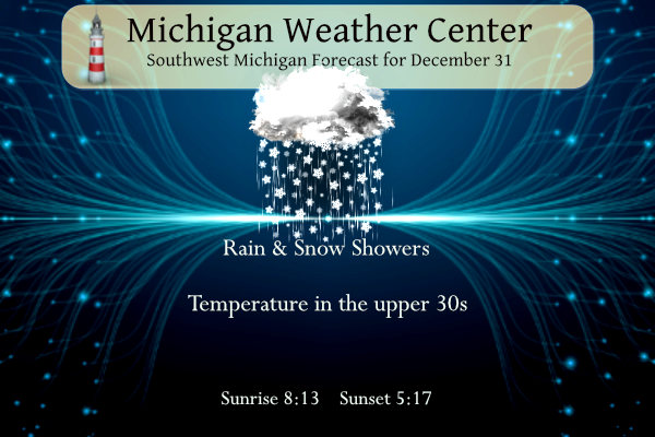
We end another year with record or near-record warmth and a snow deficit. We had 35.7 inches of snow for the year in Otsego and 34.33 inches of rain (as of 12 am this morning.) The snowfall total since the end of October is only 9.5 inches. There is talk of models depicting a flip to more winterlike conditions mid-month in January (we shall see if that pans out). Snow showers mixed with rain will have little impact on travel today since temperatures will be in the mid to upper 30s. Watch for slick spots developing tonight though as temperatures dip below freezing.
Forecast
Weather History
1875: The year ends on a remarkably balmy note. At Lansing, the high temperature of 70 degrees is the highest ever recorded in the month of December.
1976: One of the coldest Decembers on record ends with a second consecutive day of record lows across Lower Michigan. The temperature falls to 15 below zero at Muskegon, a record low for the date and for the entire month of December.
On December 31, 2015, the high temperature reached 36, 34, and 33 in Detroit, Flint, and Saginaw respectively. Although typical for December, they were chilly compared to the rest of the month. Fueled by a particularly strong El Nino and a northward displacement of the polar jet stream, the monthly average temperature for December 2015 came out to 41.1, 40.0, and 39.1 degrees, making it the warmest December on record for all SE Michigan climate sites.
Also on December 31, 1974, this marks the end of the snowiest December on record in Detroit. A total of 34.9″ of snowfall fell during the month, which is 23.8″ above average!
1876: A heavy snowstorm hit southern Arkansas, with amounts well over 20 inches in places. 28 inches was reported near Warren, and 24–28 inches was reported at Arkansas City.
1882: Downtown San Francisco saw 3.5 inches of snow.
Click HERE for more information from thestormking.com
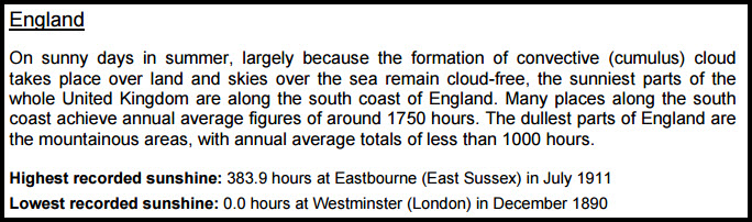
1890: According to the National Meteorological Library and Archive from the United Kingdom, during December 1890, Westminster, England saw zero hours of sunshine. Click HERE to read a pdf with more Weather Extremes from the National Meteorological Library and Archive.
1933: During the last week of December, a series of winter storms pounded the mountainside with 12 inches of rain near Los Angeles. More rain occurred on New Year’s Eve, including 4.86 inches in downtown Los Angeles. The 4.86 inches is currently the fourth most rainfall to occur in one day in downtown Los Angeles since 1877. Around midnight, hillsides in at least three mountain locations collapsed sending millions of tons of mud and debris into the Crescenta Valley neighborhoods below. Crescenta Valley is a few miles north of Los Angeles. This mudslide destroyed more than 400 homes. Following the disaster, the U.S. Army Corps of Engineers and the County of Los Angeles built a flood control system of catch basins, and concrete storm drains, designed to prevent a repeat of the 1934 disaster. The Historical Society of the Crescenta Valley has a few “Then and Now” photos from this event.

View north from Mayfield Avenue showing a covered section in the foreground to be used as a street crossing. Crane from the mixer moves concrete for the wall sections to the top of the walls. The image is courtesy of the National Archives and Records Administration.
1967: The kickoff temperature for the NFL Championship Game between the Dallas Cowboys and the Green Bay Packers was -13°F with a wind chill of -36°F. This game is known as the “Ice Bowl.” Click HERE for more information from NWS Green Bay.
2000: The “Snow Bowl” was played between Mississippi St and Texas A&M at Independence Stadium in Shreveport, Louisiana. Snow began about a half hour before kickoff and didn’t stop until well after the bowl game.
On this day in 2000- The Snow Bowl.
Miss. State 43
Texas A&M 41 pic.twitter.com/C2DiDBABx5— The Flying M ™️ (@MSUhistory) January 1, 2018
Forecast Discussion
Low pressure will pass through Lower Michigan today. Drizzle is
developing this morning as moisture and lift increases in a layer
of low clouds that is warmer than -8C and mostly ice-free. The
temperature in most locations has stayed above 32 and this will
limit the chance of freezing drizzle, though areas near and north
of Big Rapids are most at risk of a little freezing precip around
daybreak.

With inversion heights and rising toward the bottom of the DGZ
during the day, precip will transition toward snow sometimes
mixing with rain. Forecast soundings don`t seem ambitious about
keeping the DGZ saturated above the inversion, and most of the
lift will be focused beneath the DGZ. The result should be
transient and nonuniform patches of slightly heavier precip rates
interspersed between breaks in the precip. QPF is in the range of
0.05 to 0.10 inches with isolated 0.20 through tonight.
Temperatures in the mid 30s much of the day should limit impacts,
though may have to monitor for some minor impacts this evening as
temperatures cool. Patchy slick spots may also be present
overnight with temperatures dropping into the 20s.

The main emphasis Tuesday will be on the breezy conditions
preceding a shortwave and cold front approaching from the
northwest. Winds are expected to gust to 30-35 mph out of the
southwest, probably strongest around BIV and GRR. Otherwise dry
weather is expected Tuesday with increasing cloudiness.

As upper troughing briefly digs/dips southward into the GrtLks
Rgn on Wednesday and Wednesday night and H8 temps lower to -12C,
we can expect a period of lake effect snow showers. Winds are
initially west-northwest on Wednesday implying a decent coverage
of snow showers but then shift northerly on Wednesday night with
the passage of a sfc trough, restricting snow showers to the
coast. Since sfc temps on Wednesday will be in the mid to upper
30s, its doubtful we`ll see much impact/accumulation out of this
system.

Thursday and Friday are dry weather days with a surface ridge
passing through, then chance pops return for next weekend as a
wave in the srn stream moves east-northeast from the srn Plains.
While the latest 00Z deterministic GFS is suggesting that a couple
inches of snow is possible from this system, the majority of
ensemble members keeps the bulk of the QPF south of MI.

There is growing ensemble support for a more active/potentially
snowier pattern after about 9 January, with the possibility of a
notable synoptic system followed by colder air and lake effect.
Happy New Year, friends. Let’s hope 2024 is even better than 2023.
Another year, another string of warm weather delusion and wishcasting! WOW!
It’s not wishcasting when the weather actually is warmer than normal and zero snow all the way into January. That’s a WOW!!
How is this possible? I thought winter was cancelled this year! The teleconnectors are coming right in line! Who knew? Incredible!
NWS “Deterministic and ensemble guidance also continue to suggest the
potential for a snowier pattern near Jan 9-11. This would include
the potential for a larger synoptic system followed by cold air and
lake effect snow.”
Wait, so winter is not canceled? Something how that works out!
Who would have thought?
We sure have seen a lot of horrible weather lately! Temps in the upper 30’s with rain/drizzle! Definitely qualifies as lousy weather! Just the facts people!
Another year another string of wishcasts from the Cold Weather Crazies! Oh it’s going to be cold and snowy at the end of November, oops I mean cold and snowy at the end of December, oops I mean cold and snowy in mid January! But the FACTS are a beautiful snowless and warm winter with no end to the warmth in sight!!!
The officials found another way to hose the Lions! This has been happening for at least the last 30 yrs! Some things never change – is is like the warm weather fanatics keep distorting facts, wishing their life away because they don’t like snow, posting false information, distorting the truth, talking about being almost Spring ever before winter starts, never admitting we had a good snowstorm even after getting storm after storm last season, etc, etc, etc! WOW!
Yes, there is now snow on the ground in Michigan once again.
https://www.mtu.edu/webcams/view/
and more snow on the ground.
https://www.exploremunising.com/web-cams/
Slim
That is a start! Wait till mid month and then the fun begins!!
I wish everyone a Happy New Year, filled with a sufficient amount of joy to fuel our days, and resilience to bounce back from the curve balls that life inevitably throws at us!
While some have liked while others have not this winter has been a rather historic winter season so far. December will be the 2nd warmest on record for most locations and at Muskegon it will be the warmest. Depending on how much snowfall is recorded today it will be either the 2nd or 3rd least snowy December at Grand Rapids. And the least snowy start to any winter season. There has been just 3.2” of total snowfall this season so far at Grand Rapids and the most on the ground at 7AM so far this season is just a trace.
Slim
Wow, nice to be able to witness an historic start of Winter like this one! Almost half way through our snow plow contract and we’ve paid $0.00 so far. Nice way of keeping costs down!
Think of how much money MDOT and road commissions are saving in salt costs.
Very true. Although I can see them dumping 3 or four inches of salt on the next one inch of snow that falls. And then plowing all that salt into the ditch.
Seriously. The one time we got some flurries this season, I think every salt truck was out dumping tons of it.
The official H/L yesterday at Grand Rapids was 44/25. There was no rain/snow. The sun was out a reported 17% of the time. For today the official H/L is 33/21. The record high of 60 was in 1965 the winter of 1965/66 was also a strong El Nino winter. The lowest on this date was -14 in 1976. The wettest was 0.75” that fell as 8.2” of snow in 1957. The most snowfall of 9.7” was in 1957 the most on the ground was 13” in 2000. Last year the H/L was 38/32 and there was a trace of snowfall.
Slim