This spring has brought a lot of ants and ticks which I believe have been brought about by the dryer than normal conditions. After 17 years underground, more than a billion Brood X cicadas will emerge this spring across parts of the United States. Dryer than normal conditions will hopefully keep the mosquito populations in check. The past few years those little buggers have been horrible. Over the past couple of years, I have noticed a lot more walking sticks and katydids. So, I guess this is my bug report for the month… 😆
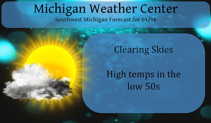
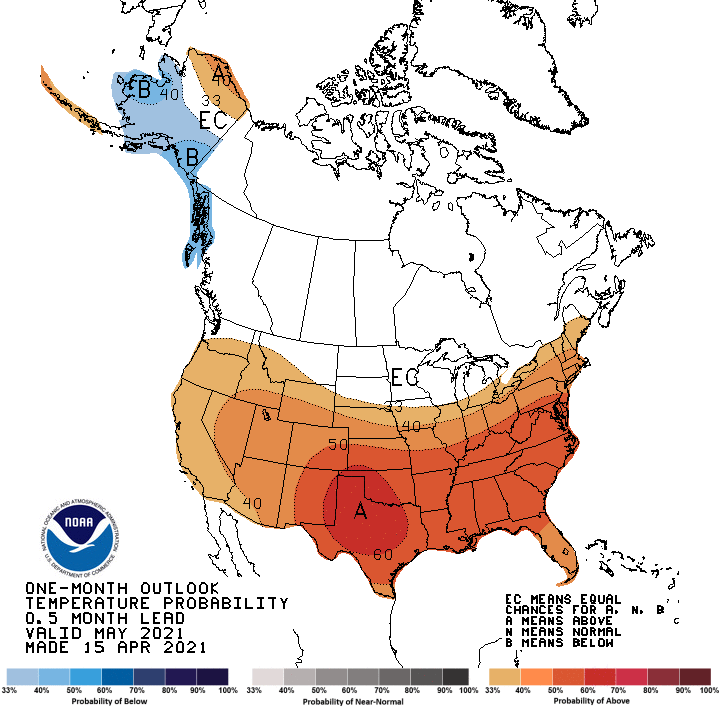
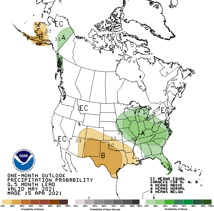
We will remain dry right on through the weekend with our next chance of precip coming Monday night. The latest from the CPC gives us better chances of rain for May with chances of above-normal temps for the southern lower.
[columns] [span6]
[/span6][span6]
[/span6][/columns]
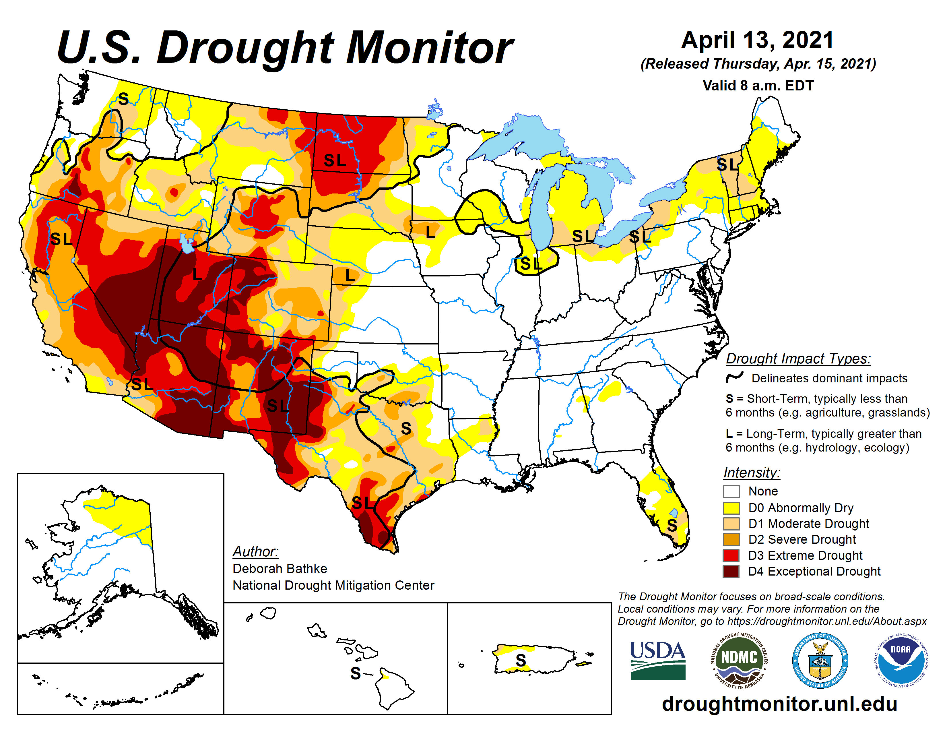
Conditions in most of Michigan remain dryer than normal as is a good portion of the U.S.. I am thinking we should see some improvement in our state as we get further into spring.
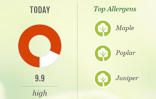
… and finally, pollens will be on the uptick today through the weekend,,,
Forecast Discussion
-- Mostly dry weekend with just a small chance of rain --

Today will be the transition period between the cool and unsettled
weather of the past few days, to a period of more mild and drier
weather. The upper low that has been sitting over the area will
rotate east, and start to allow the ridge of high pressure to our
west to build in.

This area of high pressure will bring a calm and cool night to all
of the area. Normally with the expected temperatures in the lower
30s for most, we would be issuing a frost advisory. As has been
mentioned many times, local agricultural experts advise that
impacts will not happen until temps get down into the 20s for the
areas where fruit trees are starting to bud out. The normally colder
area of interior Central Lower will likely get down into the upper
20s, but there are not really any fruit trees up there.

We have been watching for the potential of a few afternoon showers
on both Saturday and Sunday for the eastern half of the area. The
gradually trend over the last couple of days has been for less and
less shower activity. The upper wave has trended toward weaker over
the area, with the bulk of the energy going south of the state. The
timing on the Sunday wave has been slower, so any kind of kick the
wave might have, will come after peak heating so not much
instability to work with.

-- Rain and snow the first half of next week with much cooler temps--

Much of Monday should be dry, with a chance of rain arriving late in
the day across the NW counties toward Ludington. The precipitation
initially in the form of rain, will only slowly drop SE through
Tuesday afternoon. This is because the cold front will become
parallel with the upper flow and will slow down.

As the colder air starts to arrive behind the front, the air will
become cold enough for some precipitation to start changing over to
some snow the further NW you go. It is at this point more
uncertainty exists in the details of the forecast. The uncertainty
exists with where the front stalls out, waves of low pressure that
ride along the front, and what p-type and how much of each type
falls.

There is some potential that if the ingredients line up right, some
accumulating snow will be possible. This far out however, it is
quite difficult to pin down any of those types of details at this
point. The only thing that we have a fair amount of confidence with,
is that it will likely precipitate at some point with cooler
temperatures.

-- Moderating temps later next week with dry conditions returning --

We will eventually see the upper trough that will help to drive the
precipitation for the late Mon-Wed time frame push east of the area.
At this time, it looks like it should do so by Thursday. Once it
clears, the amplified pattern would support a more amplified ridge
building in, and moderating our temperatures and drying the area out
a bit.
Spectacular day today. Just returned from taking the dog for a long walk. So many people outside enjoying the sunshine.
Great poool Weather hu mooikee….Lol…. Possible snowstorm next week who knew?? Have a super weekend INDY
+1000
A good article about the incredible April cold! Wow!
https://www.accuweather.com/en/winter-weather/damaging-freezes-to-hit-central-us-as-cold-pattern-lingers/932694
Get prepared for more normal temps over the next two weeks!
https://www.accuweather.com/en/us/rockford/49341/daily-weather-forecast/2211654
There are indications that the next 2 weeks or more will be on the cooler side of average.
https://www.cpc.ncep.noaa.gov/products/people/mchen/CFSv2FCST/weekly/
A few days next week could be well below average. The NWS forecast high of around 40 next Tuesday would be 40 degrees below the average high of 60.
https://forecast.weather.gov/MapClick.php?x=149&y=157&site=grr&zmx=&zmy=&map_x=149&map_y=157#.YHm49ehKg2w
So we shall see.
Slim
With cloudy skies the overnight low here was held up to 39. Here is part of todays GRR NWS discussion. ” THIS AREA OF HIGH PRESSURE WILL BRING A CALM AND COOL NIGHT TO ALL OF THE AREA. NORMALLY WITH THE EXPECTED TEMPERATURES IN THE LOWER 30S FOR MOST, WE WOULD BE ISSUING A FROST ADVISORY. AS HAS BEEN MENTIONED MANY TIMES, LOCAL AGRICULTURAL EXPERTS ADVISE THAT IMPACTS WILL NOT HAPPEN UNTIL TEMPS GET DOWN INTO THE 20S FOR THE AREAS WHERE FRUIT TREES ARE STARTING TO BUD OUT. THE NORMALLY COLDER AREA OF INTERIOR CENTRAL LOWER WILL LIKELY GET… Read more »
Incredible cold is set for the rest of this month! Wow!
https://weather.com/weather/tenday/l/b4ea0280869baa46799dc75eacef8904785ec43ad2f6fb098355fbc208a55e2c
We’ve had a ridiculous number of stink bugs in and around our garage since last fall. Usually they disappear fora while during the Winter, but with the crazy mild one we had this year they never went away.
Looks like they come inside for the winter.
https://www.clickondetroit.com/news/2018/04/09/michigans-stink-bug-season-could-be-worse-than-last-year-experts-say/
As according to the GRR NWS there are no fruit trees to the NE of GR they may not have a issue with stink bugs.
Slim
Get prepared now!
https://www.pivotalweather.com/model.php?m=gfs&p=sn10_acc&rh=2021041600&fh=384&r=conus&dpdt=&mc=
For what??? Temps in the 50’s??
https://weather.com/weather/tenday/l/b4ea0280869baa46799dc75eacef8904785ec43ad2f6fb098355fbc208a55e2c