Who would have thought the Lions would be 13 and 6 this year. They play Tampa Bay at 3 pm today on NBC and the Lions are six-point favorites to win. They beat the Bucs 20 to 6 during the regular season. GO LIONS!
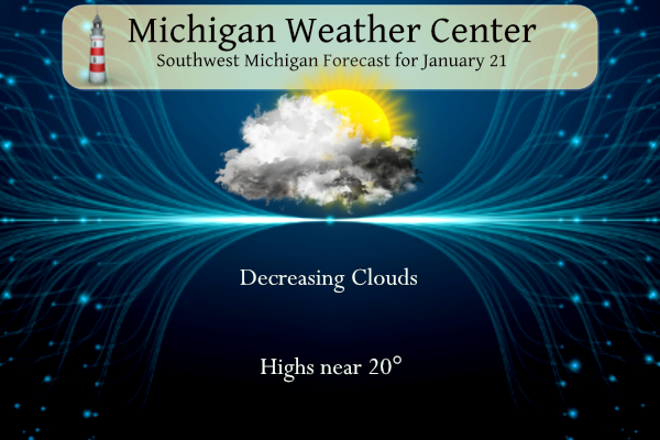
We will have a dry Sunday with some sunshine, a wintry mix of snow, sleet, and freezing rain is likely Monday into Tuesday. There could be some accumulations of ice Tuesday morning, mainly south of I-96. Mostly snow is forecast north of I-96 with 1-3″ possible. A midweek warmup is anticipated with precipitation changing to all rain by Wednesday.
Forecast
Weather History
1984: The temperature hits a record low of 15 below zero at Grand Rapids for the second consecutive day. The temperature at Lansing only manages to reach zero degrees during the day.
On January 21, 1984, the overnight temperature dropped to -21 degrees in Detroit! This is the second-lowest overnight temperature ever recorded for the city of Detroit.
U.S.A and Global Events for January 21st:
1963: Up to 3″ of snow falls on San Francisco, their heaviest since 1887.
1985: Jacksonville, Florida, recorded its all-time record low of 7 degrees. Macon, Georgia, had its coldest day ever with a temperature of 6 degrees. It was the coldest Inauguration day in history as President Reagan is sworn in for a second term during cold and winds that resulted in wind chill readings of 30 degrees below zero. Because of the bitter cold temperatures, many outdoor Inauguration events were canceled, and President Reagan was sworn in the Capitol Rotunda.

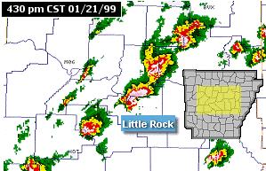
1999: A major tornado outbreak occurred from the southwest into central and northeast Arkansas during the afternoon and evening. In the Little Rock Area, 30 tornadoes tracked across 15 counties. Homes and businesses were damaged or destroyed in Little Rock, Beebe, McRae, and areas farther north and east. Eight deaths resulted from the tornadoes, with 140 to 150 injuries also reported. Click HERE for more information from the National Weather Service office in Little Rock, Arkansas.
Forecast Discussion
- Dry today. Snow and Mixed Precipitation Arrives Monday.

Latest radar imagery shows snow showers continuing to diminish.
We also see on IR imagery that the western edge of the clouds
over the lake continue to move east. Ridging over the western
Ohio Valley will continue to erode the clouds and we`ll likely
see some sunshine today. It will be short lived, though. Another
area of low pressure over Texas will move northeast today and
spread a mixture of snow/sleet/freezing rain/rain across the cwa
beginning Monday morning with much of the accumulations
occurring after Monday afternoon.

Slippery travel is certainly possible by Monday afternoon as
snow turns to a mix of sleet and freezing rain south of I-96.
Snow accumulations around a half inch are possible by late in
the day along the I-96 corridor with less south.

Moist southerly flow from the Gulf continues Monday night into
Tuesday. The bulk of the QPF with our next winter weather event
occurs late Monday night and Tuesday as srn Plains shortwave
ejecting northeast from base of the longwave trough is passing
through. The Tuesday commutes may be impacted.

Above freezing warm nose aloft pushes in toward I-94, and possibly
as far north as I-96 for a time, while below freezing sfc air is
slow to dislodge creating a freezing rain and sleet threat. Roads
temps will be slow to recover due to recent lengthy period of cold
weather so some icing will probably linger for a time where freezing
rain occurs even as air temps rise above freezing. Mostly snow is
expected for areas near/north of I-96.

Latest model trend is for less northern extent of the freezing and
sleet, favoring mostly snow north of a BIV to LAN line including
GRR.  QPF is around 0.5" for this event, and we could be looking at
a few inches wet/low ratio snow within deformation zone/pivot point.
Freezing rain amounts in the vicinity of I-94 do not look to exceed
a tenth of inch at this time.

- Midweek Warm-up with Rain and Fog

The next wave coming through midweek looks to feature all rain as H8
temps surge above 5C and high temps reach/exceed 40F. QPF is not
excessive and would not anticipate any flooding concerns as the snow
pack absorbs the rain. One concern however will be the slippery
conditions created by rain falling on snowpacked roads. This could
be problematic for travel especially in rural areas. The other
potential issue will be areas of fog as dew points rise into the mid
to upr 30s over the snowpack.
Way to go Lions! NFC Championship against the Niners. I can’t believe it.
Now that I agree with! I am having a hard time believing the Lions are one game away from the Super Bowl!
15 days in a row with SNOW! Get ready for more snow and a WWA for Monday afternoon/evening! WOW, just wow, WOW!!!!
Been a GREAT weekend to get outside and enjoy the perfect winter sports conditions! In fact this has been one of the best 10 day stretches of winter weather in a long time! Just this week, I have been snowshoeing 3 times, cross country skiing 2 times and downhill skiing 2 times! All of this while some people have been hibernating inside complaining about cold and snow! Absolutely incredible! I love winter!
After this slushy storm, it looks like we are going to have a stretch of mild weather and warm (for the time of year) temps. I was enjoying the cold and snow, we have 12” on the ground. And all that will turn to mud. And mud season is the worst. I hope it’s not a 3 month mud season.
Go Lions!! Been a great weekend to stay inside, stay warm and comfortable and watch football!
GO LIONS!!!! The official H/L yesterday at Grand Rapids was 24/2 there was 0.2” of snowfall. There now has been 15 days in a row of at least a trace of snowfall at GRR. There is 11” on the ground at GRR and 13” here in my yard. There was 34% of possible sunshine. For today the average H/L is 30/18 the record high of 61 was set in 1906 and 2017. The record low of -15 was set in 1984. The most snowfall of 6.1” fell in 1963 the most snow on the ground was 22” in 1963. Last… Read more »
I hope the magic continues. The Bucs have been red hot the 2nd half of this season.
Let’s Go Lions!