Whoa! The Lions are off to the NFC Championship game! They are fun to watch this season and actually look like professionals. Will they go to the Super Bowl this year? We shall see. GO LIONS!!!
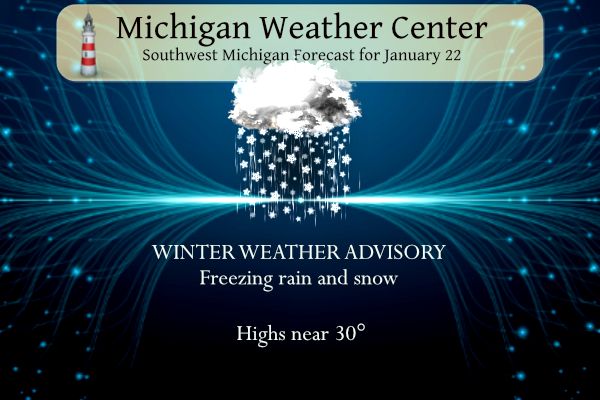
We have several winter weather advisories for southern Michigan:
Muskegon-Montcalm-Gratiot-Ottawa-Kent-Ionia-Clinton-
Including the cities of Muskegon, Greenville, Alma, Grand Haven,
Jenison, Grand Rapids, Ionia, and St. Johns
323 AM EST Mon Jan 22 2024

...WINTER WEATHER ADVISORY IN EFFECT FROM 1 AM TO 4 PM EST
TUESDAY...

* WHAT...Mixed precipitation expected. Total snow accumulations
  of up to one inch and ice accumulations of up to one tenth of
  an inch.

* WHERE...Portions of central, south central, southwest and west
  central Michigan.

* WHEN...From 1 AM to 4 PM EST Tuesday.

* IMPACTS...Plan on slippery road conditions. The hazardous
  conditions could impact the morning commute.
Allegan-Barry-Eaton-Ingham-Van Buren-Kalamazoo-Calhoun-Jackson-
Including the cities of Holland, Hastings, Charlotte, Lansing,
South Haven, Kalamazoo, Battle Creek, and Jackson
323 AM EST Mon Jan 22 2024

...WINTER WEATHER ADVISORY IN EFFECT FROM 7 PM THIS EVENING TO
4 PM EST TUESDAY...

* WHAT...Mixed precipitation expected. Total snow accumulations
  of up to one inch and ice accumulations of one tenth to two
  tenths of an inch.

* WHERE...Portions of south central and southwest Michigan.

* WHEN...From 7 PM this evening to 4 PM EST Tuesday.

* IMPACTS...Plan on slippery road conditions. The hazardous
  conditions could impact the morning commute.
Elkhart-Lagrange-Steuben-Noble-De Kalb-Whitley-Allen IN-Miami-
Wabash-Huntington-Grant-Northern Kosciusko-Southern Kosciusko-
St. Joseph MI-Branch-Hillsdale-Williams-Fulton OH-Defiance-Henry-
Including the cities of Elkhart, Goshen, Nappanee, Lagrange,
Topeka, Shipshewana, Angola, Fremont, Kendallville, Ligonier,
Albion, Auburn, Garrett, Columbia City, Tri-Lakes, South Whitley,
Fort Wayne, New Haven, Peru, Grissom AFB, Mexico, Wabash,
North Manchester, Huntington, Roanoke, Marion, Gas City, Upland,
Syracuse, Milford, North Webster, Leesburg, Warsaw, Winona Lake,
Silver Lake, Mentone, Sturgis, Three Rivers, White Pigeon,
Mendon, Coldwater, Bronson, Hillsdale, Jonesville, Litchfield,
Bryan, Montpelier, Edgerton, Wauseon, Archbold, Swanton, Delta,
Defiance, Sherwood, Hicksville, Napoleon, Deshler,
and Liberty Center
442 AM EST Mon Jan 22 2024

...WINTER WEATHER ADVISORY REMAINS IN EFFECT FROM 7 PM THIS
EVENING TO 1 PM EST TUESDAY...

* WHAT...Freezing rain expected. Total ice accumulations of one
  tenth to a quarter of an inch. Ice accumulations in excess of a
  quarter of an inch possible.

* WHERE...Portions of northern Indiana, southwest Michigan and
  northwest Ohio.

* WHEN...From 7 PM Monday to 1 PM EST Tuesday.

* IMPACTS...Difficult travel conditions are possible. Hazardous
  travel is expected Tuesday morning.

* ADDITIONAL DETAILS...Ice accumulations in excess of a quarter
  of an inch are possible, especially northwest of a line from
  Monticello to Warsaw to Hillsdale.
Livingston-Oakland-Macomb-Washtenaw-Wayne-Lenawee-Monroe-
Including the cities of Howell, Pontiac, Warren, Ann Arbor,
Detroit, Adrian, and Monroe
410 AM EST Mon Jan 22 2024

...WINTER WEATHER ADVISORY IN EFFECT FROM 7 PM THIS EVENING TO
4 PM EST TUESDAY...

* WHAT...Mixed precipitation expected. Total snow accumulations
  of up to two inches and ice accumulations of one tenth to two
  tenths of an inch.

* WHERE...Livingston, Oakland, Macomb, Washtenaw, Wayne, Lenawee
  and Monroe Counties.

* WHEN...From 7 PM this evening to 4 PM EST Tuesday.

* IMPACTS... Hazardous travel. The hazardous conditions are
  expected to impact the morning commute.

* ADDITIONAL DETAILS... Light freezing rain or freezing drizzle
  develops by early evening and then increases intensity toward
  midnight. A mix of snow and sleet is possible at times across
  the area, although a greater mix is expected along and north
  of the M- 59 corridor. Primarily freezing rain occurs Tuesday
  morning until temperatures warm above freezing early to mid
  afternoon.
Forecast

A wintry mix is expected through Tuesday. The probability of freezing rain is highest along and south of the I-94 corridor while the probability of accumulating snow is highest north of I-96.
Weather History
1883: Bitter cold arctic air sends the temperature down to 14 below zero at Lansing and 8 below at Detroit. The high for the day at Lansing is 4 below zero, the coldest high temperature ever in the month of January there.
2005: A blizzard drops a foot of snow across southern Lower Michigan with strong winds creating drifts up to 4 feet deep.
On January 22, 2005, an extremely strong “Alberta Clipper” storm system moved through Southern Lower Michigan. This storm dropped 10 to 12 inches across most of the Thumb and Metro Detroit regions. Port Hope in Huron County received a whopping 15.5 inches of snow.
Also on January 22, 2012, the high temperature in Flint rose to only 10 degrees, tying the record minimum high temperature for the date.
U.S.A and Global Events for January 22nd:
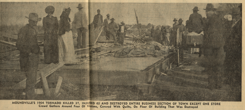
1904: An unusual estimated F4 tornado leveled the northern part of Moundville, Alabama, just after midnight, killing 37 people. The tornado reportedly had a phosphorescent glow. An engineer on a northbound Great Southern train saw the destruction right after it occurred and backed his train 12 miles in reverse to the town of Akron, where he sent a telegram for help. Click HERE for more information from the NWS Office in Birmingham, Alabama.
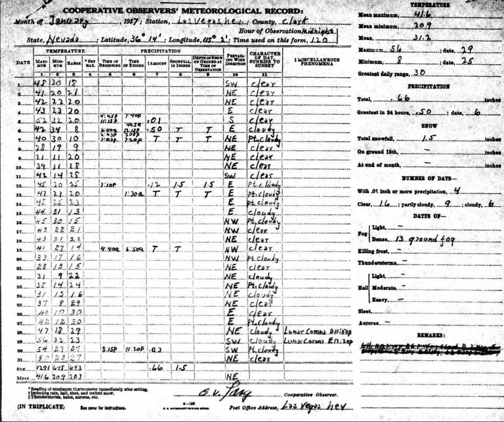
1937: Low of 9 degrees above zero in Las Vegas froze many pipes. Schools had trouble keeping warm, and coal was in short supply in the city. January 1937 was the coldest month on record for Las Vegas, with an average temperature of 31.2 degrees, 17.5 degrees below normal.
Forecast Discussion
-Light snow today, mixed snow/freezing rain tonight and Tuesday

We issued a Winter Weather Advisory for tonight for the southern
4 rows of counties. The I-94 segment begins at 00z and the I-96
segment begins at 06z. This advisory is for a mix of light snow
and freezing rain.

The forecast is progressing roughly on track. There have been
some minor tweaks to the snow and ice grids, but essentially,
the area of low pressure moving northeastward from the Red River
Valley is going to to spread two waves of precipitation across
the cwa. The first wave begins this morning over far southwest
Lower and will gradually overspread the cwa in the form of light
snow. That batch of snow will diminish by mid afternoon. It`s
possible, that there could be a little freezing drizzle on the
back end of the snow mainly over the southern two rows.

The second wave of precipitation will develop around 00z. The
HRRR/NAM 3KM show more in the way of freezing rain over the
southern cwa. However, if you dig into the model soundings,
you`ll see a temperature curve that hugs the 0 degree
line...even along I-94. The WRF ARW is similar. The FV3 Hi-Res
has the largest punch of warm air, but even its sounding isn`t
all that impressive. This tells me that even though we have
around a tenth of an inch of ice in the forecast over the
southern cwa, it might be overdone.

Given the uncertainty with regard to p-type, a Winter Weather
Advisory for mixed precipitation seems like the way to proceed.

The precipitation will turn to rain Tuesday, except over the
northern two rows of counties. Total snowfall along the US-10
corridor will be around 2 inches, perhaps a bit higher locally.
The Advisories over the southern four rows of counties will
continue until 21z Tuesday.

-Rain Wednesday into Thursday

The next wave that heads northeast from the base of the longwave
trough over the srn Plains midweek pulls up warmer air than the
Tuesday wave. As a result all rain is forecast for p-type Wed and
Thur with lows in the mid 30s and highs 40-45.

Currently the heaviest rain is shown to fall south of MI through the
Ohio Valley Rgn and the 50th percentile QPF is around one half inch
in srn Lwr MI. This should not cause any big flooding concerns
especially since the snow pack will be absorbing much of that rain
and snow melt will be only gradual given the expected temperatures.

Perhaps the bigger concern will be rain falling on still heavily
snow packed roads which could cause icy travel conditions,
especially in rural areas. Areas of fog are also possible Wed
into Thur considering that dew points in the mid to upr 30s will be
pushing in atop the snow cover.

-Above Normal Temps Expected Through the End of the Month

A slight cool down is shown toward the end of the week as heights
fall behind the departing wave however temps remain above normal.
Little or no precipitation is expected next weekend as surface
ridging appears to dominate.  Looking even farther ahead high
temperature forecasts stay above freezing for the remainder of the
month and there is a fairly strong signal in ensemble guidance for
even milder temperatures arriving the first week of February.
Nice SNOW map,
https://www.pivotalweather.com/model.php?m=ecmwf_full&p=sn10_acc-imp&rh=2024012212&fh=48
Seasonal snowfall approaching 35 inches and we still have at least 2 months of winter left! Keep it rocking! Last week was Heaven on Earth! Wow!!!!!!!!
Let it snow, let it snow, let it snow! Incredible!
Getting light rain at my house currently with a temp of 29. I have some minor icing on my garage lights. Roads are wet. Of bigger concern would be the snow packed dirt roads if we get more freezing drizzle/rain. They would become an ice rink.
Look at all the pretty colors!! Wow just WOW!!
Been raining lightly here. Roads are just wet, but it is only 30 here
Starting to get some wet cold rain drops here.
Wow!! After today temp really doesn’t go below freezing at all til Saturday! Melting in full effect!
Loving this from the GRR NWS!!
Looking even farther ahead high temperature forecasts stay above freezing for the remainder of the month and there is a fairly strong signal in ensemble guidance for even milder temperatures arriving the first week of February.
You mean a prolonged warm up like some of us have been saying for a while now – despite all the cold weather hype on here? Wow!
Exactly!!
Winter Weather Advisory aka Travelers Advisory.
Go Lions!
Great news>>>>>by the beginning week of February the teleconnectors are all trending towards more cold and snow! The last time I pointed this out the warm weather fanatics said I was wrong and bam then we saw a major acrid air outbreak and record breaking snow events! WOW, just wow, WOW!! Bring it!
100% false according to NWS GRR
Too funny, boy does that sound familiar! Incredible
January has well above average snowfall and we had nearly 2 weeks of perfect winter weather! I love it!
The good news: it’s now warm enough to get outside and recreate
The bad news: the snow is not very nice and is melting soon
Break out the ice choppers for the driveways and sidewalks, as we have the melt/refreeze on some nights this week (along with the rain to further compound the situation).
The official H/L yesterday was 22/14 there was a trace of snowfall and 11” of snow on the ground. The sun was out 66% of the possible time. For today the average H/L is 30/18 the record high of 56 was set in 1933 and the record low of -6 was set in 1970. The most snowfall of 12.3” fell in 1963 the most on the ground was 20” in 1979 and 1963. Last year the H/L was 34/29 and there was 0.5” of snowfall.
Slim
Rain, snow melt, above average temps for at least the next couple weeks? I love it!
What? Another WWA! Who would have thought?