Our strange El Nino winter will continue through the end of the month. Temperatures today will be in the mid-40s then fall back into the low 30s for tomorrow before bouncing back into the mid to upper 40s on Sunday. There is a slight chance of snow overnight tonight. Next Tuesday is the next system we are keeping our eyes on. The SPC is predicting the chance of severe weather for the extreme SW corner of the state.
NWS Forecast
Weather History
2000: Warm air surges into Lower Michigan with temperatures reaching the 60s. Grand Rapids sets a record high of 63 degrees and Muskegon hits 60 degrees.
On February 23, 2003, Port Huron received a foot of snow from a snowstorm that lasted from the 22nd – 23rd.
1887: The Central Bureau of Meteorology of Rome began receiving the first reports of a massive earthquake from northern Italy Observers. The estimated magnitude earthquake of 6-7 killed at least 600 people in southern France and northern Italy. Click HERE for more information from Geophysical Journal International.
1977: A rare February tornado touched down briefly in Mason City, Iowa, inflicting F1 damage on a home and injuring one person inside. This is the only known February tornado on record in Iowa.
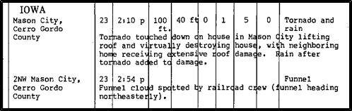
The image above is from Storm Data.
1995: Cyclone Bobby slams into the Western Australia coast, causing widespread flooding on February 23-24th, 1995. Some areas report up to 12 inches of rain from the storm.
Forecast Discussion
- Chance of snow late this afternoon and evening

Skies are clear over the cwa early this morning, but clouds over
Lake Superior are moving south. A cold front stretches from
Mackinac Island to northwest Wisconsin. Temperatures are
currently in the single digits north of it in southern Ontario
and this front will usher in much colder air to the region.

A sharp upper trough will accompany this front and likely cause
light snow to develop very late this afternoon into this evening
for the southwest portion of the cwa. There`s a strong shot of
cold air behind it as h8 temps fall from 0c this morning to -15c
by Saturday morning. Lake effect snow likely isn`t a player this
time due to the NNE winds behind the front. While there may be a
brief burst of snow with the front, accumulations will be
limited to a half inch or so in parts of Van Buren and Kalamazoo
counties.

Just as quickly as the cold air arrives, it moves out Saturday
with h8 temps warming to -4c by 00z Sunday.

We expected to see clearing skies late tonight as we get on
the- Low Confidence in Details for Wednesday Thursday back side
of the departing trough and then sunshine Saturday as upper
ridging noses into the region.

We`ll see highs around 40 today and around freezing Saturday.
Tonight will be cold with lows in the 10-15 range.


- Medium/High Confidence in rain moving in by Tuesday

Surface high moves east over the weekend with quickly moderating
temperatures in quasi-zonal flow regime, then we wait for moisture
return early next week ahead of the progressive western CONUS
longwave trough moving east.

Building warm advection pattern and area of isentropic lift with
rain breaking out by Tuesday afternoon and becoming widespread
Tuesday night. NBM categorical POPs appear justified given strong
 support for deep moisture and lift with upper level coupled
jet. At this point it appears highest QPF will be across southern
Lower Michigan where model soundings suggest enough instability for
deep convection.

- Low Confidence in Details for Wednesday Thursday

The 00Z ECMWF is more progressive with the longwave trough and
brings the cold front through Tuesday night while the GFS and GEM
have the fropa Wednesday afternoon. The ECMWF may be a fast outlier
or possibly hinting at a trend. Current NBM POPs linger through
Wednesday night and Thursday in the cold air, but it could be drying
out by that time.
Fun fact. This year is on track to be one of the warmest Februarys on record. Of the top ten warmest past Februarys March was colder than February 6 were not much warmer than February and only 1 was much warmer than February.
Slim
CPC looks like another blowtorch. I love 3 week winters and early springs!
This has certainly been a strange winter. W had the 2 week period of snow in mid-January… but otherwise it has essentially been snow-free. And it’s currently only February 23rd and it already feels like early spring. We have mostly 40s and 50s the next 2 weeks (a couple of 30s and 60s)… very typical of a late March or early April pattern
I think it was either Michael or Slim who pointed out the winter of 1931-32 was very similar to this one. I doubt we have the data that would show if that was a El Nino winter. Weather history is interesting.
The meteorological winter of 1931/32 is the current warmest at Grand Rapids the mean that meteorological winter was 33.9° the current mean this met winter so far is 33.3° We will have to see how warm it gets after this weekend. In 1932 March had the most snowfall and it was the coldest month of that winter.
Slim
The official H/L yesterday at Grand Rapids was 57/31 there was no rain/snowfall. The sun was out 60% of the possible time. For today the average H/L is 36/21 the record high of 63 was set in 1984 and 2000 the record low of -10 was set in 2015. The record rainfall of 1.48” fell in 1985 and the record snowfall of 5.4” fell in 1994. The most snow on the ground was 17” in 2014. Last year the H/L was 37/26 and there was a trace of snowfall.
Slim