
We have another warm fall day in store for SW Michigan with partly cloudy skies and temperatures in the mid-70s. It appears our warm weather will continue at least through the first week of October. The CPC outlook for October is guessing above-normal temperatures and below-normal chances of precipitation for the month.
Grand Rapids Forecast
9 24 grrU.S.A and Global Events for September 24th:
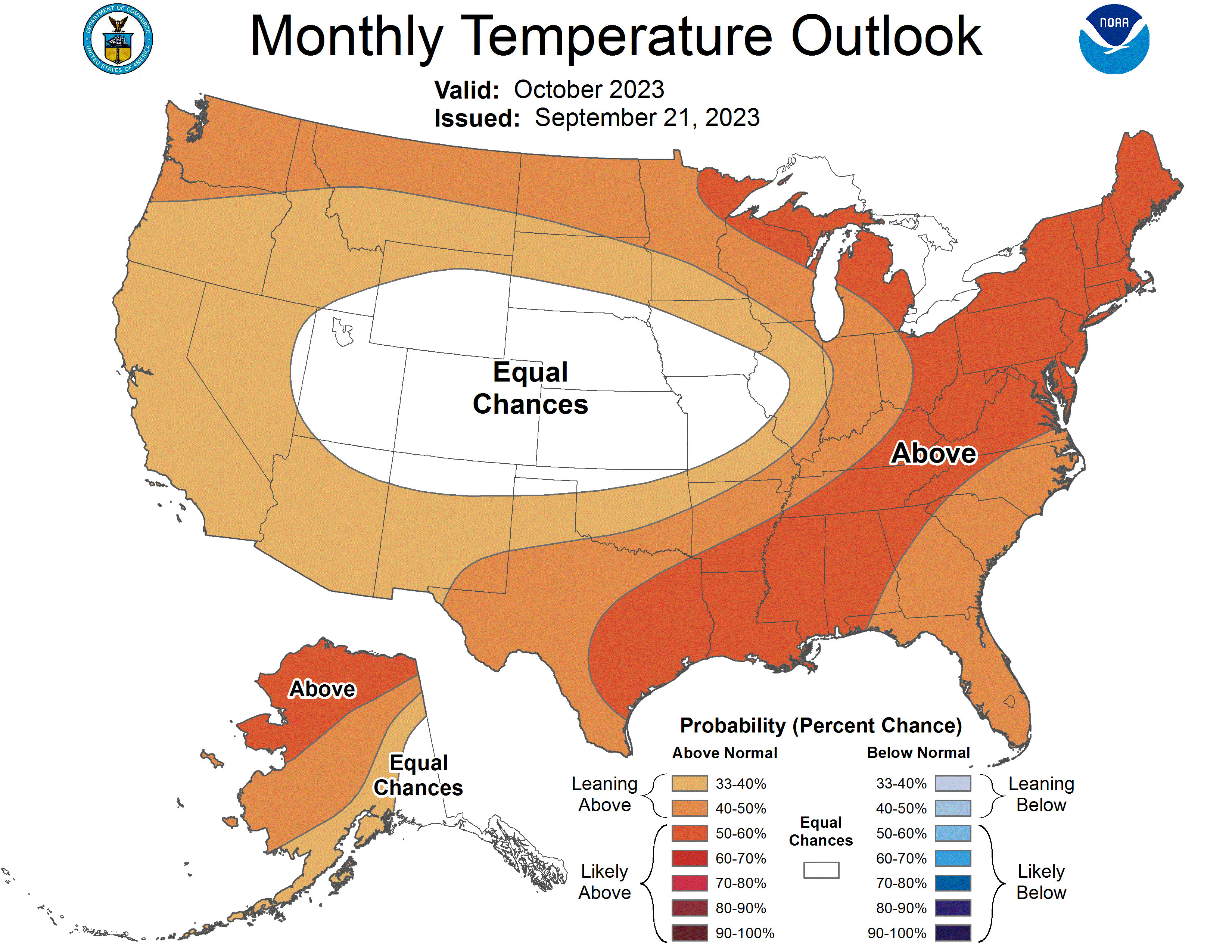
1926: The temperature at Yellowstone Park drops to 9 degrees below zero, making it the coldest September reading ever recorded in the US.
The image above is from the Climatological Data for Wyoming, September 1926.
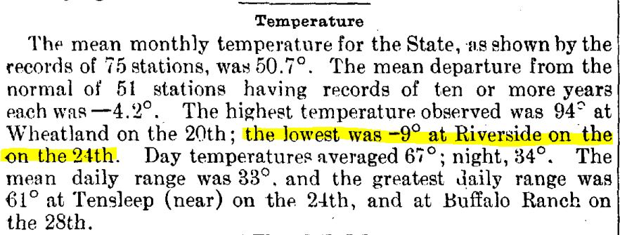
1939: A thunderstorm on this day dropped 6.45 inches in six hours at Indio, CA. This rainfall preceded “El Cordonazo” or “The Lash of St. Francis”, an actual tropical storm. For the entire storm, which started on this day and ended on the 26th, four inches of rain fell across the deserts and mountains as a dying tropical cyclone moved across Baja California into southwestern Arizona. This storm was the second tropical cyclone to impact California during this month. A strong El Niño may have contributed to the activity. The tropical storm produced 50 mph winds over the ocean and estimated seas of 40 feet. September rain records were set in Los Angeles with 5.66 inches and 11.6 inches at Mt. Wilson. 45 people died from sinking boats, and harbors were damaged. Total damage was estimated at $2 million. Californians were unprepared and were alerted to their vulnerability to tropical storms. In response, the weather bureau established a forecast office for Southern California, which began operations in February of 1940.
Track map of the 1939 California tropical storm. The image is courtesy of the National Weather Service Office in Los Angeles/Oxnard.
1956: Hurricane Flossy made landfall near Destin, Florida as a Category 1 storm. Click HERE for more information from the NWS Office in Mobile, Alabama.
1986: An F2 tornado, unusually strong for one in California, touched down just southeast of Vina on this day and traveled two miles through an agricultural area. A mobile home was destroyed, injuring a 22-year-old occupant. Eleven other buildings were damaged or demolished, and 50 acres of walnut orchards were flattened.
 Above is the Vina tornado as seen to the west from US 99. The image is courtesy of Storm Data.
2001: A weak, F0 tornado passed in the sight of the Washington Monument. Soon after, an F3 tornado struck College Park, Maryland.

2005: Early on the morning of September 24, 2005, Major Hurricane Rita came ashore near the Texas/Louisiana border. Click HERE for more information from the Hurricane Research Division. Click HERE for more information from the NWS Office in Lake Charles, Louisiana.
Forecast Discussion
Quiet weather continues today as surface high pressure centered
across SE Canada feeds dry air on easterly flow into Lower
Michigan. Model soundings show an increase in mid-level moisture
by Monday as weak shortwave troughing arrives in advance of an
upper low centered across Minnesota. There could be some isolated
showers by Monday afternoon, especially across the eastern
forecast area, but any QPF is expected to be light, generally a
few hundredths of an inch.

An upper low slowly moves southeast from Minnesota to Lower
Michigan bringing showers and isolated thunderstorms during the
middle of the week. Instability is marginal, but lapse rates are
steep enough to allow for a rumble of thunder Tuesday and
Wednesday. The low pairs with an upper high across SE Canada to
form a rex block, but this is transient as the low weakens and
moves east on Thursday to be replaced by longwave ridging by the
end of the week. The sensible weather will feature cooler, showery
weather being replaced by dry and warmer by next weekend.
Precipitation amounts during the Tuesday to Thursday period could
be a quarter to half an inch with the heavier amounts expected
across the southern half of Lower Michigan.
Seems we are back to a dry stretch (at least for me). Dry spring, wet July and first half of august, now dry since late aug/September. And it looks to remain dry for as far as I can see. I hope there is a large pattern shift soon.
I was just thinking the same thing. Hopefully the dry pattern does not impact the leaves
The official H/L yesterday at Grand Rapids was 75/54 there was no rain fall and there were no HDD’s and no CDD’s so a true “Don’t have to” day. The sun was out 77% of the time the highest wind speed was 24 MPH out of the SE. For today the average H/L is 71/50 the record high of 94 was set in 2017 and the record low of 29 was set in 1950 and 1976. The record rain fall amount of 1.39” fell in 1977. Last year the H/L was 61/51 and there was 0.03” of rain fall.
Slim
The week ahead looks to be generally mid for late September with highs in 70’s and lows in the 50’s there is a chance of showers mid week and then a general warm up to end the month. At the current time I have a temperature of 51 with clear skies.
Slim