We have had our coolest temp this morning (early) at 36.5° in Otsego. Many areas still haven’t dropped below 40° this fall. It is my thinking if recording equipment were outside of the airports or city settings they could be lower.
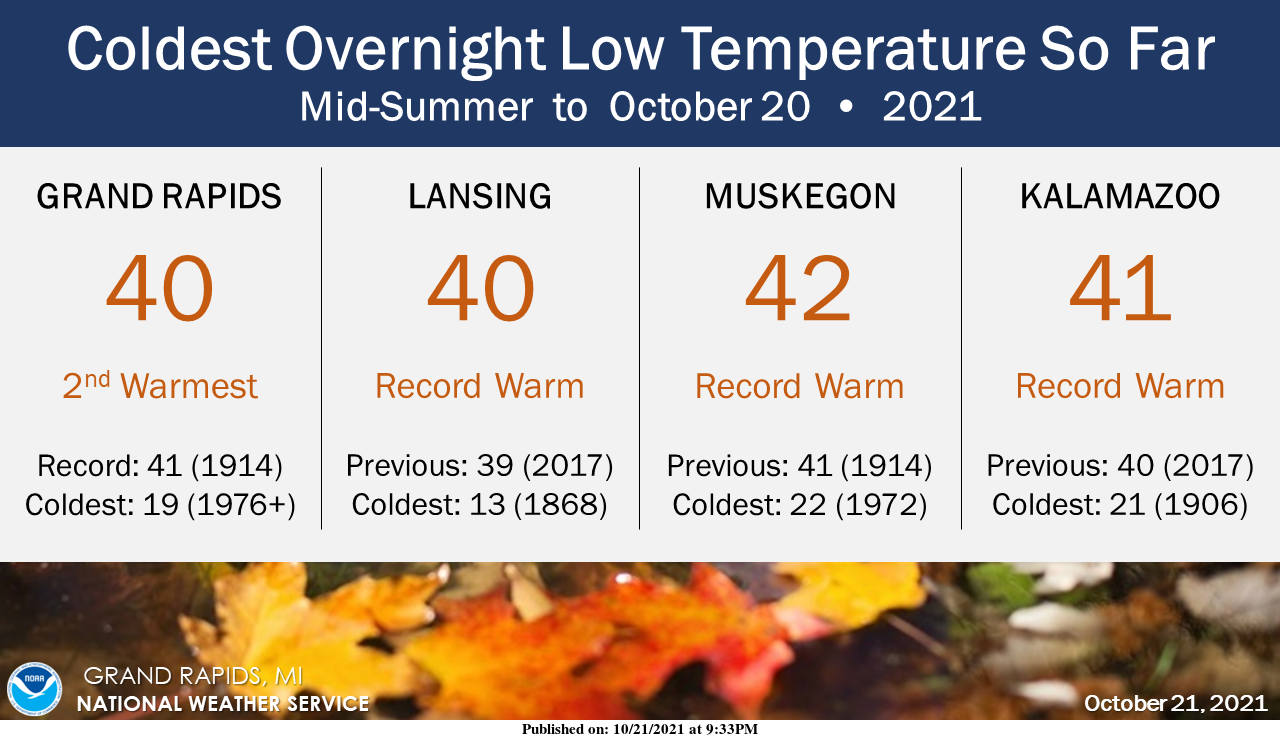
No temperatures in the 30s yet for Grand Rapids, Lansing, Muskegon, and Kalamazoo (but that should change this weekend). Overnight low temperatures up to this point in the season have been among the warmest if not the warmest on record, both in terms of average overnight temperature and the coldest temperature seen so far.
Our high temp yesterday was 59° and the low was 42°. We recorded .32 of an inch of rain which brings us to 3.68 inches for the month and 5.84 inches for the season.
This is an article of interest from CNN weather I found yesterday:
After nearly a year without rain, a series of potent Pacific storms are directed at Northern California this week, potentially bringing as much as a foot of rainfall and up to three feet of snow in the Sierra Nevada.

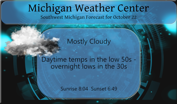
We will see more clouds than sun today and over the weekend – temps will remain cool with highs in the low 50s and lows in the 30s which may bring chances of frost tonight and Saturday night.
Forecast Discussion
Upper low will bring another cool day with some lake enhanced rain
showers in northerly flow. Some afternoon enhancement in coverage
of showers possible then decreasing this evening. Stratus deck
expected to persist overnight but any breaks will result in
frost formation as temperatures fall into the 30s. Same situation
expected for Saturday night as well.

Plains cyclogenesis on Sunday as shortwave trough moves out of the
larger scale troughing across the western CONUS. Surface low
tracks south of Lower Michigan Sunday night into Monday with an
area of strong mid-level frontogenesis moving across our area.
Steady rain expected with storm totals around an inch possible by
Monday afternoon.

Shortwave ridging follows for early next week then another chance
of rain by Wednesday as warm advection pattern with return flow
moisture arriving ahead of approaching cold front.
Just read that since September 25 we have only had 1 day come in below average. That is an incredible stat for the past month. I can’t think of any other stretch that has gone on this long.
This stretch is now at 26 days (it may end today) in the summer of 2012 between June 27th and August 4th there was just one day of below average temperature that was a stretch of 39 days. But I would think that this is one of the longest if not the 2nd longest. If I have time I will dig a little more into this
Slim
I found another one from December 10th 1931 to January every day was above average that is 40 days in a row.
Slim
Thanks Slim. Pretty rare territory we are in!
Several days back, a local TV met said we had gone 22(?) days straight with it staying above the average high AND average low. He said he had never recalled that happening in his 30+ years as a met.
Just finished mowing AGAIN.
Not sure how much longer it will last but there is still leaves on the trees in Houghton. I am sure this is one of the latest that has happened up there in many years if not the latest of all time”
https://www.mtu.edu/webcams/view/
There are more web cams if you click on the left hand side.
Slim
Yeah this is really getting late in the year for everything being green yet. My daughter went up North a few days ago for a “color” tour and she said about the only color they saw was green.
Currently the furnace has kicked on out in my area natural qas bills may jump 55% this year just like everything els brace yourself scarry times we are living fokes!!! Glad I started cutting wood last May…INDY
I heard 30% the other day on the news and I thought that was bad enough. My furnace isn’t on yet.
I believe I had a low of 36* this morning more 30’s for lows this weekend love it …INDY
The updated long range guess from the CPC was issued yesterday. Their guess for November is.
https://www.cpc.ncep.noaa.gov/products/predictions/30day/
For the next 90 days
https://www.cpc.ncep.noaa.gov/products/predictions/long_range/seasonal.php?lead=1
for meteorological winter.
https://www.cpc.ncep.noaa.gov/products/predictions/long_range/seasonal.php?lead=2
Their guess would play out for a wetter and milder winter. We shall see how that plays out.
Slim
Wetter and milder winter seems to be the consensus I’ve been reading.
They have the wetter part correct, however temps will be normal to slightly below normal! Tons of SNOW is in our future! Get prepared now!
The only thing I’m preparing to do is mow the yard again. Suns out, grass is long, keep on mowing.
There was 0.07″ of rain fall here yesterday while the day started sunny it became cloudy and was cool all day long with a few showers. The overnight low both here and at the airport was 37 that 37 at GRR was the 1st time it has dropped below 40 at Grand Rapids the fall season. It was also the 1st time it dropped below 40 since May 30th and it 2nd latest date for it to drop below 40 at Grand Rapids the latest date is October 25th 2017. At this time it is cloudy and 41 both here… Read more »
It was asked yesterday when was the first hard freeze last year. Well last year There was a low of 30 on October 16th and again on the 17th then there was a low of 25 on the 31st
Slim
Check out Mondays forecast bluster windy with rain temps in the low 40’s rest of the leafs will definitely be blowing off the trees the westher is turning fast Winter is approaching fast who would thought?? …….INDY
Feast or famine for precipitation out west. At least the reservoirs will get some much needed water.