Yesterday may be our final 70° day for the season as we drop down to closer to normal temps for mid-fall. We reached 73° with a low of 44°. A few sprinkles fell in the late afternoon amounting to about a trace of rain. We had around a quarter-inch of rainfall this morning so far. At 5 am it is 57° a temp which we don’t have much expectation of rising much above that mark.
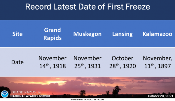
As a cold front approaches and we have yet to hit freezing. Here is the record latest Date of the first freeze for the area’s climate sites.
Still waiting for the first hard freeze in SW Michigan which would signal the end of the lawn mowing season. Last year at this time we had cooler than normal temps as related to the graph below from my weather station. The coolest overnight temps for SW Michigan for the rest of the week are predicted to be 34° on Saturday night.

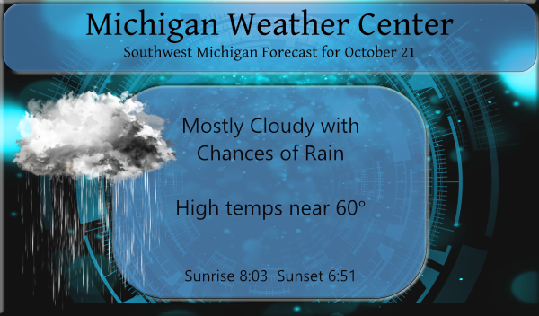
Mostly cloudy skies will prevail today with a steady temperature around 57. We will have southwest winds of 8 to 11 mph, with gusts as high as 23 mph. The chance of precipitation is 60%. New rainfall amounts of less than a tenth of an inch, except higher amounts possible in thunderstorms.
Forecast Discussion
--Storms exiting early; showers linger today--

Upper level jet streak /around 90 kts at 250 mb/ in the base of
the approaching potent shortwave trough over Iowa will continue to
drive a round of thunderstorms early this morning. Strong upper
level divergence related to the left exit region of this jet
departs the area to the east around 12Z, taking the current band
of storms with it. Some small hail and localized/narrow swaths of
1"+ rainfall amounts possible through sunrise.

As the upper low/vort max passes across srn Lwr MI today, expect
a continuation of showers - after brief dry slot occurs behind
the departing line of storms this morning. Highest pops today will
be in the mid level deformation zone north of I-96, especially
up along the U.S. 10 corridor where the showers should be
heaviest and most persistent today.

--Chilly, more seasonal, weekend--

H8 temps of around -2C pour south into the region tonight behind
the departing shortwave then the vortex over Hudson bay drops
south over the weekend. Highs Friday through Sunday only in the
lower to mid 50s, which is actually fairly close to normal for
this time of year.

The cold air and upper troughing will result in some lake effect
rain showers, but on Friday the weak low level flow should limit
those showers to mainly the coastal counties. A better chance of
showers spreading/developing farther inland exists on Saturday as
secondary trough swings through and broader nw flow develops.

On Sunday the low level flow becomes easterly due to the approach
of a Central Plains system. This will end the lake effect shower
threat, but expect increasing/thickening mid and high level cloud
cover related to incoming/upstream synoptic system. Rain should
reach the I-94 corridor by late in the day.

--Rain system Sunday night/Monday, another one midweek--

The next system coming in from the Pacific over the weekend passes
south of Michigan on Monday, but the deformation zone rain shield
impacts southern Michigan with steady rains Sunday night into
Monday. This looks like a cold rain too, as brisk easterly flow
holds temps in the lower 50s with gusts of 25-30 mph.

Yet another Pacific system emerges from the srn Plains for the
midweek period, which looks like it could phase in with
a digging/approaching nrn stream trough. This too may be a wet
system for the area around next Thursday/Friday.
What more rain and cool temperatures who knew ?? INDY
Incredible!
Sunny with a few clouds here. Got a bunch of rain from the t-storms early this morning. It’s not time to put away the lawnmower yet.
No its not time yet to but the lawnmower away yet. It has now cloudy here with some light rain falling and it is now down to 55.
Slim
You are lucky Rainy and drizzly here.
Just another of many cloudy, wet October days!
Wow, what a lightning show last night! It was already lightning to the West when I came home from work around 8, but by 10 and 11p.m. it was just incredible. Blinding, vivid streaks almost nonstop for a long time, one of the best displays of the year. Of course there’s the old saying, thunder in the Fall, no snow at all. There was a LOT of thunder!
Yep, it woke all of us up.
There is a old weather lore saying.
“Thunder in the Fall foretells a cold Winter.”
Here is some for from that site.
https://www.stormfax.com/wxfolk.htm
Slim
It sure was. The best all summer (Fall). The thunder was really loud. The lightning was actually blinding at times. We are on the top of a hill so it is amazing to see the storms move in.
Here is Grand Rapids area we had a nice thunderstorm overnight that dropped 0.45″ here at my house and the official amount at GRR looks to have been 0.46″ The overnight low here at my house was 56 and the official low so far at GRR looks to have been 58. At this time with partly cloudy skies it is 57 here at my house. So far this fall season the coldest official low at GRR has been just 40. The average date for the first low of 39 or lower is September 24th the latest date for a sub… Read more »
Some pretty good storms rolled through after 2am. A few window rattlers. Lol.
The first freeze that is in the chart above is for the first low of 32 or below. The latest first hard freeze (28 or lower) at Grand Rapids is November 29th 1948. For anyone who is thinking of a major pattern change all of the winters after the late first freeze listed above were mild to very warm with very little snow fall.
Slim
When was the first freeze and hard freeze last year?
There was a low of 30 on October 16th and again on the 17th then there was a low of 25 on the 31st
Slim