Happy Birthday to my lovely wife today. She is one of the (un)lucky ones who celebrated her birthday during Christmas week so the celebrations kind of blend into one another. We have a roofing crew coming in today for some roof replacement so we could assume this would be part of her birthday present (just kidding).
Yesterday we has some light snow with half an inch of accumulation. The high temp was 30° and the low 21°.
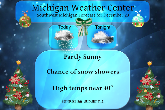
It will be mostly cloudy today with the chance of some light snow or a light wintry mix, especially northeast of Grand Rapids. Temperatures will climb back into the mid to upper 30s. Christmas Eve day looks to be another green day as will be Christmas day with chances of light rain. Temps will be in the 40s each day.
Below are some of the Christmas day extremes for Michigan:

- Light Snow Today -

Chances for light snow return today as a strong upper level jet
max and corresponding low amplitude mid level shortwave trough
move into the area. Isentropic lift late in the morning to
afternoon hours will support light snow, but limited moisture
should suppress widespread snowfall across much of southwest lower
MI with a better combination of forcing and moisture further
north. Main consensus on deterministic guidance suggests a swath
of snow around 1 inch north of I-96, mainly along the US-10
corridor.

The warm front will lift into southern MI by the evening with
temperatures pushing into the 30s. With increased moisture moving
into the area, the potential for fog or low stratus may need to be
monitored for overnight into Friday.

- Mild Holiday Weekend -

Upper flow will turn more zonal Friday and into the weekend with
several embedded shortwave pulses providing chances for
precipitation. Starting Friday, a broad upper wave will advance
into the Great Lakes region with southerly flow building Friday.
Temperates will be the warmest on this day with highs potentially
hitting 50 along the I-94 corridor. Light rain and/or drizzle will
be possible at this time with no travel impacts expected.

By late Friday night and into Saturday morning a cold front will
drop south with drier but not much cooler air for Christmas Day.
There doesn`t seem to be great run-to-run consensus on the
possibility for precipitation on Christmas Day, as recent
deterministic model trends suggest a frontal wave will track
across the southern state line bringing additional chances for
light rain or drizzle across the southern half of the state.

- Snow/Mix Possible Sunday Night into Monday -

Late Sunday into Monday will be our next time frame to watch for the
potential for some accumulating snow. All p-types will be on the
table with this system, with the onset expected to be mostly snow
thanks to low level cold air with easterly flow. By Monday we may
start to see snow mixing with sleet or freezing rain, then rain.
More time will be needed to iron out the details on timing,
strength, and p-type variation with this potential system.
It sure was a nice day outside today. We went out driving around looking at Christmas lights on houses and in yards this evening. So pretty! We saw some really high tech stuff.
Happy Birthday to Mrs V. Hope you had a wonderful day!!
Let snow let it snow INDY
Breaking news>>>>accumulating snow for Sunday night!
Just another of many cold winter days in West MI! Incredible!
Actually it was pretty nice out this afternoon. 38 degrees and partly sunny. Can’t ask for better than that in late December. Above average and yet another below average snowfall day. Incredible.
You are 100% wrong! Today was officially a below avg temp day in GR, as was yesterday and the day before! On top of that, I picked an inch of fresh snow today! Who knew?
GR hit 37 or 38 today, average high is 34. Sorry, 37>34.
Look at the entire day average and you see GR was 1 degree below normal for the day! As usual you are 100% wrong and I am 100% CORRECT! If you are going to post make sure you are not posting totally inaccurate information!
Looks like we were officially “pummeled” with 2 whole tenths of an inch of snow yesterday. Still not sure how one goes about measuring a tenth at a time. Microscope? Magnifying glass?
Guess what? Despite the constant warm weather hype on here, once again the current conditions = more COLD and SNOW! Keep it rocking!
Huh? It’s been an incredibly warm and snowless December.
Happy Birthday Mrs. V!
There is just a trace of snow on the ground here at this time. The overnight low here was 17. The official overnight low at GRR looks to have been 19. The temperatures still look to be above average for the next week or more and it sure looks like we well end the month of December warmer with less snow than average.
Slim
Happy Birthday to you wife. Hey a non leaking roof is a great birthday gift (just kidding)
Slim
Remember when WOOD predicted above average snowfall and cold in December?
Right now, GR is sitting on only 4″ of snow this month, almost a foot below average.
A Merry Christmas to all of you that visit this sight, and hopefully, we can get a little cold and snow for the new year!
Happy Birthday to your wife!!! We have lots of family and friends born in this week as well!!!