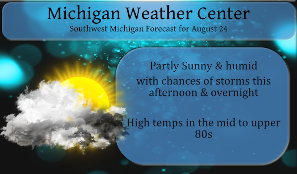
After a rather pleasant day yesterday, (we had a high of 83.5 in Otsego with lower dew points) we have another hot and humid day in store for today with highs in the upper 80s to around 90. Heat indices will push well into the 90s. Scattered showers and thunderstorms are possible both this afternoon and tonight. The chances for rain across the area are between 30-50 percent with the higher chances coming overnight. Southwest winds of 5 to 15 mph are anticipated.
We have chances of storms and popups right on through the weekend so I am assuming much of the state should see some much needed rainfall this week. If you like hot and humid weather you are in the right place!
Forecast Discussion
- Thunderstorms possible this afternoon and tonight

Rounds of showers and thunderstorms are possible this afternoon
into tonight. It appears the best chance in the next 24 hours will
be tonight. A warm front stretches from far Southern Lower
Michigan to the west-northwest across Northern Illinois into
Northern Iowa. This warm front will lift into Southwest Lower
Michigan today and may be the impetus for scattered thunderstorm
development as early as this afternoon. The warm front will move
north tonight with a cold front approaching from the west at the
same time. It appears we may see multiple rounds of storms tonight
in the warm sector. The SPC HREF indicates a scenario where
multiple rounds of storms may sweep northwest to southeast across
the area. Wind shear is largely weak in our area and therefore
agree with the SPC General Thunder risk. Cannot rule out some
marginally severe wind gusts as storms sweep in off the lake, but
that would be about it given the time of day the storms are moving
in (at night) and the weaker shear.

- Thunderstorm chances continue potentially into weekend

Thunderstorm chances cannot be completely ruled out almost each
day between Wednesday and Saturday. The cold front that will be
off to our west today will move into the area on Wednesday likely
producing another round of storms during the heat of the day. The
boundary then goes south into the Southern Great Lakes and lays
out as a stationary boundary for a time on Thursday. The front
will be meandering across the area Thursday night through Saturday
as a warm front much of the time. We stay in a hot and humid air
mass Wednesday through the weekend, so with a front in the area
scattered showers and storms will be a possibility almost every
forecast period.

A cold front looks to move through the area in the Sunday night
time frame which will likely bring another round of storms and a
push of slightly cooler air.

- Hot and humid rest of week and into weekend

Hot and humid conditions are expected from today through the
weekend. Either the dog days of summer or hazy, hot and humid
wording looks to work over the course of the next 5 to 6 days.
850mb temperatures of +19 to +22C should parlay into highs in the
upper 80s to lower 90s. We are thinking we will stay just shy of
Heat Advisory criteria today. We will be watching for heat
headlines over the coming days. It will be dictated by the rounds
of showers and storms and the cloud cover and precipitation that
comes with them.
“Showers and thunderstorms likely, mainly before 1am. Partly cloudy, with a temperature rising to around 76 by 1am. Light and variable wind. Chance of precipitation is 60%. New rainfall amounts of less than a tenth of an inch, except higher amounts possible in thunderstorms.”
It’s not very often that temps rise overnight.
Yeah no kidding. I’ve had enough of the heat for this year.
It sure was a hot one today!! 93 by me. No rain yet just lots of lightning.
Power outages all over the place! Wow!
I picked up 1.2 inches of much needed rain. Incredible!
Not a drop of rain here yet. There is almost a complete ring around us of storms and rain in all directions, but all we get is more heat. Made it to 93 here today with a 109 heat index. Yuck.
Severe thunderstorm warning here. A couple of claps of thunder and very little rain. Local TV met said it was issued for the wind and boy, he was right. The gust front was impressive. Another tree across the street snapped in half – near the one that was destroyed during the last warned storm.
At this time it looks like the storms will miss the Grand Rapids area. At this time there are storms to the NE of GR and to the SW of GR and it looks like a miss for here in GR. At this time it is now 82 and the dew point is now down to 69.
Slim
No rain yet out at my area just wind …Tipcal mis again …INDY
Apologies…ADA has no concept of the word “storm”, it’s definition, or usage in the English language. Carry on.
There was just a quick heavy shower here with one rumble of thunder. The dew point fell from 80 and is now down to 76 the air temperature is still at 90.
Slim
Hello downpour! Incredible rainfall right now!!!!!’nn
Our first 90 for the year – a lot of 88s and 89s though:
OFFICIALLY 90 DEGREES IN GR!!! HEAT INDEX OF 101!! Smoking hot!!!
There are some thunderstorms north of Muskegon and some very heavy storms to the west in Iowa with a lot of lightning at this time.
Slim
Latest Hazardous Weather Outlook. The heat just doesn’t want to go away
.DAY ONE…This Afternoon and Tonight
Thunderstorms will be possible through tonight. Severe storms are
not likely, but some could become locally severe. The strongest
storms will be capable of heavy rain, wind gusts to 60 mph, and
large hail up around the size of a quarter.
Hot and humid conditions this afternoon will push heat index values
into the 90s to around 100.
.DAYS TWO THROUGH SEVEN…Wednesday through Monday
Thunderstorms will be possible each day from Wednesday through
Sunday. Warm and humid conditions will persist into the weekend
with heat index values rising into the 90s at times.
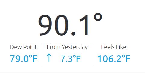
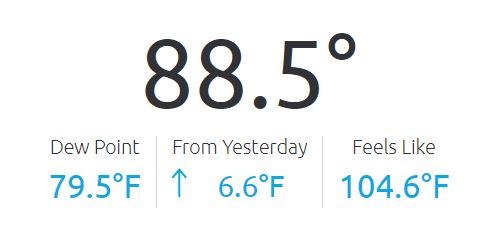
The latest temperature at GRR is 90 with a dew point of 76 good for a heat index of 101. But here at my house I have a temperature of 92 with a dew point of 80 yes 80 That is good for a heat index of 111.
Slim
WOW! There are 90s all over the area. Considering that the average high is only 80, that is quite remarkable.
Current weather here.
https://www.flickr.com/photos/184860862@N07/51400435023/in/dateposted-public/
Another 90-degree day here. According to WLNS, it is 93 with a heat index of 103.
The current readout at the Weather Center:
Holy smokes!
This is with partly sunny skies..
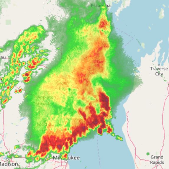
Forecast Discussion Update: A complicated convective pattern is setting up over the next few days, with the beginning of it coming as early as later this afternoon. We are watching two lines of storms over Wisconsin this morning. The first, moving toward the GRB area, was producing 55 knot wind gusts earlier. This line has weakened considerably as it outruns its support from the low level jet earlier, and encounters much less shear to the east to sustain it. This is evidenced by the outflow outrunning the better reflectivity. The second line further west has lost its strength also, with… Read more »
Storms at 3 pm – heading due west…
91 with a 74 dew point and the heat index is now 101 here. Looking at the PWS network around the area, most are at or above 90 degrees, as high as 93. Can’t argue this away, it is just plain HOT!
https://www.wunderground.com/wundermap?lat=42.83844800000034&lon=-85.93923199999972&zoom=13&tl.play=0&tl.spd=2&groupSevere=1&groupHurricane=1&groupFire=1&groupCamsPhotos=1&groupRealEstate=1&eyedropper=0&extremes=0&fault=0&favs=0&femaflood=0&fire=0&firewfas=0&fissures=0&fronts=0&hurrevac=0&hur=0&labels=0&lightning=0&livesurge=0&mm=0&ndfd=0&rad=1&rad.num=1&rad.spd=25&rad.opa=81&rad.type=00Q&rad.type2=&rad.smo=1&rad.noc=1&rad.stm=0&dir=1&dir.mode=driving&sst=0&sat=0&seismicrisk=0&svr=0&ski=0&snowfall=0&stateLines=0&stormreports=0&tor=0&tfk=0&tsunami=0&riv=0&wxsn=0&cams=0&pix=0
Phew! As of 2pm, GR was reporting 88 degrees with a heat index of 97 degrees. It’s cute how a few on here try to tell us this isn’t HOT LOL
I just got done mowing the lawn. Not too bad outside. Temp 86 degrees with a helpful breeze!
And Still No 90’s ……INDY
It is now officially 90 at GRR
Slim
Charlie Watts of the Rolling Stones has died at 80. His strong but unflashy drumming powered the band for over 50 years.
No way! Aren’t they coming to Detroit later this year? I saw them on the Steel Wheels tour in the Silverdome in 89(?). They were awesome.
Dew points approaching 80 again in some spots.
http://www.usairnet.com/weather/maps/current/michigan/dew-points/
Sturgis seems to always be tops. I guess that explains the Heat Advisory for the SW corner of the state.
I now have a dew point of 80 here at my house. That is the highest I have had but I only had this set up for 2 years.
Slim
Heat index is up to 92 already here, and it’s not even noon. This heat and humidity is getting ridiculous. Feels like Fall outside? Nope.
Currently the storms and rain in WI is moving away from us.
Already 78 with a 73 dewpoint at 10 am in Otsego – working outside this morning didn’t take much to work up a sweat. I generally get my outside work done before noon – this is why I am an early riser – I keep farmers’ hours – up early and to bed around 11 pm.

Watching storms this morning in northern Wisconsin heading towards northern lower Michigan – we are in the marginal outlook for severe weather later today and overnight.
The storms in Wisconsin still have a lot of lightning with them. At this time here at my house I have a temperature of 77 with a dew point of 73.
Slim
With no heat waves this summer, I think I have golfed more this summer than ever! Who would have thought?
Hot and humid just keeps going! Mark August down as another warm month.
It (August) is in the running for the warmest at Lansing and a top 5 at Muskegon. And a good chance of a top 15 or better at Grand Rapids.
Slim
We need rain!!! Whats up? Will we be seeing rain this afternoon/evening or not? It surely does not look like a sure thing! We need a good soaking – 1 to 2 inches of rain!
While I would not call it a true “heatwave” the Grand Rapids area now has had 6 days in a row of highs in the mid to upper 80’s and lows in the mid to upper 60’s It has been rather humid also for the past 6 days. The overnight low here at my house was a mild 68. The official low at GRR looks to be 67. At this time here at my house it is cloudy and 71 with a dew point of 68 while at the airport the 8AM reading was 70 with a dew point there… Read more »
Blake showed on tv this morning that there have been 17 days above average, one average, and only 5 below average this month. Highs near 90 for four of the next five days. August has been very warm – hot if you consider the humidity.
It is too early to say where this August will end up at but it is a very safe bet to place the August in the top 15 or so warmest at Grand Rapids and it is in the running for the warmest at Lansing and a top 5 at Muskegon. And it could be done with very few (if any) days of 90 or better.
Slim