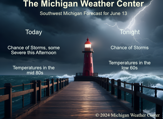
Thunderstorm chances will increase today as a cold front moves through. A few of the storms could be strong to severe with wind and hail the main threats. Upper ridging after that will set the stage for a several-day stretch of 90-degree weather, beginning Sunday and continuing through much of next week.
We still haven’t had any mosquitoes this year (Knock on Wood), I have to wonder if it doesn’t have to do with the lack of snow this winter. We live near the Kalamazoo River which tends to breed them along the shore. Strange indeed.

A scattered to broken line of storms will move through the area this afternoon as a cold front moves through the area. Some storms may become strong to severe. Damaging wind gusts and large hail are main hazards but an isolated tornado threat may develop in the strongest storms.
Weather History
1900: A tornado touched down near Marshall and passed north of Battle Creek, ending near Bellevue. Barns were destroyed at several farms along the path of the storm.
1994: A tornado struck Jackson County, producing a 16-mile damage path and injuring 2 people. More than a dozen homes were damaged or destroyed, along with other buildings.
2004: Severe weather struck across the region and a weak tornado touched down briefly in a field one-mile northeast of Stanton in Montcalm County
On June 13, 2004, an F1 tornado hit Huron County at 5:00 PM, causing $25,000 in damage. One property in this county lost 44 trees because of this tornado; many trees were very large and older than 100 years.
1972: Severe weather conditions over the Yucatan peninsula in Mexico begin to converge and form a tropical depression that would become Hurricane Agnes over the next two weeks. This hurricane affected most of the eastern United States with the Northeast being the hardest hit area with heavy rainfall.
1976: A deadly tornado moved across parts of the southwestern Chicago, Illinois suburbs killing three people and injuring 23 others. The tornado, with winds over 200 mph moved from Lemont to Downers Grove causing $13 million in damage when 87 homes were destroyed, and another 90 were damaged. The tornado passed over the Argonne National Laboratory, peeling part of a roof of the building housing a nuclear reactor. The tornadoes movement was somewhat erratic moving southeast to the north and finally turning northwest.
Forecast Discussion
- Strong storms remain possible for this afternoon and early evening

Our main focus and challenge initially will be on convective trends,
and what kind of severe potential will be present later today.

One factor with potential severe weather later today is the ongoing
convection this morning. We have a narrow broken line of showers and
a rumble of thunder embedded coming through the area right now.
Then, there is the leftover convection across Northern WI. The
convection over the area right now is associated with a weak short
wave and the southern edge of the low level jet nosing into the
area. The WI storms are better associated with the low level jet
dynamics with the core of the jet supporting the convection.

To start with, we have some outflow boundaries very evident on the
radar loops that are propagating to the south and east. The low
level jet will be weakening a bit as we approach sunrise as is
typical. Severe weather is not expected with any storms this
morning. What we do anticipate is the remnants of the storms and the
outflow boundaries will continue to progress toward the area. These
will likely have a decent say in where convection develops.

A majority of the models and their ensemble members have been fairly
consistent in showing that most of, if not all of the convection
will be south and east of the Grand Rapids area. In addition to
where the outflow boundaries end up, other factors will likely be
detrimental for widespread and severe convection for the vast
majority of the area. These are as mentioned last night, divergent
flow downwind of Lake Michigan, a cap in place, and the low level
jet moving away.

That seems like the more likely scenario. However, the HRRR and RAP
have been consistently showing the outflow boundary and effective
cold front igniting convection a bit further NW and more widespread.
This may have to do with instability being a bit higher with higher
sfc dew points. If the convection does ignite along the cold front
to our NW, it will have 2,000 J/kg of CAPE, and deep layer shear
values in the 30s. A unidirectional wind flow in the lowest few
thousand feet would support a wind threat, justifying the
conditional Slight Risk. We will continue to monitor the multiple
parameters mentioned above.

The front will sweep through the area no later than overnight. A
much drier and a bit cooler air mass will filter in over the area.
Much more stable conditions should keep the area dry on Friday, with
maybe some cumulus clouds mixing out.

- Becoming hot and humid

High pressure will be centered over the state Friday night and will
result in our coolest temperatures of the forecast period. We`re
looking at lows in the lower to mid 50s by early Saturday morning.
after that, the high moves east and south flow develops and warmer
and more moist air will advect north across Lower MI. A large
expansive upper high is progd to develop over the Ohio Valley/Great
Lakes next week and that usually means a heat wave this time of
year. H8 temps are progd to rise from 10c Saturday morning to 19c by
Tuesday. Sixty degree plus surface dewpoints won`t arrive until
Sunday which is when surface temperatures will close in on 90. Highs
Monday will be in the lower to mid 90s and heat indices will climb
to 95-100. Similar conditions are expected Tuesday through Thursday
too; we may be looking at an extended period of Heat Advisory
Criteria.

Given the juicy airmass in place, any minor short waves that ripple
across the region in the upper flow may be able to generate a shower
or storms, but nothing organized is expected. Thus, low
chance/isolated PoPs will carry the day.
Got a brief round of rain here at my house but not much. Severe storm went just south of Portland. A little rain is better than none though.
Striking out here. Lightning and thunder just to our south. Getting a few drops of rain but the outflow cooled the temps 10 degrees in the past 15 minutes. It’s now 78 here. 90 just to the southeast.
Looks sad…getting the feeling Ada may remain dry 🙁
Severe Thunderstorm Warning for…
Northeastern Barry County in southwestern Michigan…
Eaton County in south central Michigan…
* Until 445 PM EDT.
Well, here we go. It’s heading directly for my location.
Andddd…….it may miss me to the south. 🙁
Area Forecast Discussion
National Weather Service Grand Rapids MI
258 PM EDT Thu Jun 13 2024
.KEY MESSAGES…
– Low/Medium Confidence on Severe Storms this evening
– Near Record Heat and Bouts of Heavy Rain possible next week
https://forecast.weather.gov/product.php?site=GRR&issuedby=GRR&product=AFD&format=CI&version=1&glossary=1
SEVERE THUNDERSTORM WATCH 408 IS IN EFFECT UNTIL 800 PM CDT FOR THE FOLLOWING LOCATIONS MIC005-015-021-023-025-027-037-045-057-059-065-067-075-077-081- 117-139-149-159-140100- /O.NEW.KWNS.SV.A.0408.240613T1850Z-240614T0100Z/ MI . MICHIGAN COUNTIES INCLUDED ARE ALLEGAN BARRY BERRIEN BRANCH CALHOUN CASS CLINTON EATON GRATIOT HILLSDALE INGHAM IONIA JACKSON KALAMAZOO KENT MONTCALM OTTAWA ST. JOSEPH VAN BUREN
MD in effect. Watch possible:
https://www.spc.noaa.gov/products/md/md1247.html
No mosquitos here (yet) either. My son and I golfed Tuesday at a course that runs along the Red Cedar. It’s very low and almost swampy. The mosquitos are usually an issue there so we brought the repellant, but there were none.
Looks like mosquitos are out in Michigan you might be lucky to not have see many yet. My guess is they are out there. Here is a report that they are out there.
https://www.cbsnews.com/detroit/news/michigan-mosquito-jamestown-canyon-virus/
Slim
As mentioned in the post lack of snowfall contributes to less ponding where they emerge.
https://www.mlive.com/news/2024/03/why-michigans-early-mosquito-emergence-has-a-silver-lining-sort-of.html
Here in MBY I had a overnight low of 68. Yesterday and overnight I had 0.09” of rainfall at the current time it is 69 here with cloudy skies. There is some rain and storms off to the NW and W of here at this time.
Slim
The official H/L yesterday was 84/56 there was 0.09” of rainfall the sun was out 53% of the time. For today the average H/L is 79/58 the record high of 95 was set in 1894 the record low of 39 was set in 1985. The coldest high of 59 was set in 1955 and the warmest low of 72 was set in 1892. The most rain fall of 2.23” fell in 2005. Last year the H/L was 70/49 and there was 0.07” of rainfall.
Slim