Today is our anniversary we have been married for 51 years. I always like to have a record of the weather on days that are easy to remember like anniversaries, birthdays ect. So while this will be useless information to many of you it in a way means a lot to me LOL.
When we got married my wife to be lived in Linwood that is about 10 miles north of Bay City. Her family live very near Saginaw Bay and from their house you could walk to the bay. The beach in that area is kind of marshy so swimming is very limited. On the day of our wedding, it was a cloudy and rather cool day the official high at Tri City airport for the day was 76 but not sure if it was that warm in Linwood. There was no rain reported at the airport but there was a very heavy shower just as we were leaving for the church and yes we got somewhat wet.
We went to Munising for our honeymoon and as is typical of the UP it was mostly cloudy, cool and wet. We did have a couple of warm days but then back to cool and wet again. Our time there was 3 days in the 60’s 2 days in the 50’s one day at 82 and one at 79. For lows we had 2 nights in the 30’s 2 nights in the 40’s and 3 in the 50’s so of course no air was needed. It rained on 6 days but we still had a great time. The small motel we stayed at is no longer there. Yes, we had a great time.
We are now 2/3 way thru June 2024 the mean at Grand Rapids so far this month is 70.4 that is a departure from average of +2.8 the highest so far this month and year is 94. So far there have been 3 days of 90 or better and that is the average for June. There have been 3 more days of 87 or better and the average is 6 so we are now at average for days of 87 or better. The low for the month so far has been 45. There has been official 1.13” of rain fall here in MBY there has been much less rainfall. I have only had 0.62″ here.
The official H/L yesterday at Grand Rapids was 89/68 there was no rainfall and the sun was out 60% of the time. For today the record high of 97 was set in 1894 and 1923 the coldest high of 56 was set in 1902 the record low of 39 was set in 1992 the warmest low of 73 was set in 1908. The most rainfall of 1.92” fell in 1928.
AREA FORECAST DISCUSSION
NATIONAL WEATHER SERVICE GRAND RAPIDS MI
333 AM EDT SAT JUN 22 2024
KEY MESSAGES
-POTENTIAL SEVERE WEATHER AND FLOODING TODAY/THIS EVENING
-DRY MONDAY, STRONG STORMS POSSIBLE TUESDAY/TUESDAY NIGHT
-DRY WEDNESDAY/THURSDAY, STORMINESS RETURNS NEXT WEEKEND
DISCUSSION
ISSUED AT 332 AM EDT SAT JUN 22 2024
-POTENTIAL SEVERE WEATHER AND FLOODING TODAY/THIS EVENING
A WARM FRONT HAS LIFTED TO THE NORTHERN CWA EARLY THIS MORNING
WHERE IT’S EXPECTED TO BECOME QUASI STATIONARY TODAY. LOW PRESSURE
IN NEBRASKA WILL MOVE ENE TOWARD WISCONSIN BY THIS AFTERNOON. A
STRONG SOUTHWEST FLOW AHEAD OF THE LOW IS HELPING TO BRING IN
MOISTURE-RICH AIR AND PRECIPITABLE WATER VALUES IN EXCESS OF 2
INCHES IS EXPECTED TODAY.
THERE WILL BE SOME DESTABILIZATION AHEAD OF THE LOW ACROSS THE
NORTHERN AND CENTRAL CWA TODAY. THUNDERSTORMS WILL LIKELY SPREAD
EAST FROM WISCONSIN. CAPE VALUES ARE NOT PARTICULARLY IMPRESSIVE.
HOWEVER, SHEAR VALUES INCREASE TO 45 KNOTS THIS AFTERNOON. AN
IMPRESSIVE LLJ IS PROGD TO MOVE TOWARD THE NORTHWEST CWA THIS
AFTERNOON. A WEAK SHORT WAVE ALOFT WILL AID IN CONVECTIVE
GENERATION. IT’S POSSIBLE THAT AS THE SHEAR INCREASES WE COULD SEE
SOME LOW TOPPED SUPERCELLS DEVELOP. IMPRESSIVE HELICITY VALUES
AROUND 400 M2/S2 MOVE OVER THE NORTHERN ROWS THIS AFTERNOON NEAR
THE FRONTAL BOUNDARY. IT’S NOT OUT OF THE QUESTION A TORNADO OR
TWO COULD SPIN UP ALONG THE BOUNDARY.
AS THE LOW CROSSES NORTHERN LOWER AROUND 00Z, THE TRAILING COLD
FRONT WILL BEGIN TO MOVE SOUTH. SHOWERS/STORMS WILL FORM ALONG THE
COLD FRONT AND MOVE ACROSS THE REST OF THE CWA DURING THE EVENING
AND OVERNIGHT. AREAS SOUTH OF I-96 WILL LIKELY SEE A BIT MORE
DESTABILIZATION TODAY DUE TO A BIT MORE SUNSHINE. AND SO ANY
STORMS THAT FORM ALONG THE COLD FRONT WILL BE ABLE TO TAP INTO
THAT INSTABILITY. STRONG WIND GUSTS AND TORRENTIAL RAINFALL WILL
BE THE MAIN THREATS. PRECIPITATION WILL BE ENDING BY SUNDAY
MORNING.
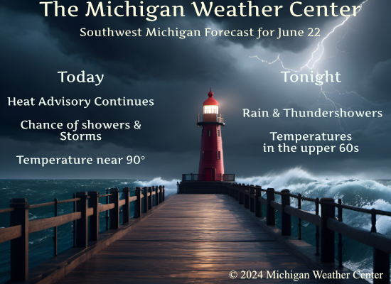
TODAY WILL BE THE LAST DAY OF THE HEAT ADVISORY. HEAT INDICES WILL
TOP OUT IN THE MID 90S AGAIN TODAY. A COLD FRONT WILL MOVE ACROSS
THE STATE TONIGHT LEADING TO HIGHS IN THE 75 TO 80 DEGREE RANGE
SUNDAY.
-DRY MONDAY; STRONG STORMS POSSIBLE TUESDAY/TUESDAY NIGHT
MONDAY WILL FEATURE SUNSHINE AND COMFORTABLE TEMPS/HUMIDITY WITH
SURFACE RIDGING IN CONTROL BEFORE A WARM FRONT RETURNS ON TUESDAY
AND SENDS BACK THE HEAT AND HUMIDITY FOR A DAY. GFS HAS SB CAPES
EXCEEDING 3000 J/KG TUESDAY AFTERNOON ONCE THE WARM SECTOR ARRIVES,
SETTING THE STAGE FOR THE POSSIBILITY OF SOME STRONGER STORMS BY
EVENING AS A COLD FRONT AND H5 SHORTWAVE TROUGH APPROACH FROM THE
NORTHWEST.
-DRY WEDNESDAY/THURSDAY; STORMINESS RETURNS NEXT WEEKEND
THE COLD FRONT EXITS EARLY WEDNESDAY AND WE DRY OUT BY AFTERNOON AS
COOLER/DRIER AIR ARRIVES FROM THE NORTH. HIGH PRESSURE SETTLES IN
FOR THURSDAY WITH DRY WEATHER STILL PREVAILING, BUT THEN MODELS
DIVERGE WHICH LEADS TO LOW CONFIDENCE TIMING THE RETURN OF OUR NEXT
CHANCE OF SHOWERS AND STORMS. THE MORE PROGRESSIVE GFS HAS RAIN
CHANCES RETURNING ALREADY ON FRIDAY WHEREAS ECMWF HOLDS OFF UNTIL
SATURDAY.
Detailed Forecast for Grand Rapids
Today
A 40 percent chance of showers and thunderstorms, mainly after 8am. Mostly cloudy, with a high near 89. Southwest wind 5 to 13 mph, with gusts as high as 22 mph.
Tonight
Showers and possibly a thunderstorm. Low around 67. Southwest wind 11 to 15 mph, with gusts as high as 28 mph. Chance of precipitation is 90%. New rainfall amounts between a quarter and half of an inch possible.
Sunday
Showers likely and possibly a thunderstorm before 8am. Partly sunny, with a high near 76. West northwest wind 8 to 10 mph, with gusts as high as 23 mph. Chance of precipitation is 60%. New precipitation amounts of less than a tenth of an inch, except higher amounts possible in thunderstorms.
Sunday Night
Mostly clear, with a low around 61. West northwest wind 3 to 8 mph. Winds could gust as high as 18 mph.
Monday
Sunny, with a high near 83. Calm wind becoming west around 6 mph in the afternoon.
Monday Night
Mostly clear, with a low around 64.
Tuesday
A 40 percent chance of showers after 8am. Partly sunny, with a high near 89.
Tuesday Night
A chance of showers and thunderstorms. Mostly cloudy, with a low around 68.
Wednesday
Mostly sunny, with a high near 84.
Wednesday Night
Mostly clear, with a low around 56.
Thursday
Sunny, with a high near 80.
Thursday Night
Mostly clear, with a low around 58.
Friday
Mostly sunny, with a high near 84.
It is really windy and the rain is pouring down. Our lights keep blinking. They said 4000 are without power. Most traffic lights are out.
HAPPY 51st ANNIVERSARY TO SLIM AND HIS WIFE.
ALSO HAPPY 27th ANNIVERSARY TO *SS* AND HIS WIFE.
MY HUSBAND AND I JUST CELEBRATED OUR 54th ANNIVERSARY.
Wow!!Happy Anniversary Sandy & Mr. Sandy!!! Lol…
Thanks for the anniversary wishes as well!!!
Thank-you. I remember the day we got married it thunder stormed in the morning and then it got very hot and humid.
This hazardous weather outlook is for portions of southwest Lower
Michigan.
.DAY ONE…Tonight
Strong to severe thunderstorms are possible overnight. Damaging wind
gusts will be the main threat. Torrential rainfall is also possible,
especially north of I-96, and this may lead to localized flooding.
.DAYS TWO THROUGH SEVEN…Sunday through Friday
Strong to severe thunderstorms are possible Tuesday.
The June drought appears unstoppable. Sprinklers on 🙁
No drought here. i have seen 2.75 inches this week and more is on the way! Incredible rain!
…A TORNADO WARNING REMAINS IN EFFECT UNTIL 430 PM EDT FOR NORTHERN GLADWIN COUNTY… At 357 PM EDT, a severe thunderstorm capable of producing a tornado was located over Skeels, or 7 miles north of Gladwin, moving east at 30 mph. HAZARD…Tornado. SOURCE…Radar indicated rotation. IMPACT…Flying debris will be dangerous to those caught without shelter. Mobile homes will be damaged or destroyed. Damage to roofs, windows, and vehicles will occur. Tree damage is likely. This dangerous storm will be near… Hockaday and Bowmanville around 415 PM EDT.
We have been moved out of the slight risk area for today.
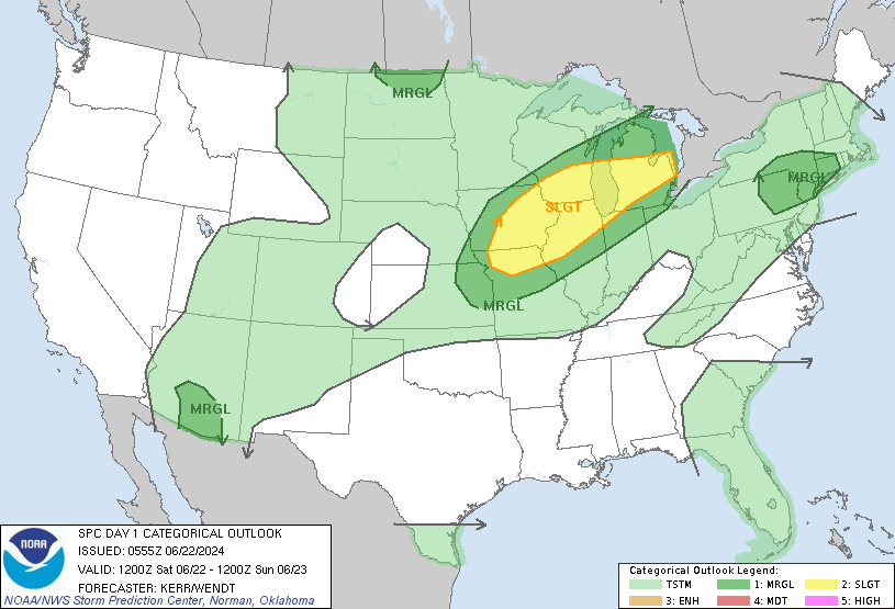
https://www.spc.noaa.gov/products/outlook/day1otlk.html
Slim
UPDATE… Issued at 1137 AM EDT Sat Jun 22 2024 Based on the latest wave model forecasts, we expanded the small craft advisory and beach hazards statement one county/zone further north. One area of heavy rain was tracking through the Pentwater to Ludington region. It appears that fairly widespread amounts of around an inch may accompany this initial batch. Additional heavy rain is likely this afternoon and evening with the storms in southern WI tracking east northeast. Off of SPC`s meso analysis page, PWAT values were around 2 inches in this region with really impressive 925-850 mb moisture transport going… Read more »
Horrendous weather with high dew points!
Did not get much rain here this morning just 0.4″ in the rain gauge. Things are getting really dry in my area. The current temperature/dew point is 85/72 with cloudy skies. I work outside at the Whitecaps and it was rather hot in the sun last night. I was just outside and with the clouds it really is not all that bad out. I will water the plants as I am not sure just how much rain we will get here in MBY.
Slim
Flood watch was a bust. We got 0.1” the past 24 hours. So far, it’s a joke. The yard is brown and corn in my immediate area is curled with brown tips.
86 with a 73 dp – yuck
The yard/gardens sure could use an all night rain.
Yes!!!
Happy Anniversary Slim!!! 51 years is quite an accomplishment!!! We will be celebrating ours next week 27 yrs!!! A lot of June-versaries here.
Have a great day and stay cool!!!
Happy early anniversary, SS! 27 years is also amazing.
SPC Day One
Happy anniversary!
Happy anniversary, Mr & Mrs Slim! 51 years is quite an accomplishment. My beautiful bride and I celebrated 22 years earlier this month.
So today will be the official end to this heat wave? I hope so. It would not break my heart if we don’t have another one this year.
Now you are talking!