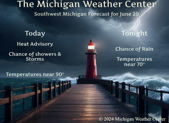
Yup, the summer solstice begins at 4:51 pm today as our tropical air remains in place. The heat advisory also remains though has been lifted for several counties to the north.
...HEAT ADVISORY NOW IN EFFECT UNTIL 8 PM EDT SATURDAY...

* WHAT...Heat index values up to 96.

* WHERE...Calhoun, Eaton, Ingham, Jackson, Allegan, Barry,
  Kalamazoo, Kent, Ottawa, and Van Buren Counties.

* WHEN...Until 8 PM EDT Saturday.
Yesterday’s high and low temperatures were 90° and 73° respectively. We had .15 inches of rain overnight bringing our total to 2.16 inches for the month.
Weather History
1953: An early summer heat wave peaked with temperatures around 100 degrees. It was the hottest June day on record at Grand Rapids with a high of 102 and a sultry low of 79 degrees
On June 20, 2021, severe storms, including the first tornado of 2021, occurred during the evening and overnight hours. The bulk of the severe weather occurred over the Metro Detroit region as well as Monroe and Lenawee Counties, and much of the region saw soaking rainfall that provided some relief to the ongoing moderate to severe drought. A brief EF1 tornado occurred near Riga in Lenawee County just before 9:30 pm, damaging 5 homes, 4 outbuildings, 3 barns, and numerous trees. This was the first tornado in Lenawee County since June 2010.
On June 20, 1992, the high temperature for Flint reached a chilly 51 degrees after a cold front had passed the day before. This temperature reading turned out to be the record-low maximum for this date. This record low maximum was one of several that occurred over Southeast Lower Michigan during the “Cold Summer of 1992”.
1970: Nesbyen, Norway reached 96 degrees on this day, becoming the warmest temperature recorded in Norway.
2001: Large hail driven by strong thunderstorm winds raked Denver International and front-range airports. Wind gusting to 54 mph along with hail as large as 2 inches in diameter punched at least 14 thousand holes and cracks in the flat roofs of several buildings at Denver International Airport. Also, 93 planes and hundreds of cars were damaged. About 100 flights had to be canceled stranding 1500 travelers. The Airport was completely shut down for about 20 minutes. The storm also damaged ground avoidance radar used to track planes on the ground to prevent collisions. Damage was estimated at 10 million dollars not counting the cost to the 93 airliners. The storm moved south and struck Watkins Colorado with hail as large as 2 1/2 inches in diameter and winds gusting to 60 mph.
Forecast Discussion
- Continued hot/humid with scattered storms

Radar shows scattered storms moving east of US-131 and north of
I-96. These formed southwest of GRR earlier in an area where low
level lapse rates were maxed around 5.5 c/kg and LI`s were around
-5c. These storms will move out of the cwa by 12z.

Surface obs indicate a weak cold front is located near M-46 and
moving south. Convergence near this boundary coupled with various
weak outflow boundaries will continue to produce convection today.
Additionally, northeast winds behind the frontal boundary will
converge with lake breeze boundaries that develop behind the wave
of low pressure that the GFS/ECMWF have for a couple of days
showed that moves ENE along the frontal boundary and that will
likely result in more showers/storms today. PWATs are progd close
to 2 inches again this afternoon, so a heavy rain threat exists.
Indeed, local probability matched mean from the 00z HREF shows the
potential for 1-2 inch rainfalls in the heavier cells that
develop. The rain loading could also result in some stronger wind
gusts.

South of the frontal boundary, heat and humidity will remain with
heat indices 95-97 degrees.

Temperatures will fall to around 60 tonight over the northern cwa
that will be influenced by the northeast winds from Lake Huron.
Elsewhere lows will fall into the upper 60s. Generally dry
conditions are expected tonight.

Friday will see highs 85 to 90 with heat indices 94-96 degrees.
The weak frontal boundary from today will move north Friday
generating more scattered convection. Given PWATs aoa 2 inches,
a heavy rain threat will exist.

- Very warm and windy Saturday; Heat Advisory extended

Breezy warm sector will overspread Southwest Michigan on Saturday as
a warm front lifts into nrn Lwr MI with a cold front situated to our
west from near MSP to DSM. Southwest wind gusts of 30-35 mph
possible in the afternoon once deeper mixing gets going within
tightening, cyclonic sfc pressure gradient. Much of the day should
be dry, at least near and south of I-96, with highs in the lower 90s
away from Lk MI. The heat advisory over srn sections has been
extended into Saturday to account for this final surge of hot air.
Highest pops will be up near U.S. 10, closer to the sfc warm front.

- Showers and thunderstorms Saturday night

A shortwave preceding the primary H5 trough approaching from the
northwest comes through on Saturday night along with the sfc cold
front. While deep layer shear values around 35 kts would support the
possibility of strong to severe storms, it`s questionable how much
instability will be available given the late-night frontal passage.
Either way will have high pops (60-90 percent) during this time.

- Dry and somewhat more comfortable Sunday through Tuesday

We eventually dry out on Sunday behind the cold front with temps and
dew points falling to more comfortable levels. A surface high moves
in for Monday and that may keep things dry into Tuesday as well.
However pops ramp up again by midweek as the next cold front and H5
trough drop in from the northwest. An even cooler air mass looks to
follow that front by around Thursday of next week with dew pts
dropping into the 40s.l move north Friday and spur scattered
convection. Once again heavy rain will be possible given PWATs aoa
2 inches.
What a crazy day of weather. I wasn’t expecting a tornado warning at my house but weather will do what it wants I guess. I picked up quite a bit of rain so it will certainly help the dry conditions
Looks like a little rotation near Dimondale. No tornado warning but severe warning says tornado possible.
The hail core passed just to our south. Ingham county sheriff reported quarter-sized hail about a mile down the road. Not much lightning with these storms. Just heavy rain and some hail. It’s been raining steadily here for about the past 20 or so minutes.
Pretty crazy day weather wise. More than I was expecting.
BULLETIN – EAS ACTIVATION REQUESTED Tornado Warning National Weather Service Grand Rapids MI 357 PM EDT Thu Jun 20 2024 The National Weather Service in Grand Rapids has issued a * Tornado Warning for… East central Kent County in southwestern Michigan… Northwestern Ionia County in south central Michigan… * Until 445 PM EDT. * At 356 PM EDT, a severe thunderstorm capable of producing a tornado was located 7 miles west of Belding, or 8 miles southwest of Greenville, moving southeast at 15 mph. HAZARD…Tornado. SOURCE…Radar indicated rotation. IMPACT…Flying debris will be dangerous to those caught without shelter. Mobile homes… Read more »
Saw the activity developing out west so I just mowed. It’s a sweat fest outside. Hoping that some precip will cool it down a bit. C’mon, rain!
The National Weather Service in Grand Rapids has issued a
* Severe Thunderstorm Warning for…
Northeastern Kent County in southwestern Michigan…
Northwestern Ionia County in south central Michigan…
* Until 430 PM EDT.
* At 344 PM EDT, a severe thunderstorm was located 6 miles east of
Rockford, or 9 miles southwest of Greenville, moving southeast at
15 mph.
HAZARD…60 mph wind gusts and quarter size hail.
SOURCE…Trained weather spotters.
Was under the punishing rain in Cascade, watched the storm move East to Lowell as it went “Severe”. Good atmosphere for a little growth.
Tornado warning at my house. Cool cloud structure to the storm.
* Tornado Warning for…
Southeastern Ionia County in south central Michigan…
Northeastern Barry County in southwestern Michigan…
Southwestern Clinton County in south central Michigan…
Northwestern Eaton County in south central Michigan…
* Until 345 PM EDT.
* At 305 PM EDT, a severe thunderstorm capable of producing a tornado
was located near Lake Odessa, or 11 miles southwest of Portland,
moving southeast at 20 mph.
HAZARD…Tornado and golf ball size hail.
SOURCE…Radar indicated rotation.
The National Weather Service in Grand Rapids has issued a
* Severe Thunderstorm Warning for…
Southern Ionia County in south central Michigan…
Northeastern Barry County in southwestern Michigan…
Southwestern Clinton County in south central Michigan…
Northwestern Eaton County in south central Michigan…
* Until 400 PM EDT.
* At 254 PM EDT, a severe thunderstorm was located near Lake Odessa,
or 9 miles south of Ionia, moving east at 20 mph.
HAZARD…Golf ball size hail and 70 mph wind gusts.
SOURCE…Radar indicated.
Severe Thunderstorm Warning for… Southeastern Kent County in southwestern Michigan… Western Ionia County in south central Michigan… * Until 300 PM EDT. * At 206 PM EDT, a severe thunderstorm was located near Gerald R. Ford International Airport, or 12 miles east of Grand Rapids, moving east at 10 mph. HAZARD…60 mph wind gusts and penny size hail. SOURCE…Radar indicated. IMPACT…Expect damage to roofs, siding, and trees. * Locations impacted include… Ionia… Lowell… Lake Odessa… Saranac… Gerald R. Ford Inter…Ada… Clarksville… Alto… Cascade…
Quite a surprise. Getting out this morning finding everything soaked. Appreciate the rain, but would have appreciated covering furniture cushions more. Oh well.
Zero rain here and we don’t know your location, so your comment is not relevant!
A pop up storm hit us at 4a this morning. It absolutely poured for ten minutes before moving on to the NE. ‘Twas a nice surprise to wake us up.
Seen rain north and east of me this morning. The pop ups seem to be avoiding my area.
I am traveling back to the state on Friday from a quick vacation. But my neighbors have been saying that the area got dry very rapidly. Looks like we are now abnormally dry according to the drought monitor. https://droughtmonitor.unl.edu/CurrentMap/StateDroughtMonitor.aspx?MI
Three 90+ degree days so far this year and it’s only mid June! Contrary to some’s so called predictions on here, June is yet another warm month.
Breaking News>>>>>>global warming is real and it is devastating! How could anyone not face the facts and how could anyone utter the words global warming is good? Incredible ignorance!
Not sure this is the place to argue that topic. There are plenty other blogs out there for that.
Thanks Barry and I will remember this advice the next you post about the restaurant business!
I just watched a clip from the 1980’s that stated the global scientific community believed that more than a third of Florida would be underwater by 2000. I also remember Bernie Sanders telling us 8 years ago that entire cities would be underwater by 2025 LOL Warming has been wonderful for Michigan!
Al Gore also said the arctic sea ice would be almost entirely gone by 2020! Silly that Rocky is so terrified of these doomsday predictions when nearly all of them have been a bunch of bunk! All these climate schemes are just huge money grabs of tax paying Americans!
Wow more made up conspiracy theories! Pathetic!
If these comments were not so pathetic they would be funny! WOW!
Welcome to astronomical summer the summer solstice will be today at 4:50 PM. After that we start our trip towards fall and then winter. The overnight low here in MBY was 75 and there has been a trace of rainfall.
Slim
The official H/L yesterday at Grand Rapids was 93/76. That 76 was the 2nd warmest minimum for any June 19th 2nd only to the 77 in 2012. There was just a trace of rain fall and for the month we are now at 0.83” that is a departure of -1.69 for the year we are now at 15.76 that is a departure of -1.78” For today the average H/L is 81/60 the record high of 102 was set in 1953 that year also had the warmest low of 79. The record low of 41 was set in 1970 the coldest… Read more »