I had all the leaves removed from my property until the south winds blew all the neighbor’s leaves into my front yard yesterday. My fish pond is thick with oak leaves. So we will be out raking and mulching today, hopefully for the last time this year. It is about time to get the mower deck off the tractor and install the plow and snow chains as we are in the time of year when snow could fall at any time.
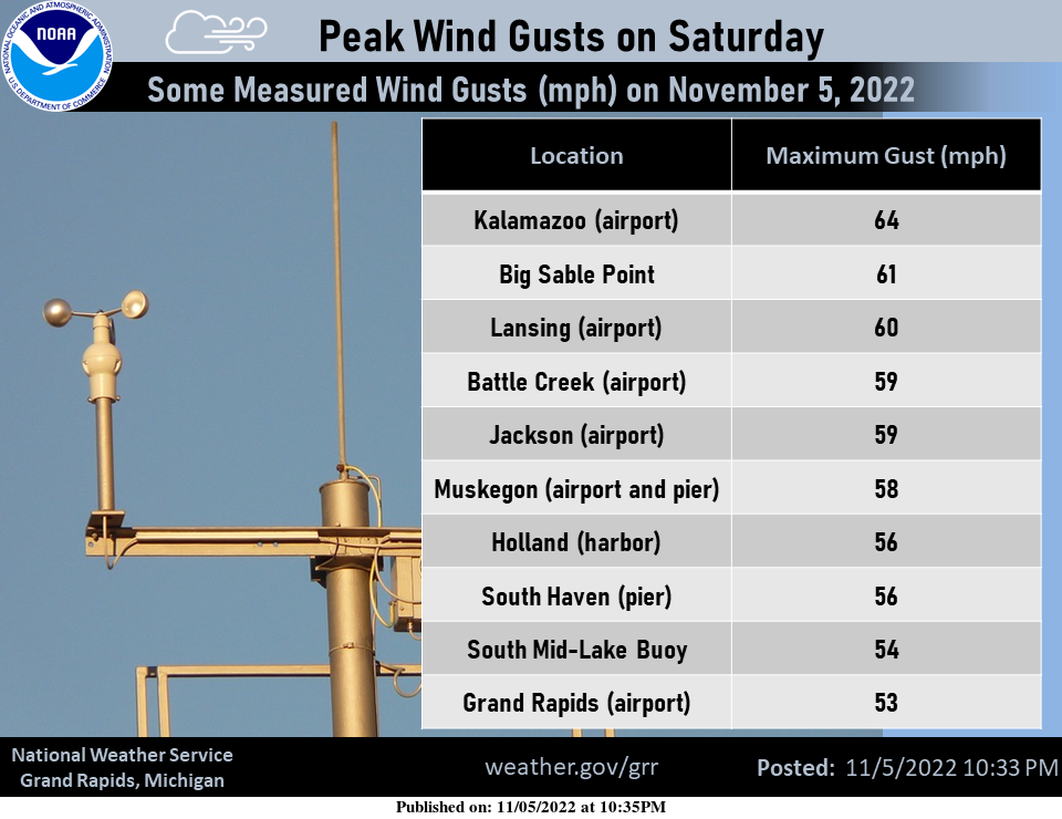
True to the season of “November gales” in the Great Lakes, a strong low-pressure system passed through the region on Saturday. Gusty winds caused scattered power outages throughout Lower Michigan and parts of the U.P. The NOAA buoy in northern Lake Michigan measured wave heights to 17 ft. Here are a few of the gusts clocked at some of the official observing sites in our forecast area.
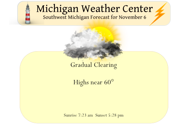
Yesterday we had a high of 68° and the low was 49°. The rainfall total was only a tenth of an inch. Enjoy this week and finish up any outdoor activities that need to be done – snow showers come into the forecast by Friday night and Saturday! Long-range outlooks are guessing below-normal temperatures after Friday through the rest of the month.
Forecast Discussion
- Breezy Today; Tranquil Weather into Mid Week

One more day with gusty winds to get through, but not as bad as
Saturday. After a reprieve in the wind gusts into early morning,
there will be a resurgence in 925mb winds of 30-40 kts during the
late morning into afternoon, which Bufkit mixing heights reveal we
should be able to tap. The highest gusts will likely be along the
lakeshore north of MKG where some sfc gusts could reach the 35-40 kt
(over 40 mph) at times. Most inland locations should have gusts in
the 30-40 mph range, so that is lower than Saturday for sure but
still breezy. Winds will greatly tail off toward sunset and beyond.
Monday looks much less breezy with 10-20 mph expected.

There is good model agreement on dry conditions, seasonable
temperatures, and a fair amount of sun for Monday and Tuesday as
upper ridging dominates the Great Lakes during that time. Low level
warm air advection increases markedly for Wednesday and Thursday
with 850mb temperatures rising into the 12C-15C range. With deep
southwest synoptic scale flow in place by Thursday, we should be
able to mix down dry adiabatically from about 900mb and boost highs
back to around 70 away from the lake. Aside from something
climatologically extreme happening later this month, that should be
the last day we`ll reach 70 anywhere for quite some time.

- Turning Breezy Again Late Week, With Some Rain Showers

An upper low approaching the Pacific NW at this time is slated to
move into the Upper Midwest by late in the week. Given its
trajectory over the Rockies midweek, lee cyclogenesis is forecast by
medium range guidance and a deepening low is expected to move toward
Minnesota by Thursday before occluding. This type of storm track
would not give our region significant rainfall, but it would get us
into the warm sector and provide a period of gusty winds especially
Thursday into Friday. A cold front will probably sweep through the
state sometime Friday afternoon or evening. Even five days out,
forecast confidence is pretty good on FROPA timing.

- Colder Air and Lake Effect Snow Showers Arrive This Weekend

There is really little doubt that cold air advection behind this
front will be sufficient enough for lake effect snow shower
generation Saturday into Sunday. GFS ensemble spread on 850mb
temperatures is not large when looking at the 25th-75th percentiles
this coming weekend. At least at this long range, low level moisture
looks pretty solid off the GFS/ECMWF/GEM, so the main question may
be wind direction which is certainly in flux this far out. A general
transition from W/WNW/NW flow is the early indication over the
course of the weekend. Some accumulating snow is favored by most
ensemble members for various locations mainly near and west of US
131, but this is too far out to talk specifics and precise
locations. That said, this coming weekend will be the first time
this season that any sort of travel impacts could potentially
occur due to winter weather. The ensemble guidance favors
temperatures to be below normal starting this upcoming weekend and
likely several days beyond that. This would equate to highs
mainly in the 30s for many locations.
Great news…..All signs point towards a cold snowy winter! Get ready to rock!
Very windy here late afternoon/early evening. My yard was free of leaves until yesterday, as well. On the bright side, all the leaves that arrived yesterday swirled and piled up in two corners of the house. It will not take long to tend to them. My wife and I were on the way to dinner last night when a tree limb feel right in front of my vehicle. No time to avoid it and it was a solid hit. My fear was losing a headlamp or a driving light, but both were okay. However, it did poke a silver dollar… Read more »
Wow, glad you both are OK. I finally have all the leaves off my last tree. As it looks to be nice this week I will mulch the leaves sometime during the week.
Slim
Wow Mark… How scary!!! Some of the junkyards may have that type.of bumper…
Michael I talked to my parents and they said the same thing about their leaves. Lol.
We will be getting stuff around as well outside today. Thinking may hang Xmas lights before next weekend. They won’t go on until after Thanksgiving though!!
Have a good day!!
Yesterday had some periods of strong winds and a few showers. The official H/L for Grand Rapids was 66/48 here in MBY my high was 65. There was officially 0.06” of rain fall (I had 0.16”) and there was no sunshine. There was a new record high set in Muskegon of 71 yesterday and that high of 66 was the 6th warmest at GR. The overnight low here in MBY was 41 when there was some clearing. At the current time it is cloudy and 44 here. For today the average H/L is 51/36 the record high of 77 was… Read more »
Welcome to winter time, whoops I mean standard time. We will be on this time for only the next 4 months. Not sure how much longer we will be changing the time but as we are on this time only for 4 months it should not be called standard time.
Slim