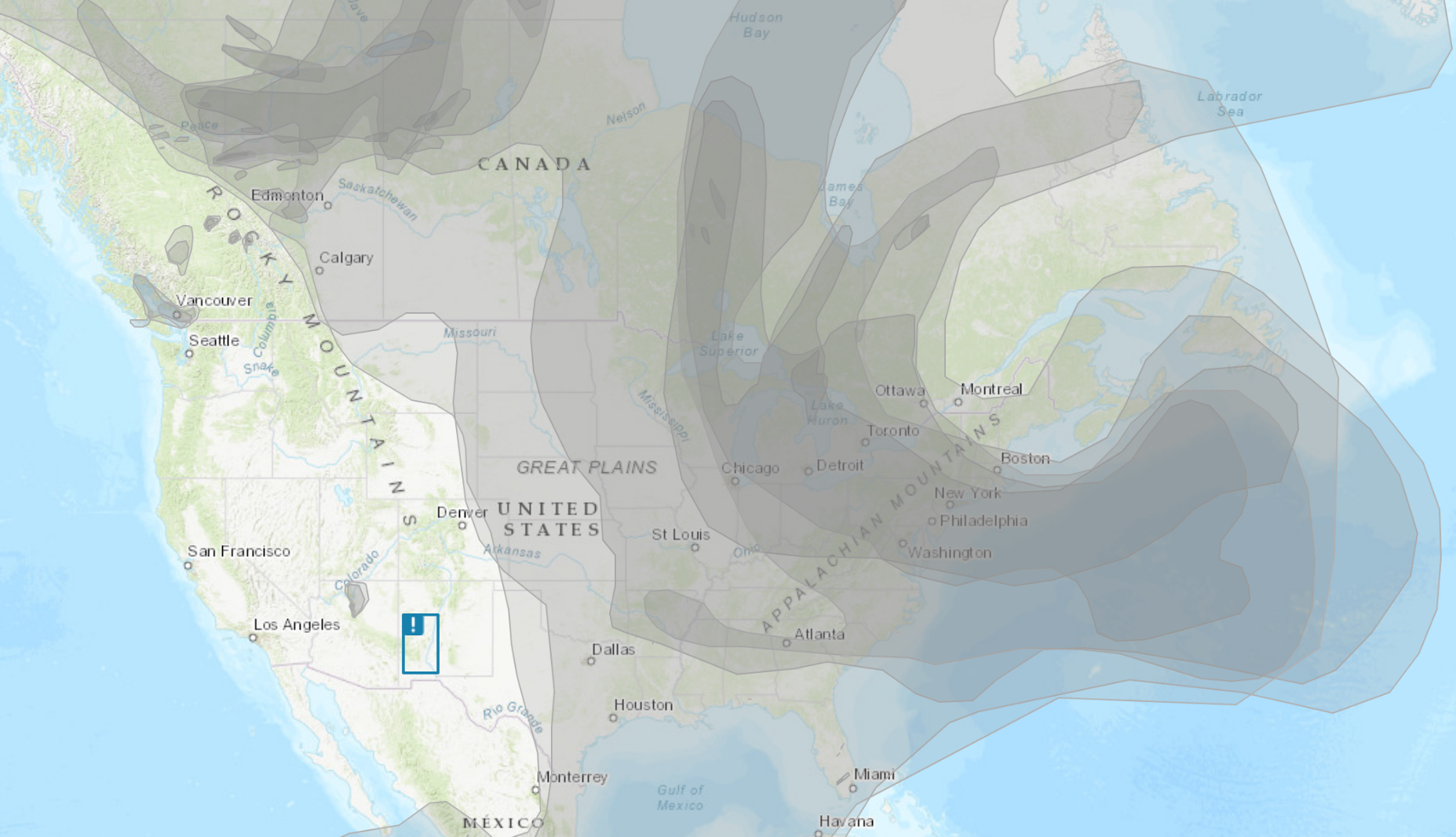
If this early summer will be remembered in history it will be due to the dry, smokey weather and air quality alerts. We generally thank Canada for cool clean air and safe environments, but this year not so much. Below is the smoke plume map which is mainly coming from our neighbors to the north.
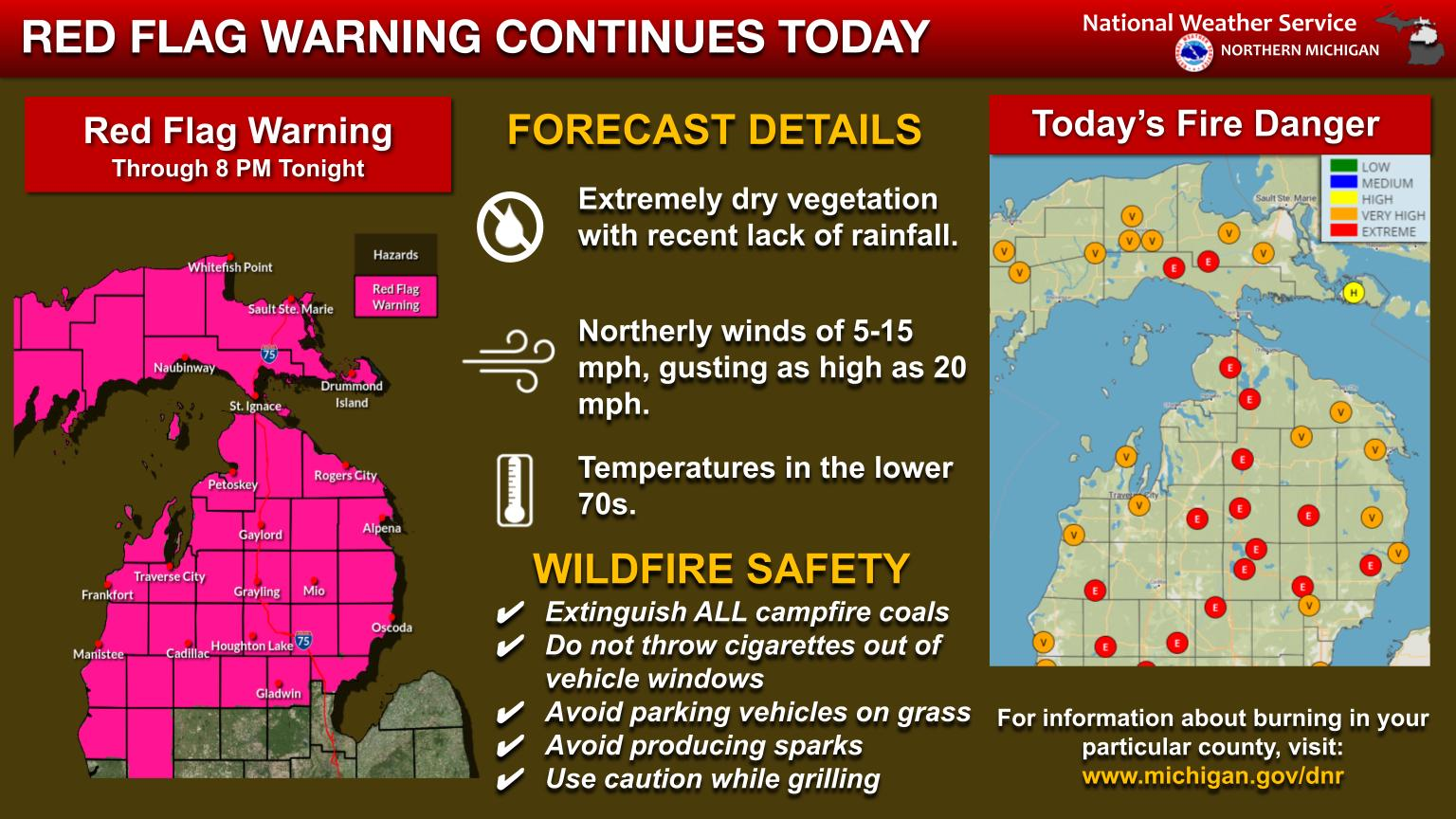
A red flag warning remains in effect for northern lower Michigan through 8 pm tonight. Continued lack of rainfall and extremely dry vegetation across the region will perpetuate favorable wildfire conditions into the end of the week.
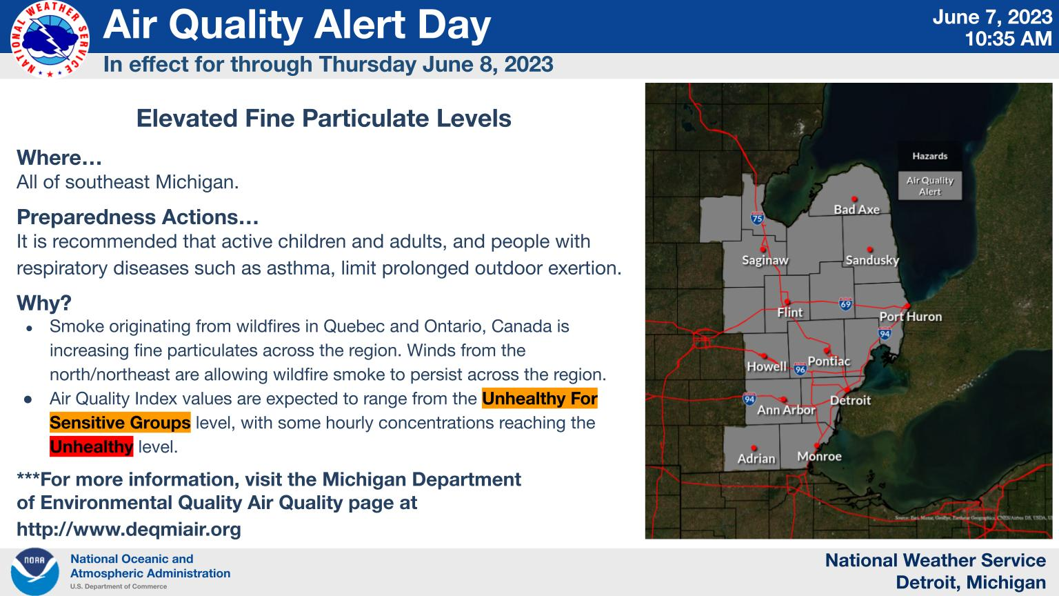
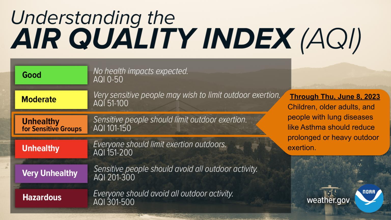
An Air Quality Alert is in effect through Thursday, June 8th for all of southeast Michigan due to increased fine particulates caused by wildfire smoke in Quebec and Ontario, Canada. The Air Quality Index will range from Unhealthy For Sensitive Groups to Unhealthy. It is recommended that active children and adults, and people with respiratory diseases such as asthma, limit prolonged outdoor exertion.
Michigan has declared an Air Quality Action Day through Thursday, June 8th for parts of Southern Michigan due to smoke particles from wildfires in Canada. People with vulnerable lungs are encouraged to limit outdoor activities.
U.S.A and Global Events for June 8th:
1951: A tornado was captured on motion pictures for the first time in the USA. Click HERE for more information from a weather history blog. You can view an image of this tornado by clicking the link HERE.
2001: Tropical Storm Allison hits Houston, Texas, for the second time in three days. Louisiana and southern Texas were inundated with rain. Baton Rouge received 18 inches over just a couple of days. Some portions of Texas racked up 36 inches by June 11. Click HERE for more details from the NOAA Satellite and Information Service.
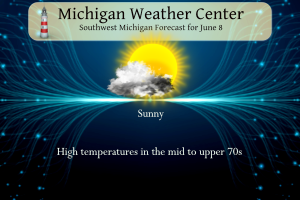
Grand Rapids Forecast
6 8 grrForecast Discussion
.SHORT TERM...(Today through Friday)
Issued at 351 AM EDT Thu Jun 8 2023

- Smoke -

The HRRR smoke model zoomed into the Chicago-Detroit zone shows
quite a bit of smoke in place today when looking at vertically
integrated smoke off the 05z run. So, we are expecting a very
hazy sky with fairly opaque conditions. Near surface smoke is seen
to come a go a bit through the day, so expecting 4 to 7 statute
mile visibilities in haze. The hourly AQI in Grand Rapids at 100am
was 171 which is quite high. We smelled smoke in Grand Rapids
yesterday afternoon and evening and that may occur again today.
Can see things getting worse for us tonight into Friday as both
new fires have cropped up north of Lake Huron and the flow goes
more northeast. Therefore, the fires both in Northern Ontario and
in Quebec will be pushing smoke our direction. Haze will continue
as will unhealthy air. An Air Quality Alert is out for portions of
the area already.

- Mainly dry conditions -

We had a bit of a surprise shower yesterday evening drift south
through the CWA. This was not a surprise to the HREF though which
is the gold standard for quite a few things but certainly
convection forecast. The 4hr max reflectivity showed this shower
nicely off the 12z run. Tonight`s 00z run shows some convergence
and the potential for a few showers in our northeast CWA up
towards Mt. Pleasant and Alma. At this point have maintained a dry
forecast but we will be keeping an eye out for a few showers in
our northeast and eastern CWA.

Otherwise dry and near normal temperatures today through tomorrow.


.LONG TERM...(Friday night through Wednesday)
Issued at 351 AM EDT Thu Jun 8 2023

- Dry weather through Saturday afternoon -

Sfc ridging will result in fair wx through Saturday afternoon. The
elevated fire risk will continue given antecedent very dry
conditions across our area. Temperatures through then will be
seasonable for this time of year.

- Chance for showers Saturday night through early next week -

The wx pattern will become a little cooler and unsettled Sunday
through Tuesday as an upper low closes off over our region. Several
upper disturbances pinwheeling around the upper low will bring
relatively best chances for showers through the period. Instability
continues to look weak but isolated convection is possible as a
result of weak instability and diurnal heating.

Latest GEFS/ECMWF ensembles support potential for three quarters of
an inch to an inch of rainfall from Sunday through Tuesday. A
gradual trend upward a bit in ensemble qpf has been noted the past
48 hours which seems reasonable given the evolution of the upper
level pattern.

However a very large variability in rainfall amounts across our area
is expected given this type pattern. Rainfall amounts could range
from under a quarter of an inch in some spots to around two inches
or greater where rain showers are heaviest/most persistent.
Low to mid 40’s tonight! Serious June cold! Wow, just wow, WOW!
I love cool and quite summers! Keep it rolling!
Slim when was the last time GR had a thunderstorm?? Storms seem to be a thing of the past now forecast smoke coming crazzy …INDY
Temps over 100 degrees in Siberia?? I hope that’s not headed this way.
https://www.cnn.com/2023/06/08/asia/heat-wave-siberia-climate-intl/index.html
That’s crazy! Frozen tundra no more.
Maybe? Please?
Latest GEFS/ECMWF ensembles support potential for three quarters of
an inch to an inch of rainfall from Sunday through Tuesday. A
gradual trend upward a bit in ensemble qpf has been noted the past
48 hours which seems reasonable given the evolution of the upper
level pattern.
However a very large variability in rainfall amounts across our area
is expected given this type pattern. Rainfall amounts could range
from under a quarter of an inch in some spots to around two inches
or greater where rain showers are heaviest/most persistent.
The smell of smoke is now in the air at my house. First time I’ve actually smelled it.
We smelled smoke at sunset last night. Bummer we need to keep the house closed up. The AQI here currently is 174 – roughly +40 from yesterday, which is not good at all. At least we’re not in Pennsylvania this morning. I’m seeing areas in the high 300s and a couple over 400.
I smelled it around then as well.
NY is very interesting, libraries are all opening an hour later and brining any outdoor activities indoors, but things may change…
This is quite a bizarre weather pattern. We had one of the longest stretches of 90s this early in the season, one of the longest dry spells ever, constant wildfire smoke, and a near-constant east wind.
Im looking forward to the rain… let’s hope Canada gets some rain too
What do ya know more smoke on the way:
“The hourly AQI in Grand Rapids at 100am
was 171 which is quite high. We smelled smoke in Grand Rapids
yesterday afternoon and evening and that may occur again today.
Can see things getting worse for us tonight into Friday as both
new fires have cropped up north of Lake Huron and the flow goes
more northeast. Therefore, the fires both in Northern Ontario and
in Quebec will be pushing smoke our direction.”
I know a lot of people think this is a very boring weather pattern. But in fact we are in one of the longest dry spells in Grand Rapids history. And it it also one of the longest periods of smoky skies we have had in a long time. Remember this is just a weather pattern and it like all the weather patterns we have will change.
Slim
The days smoke and dryness continues. Yesterdays official H/L was 77/47 there was no rain fall and 83% of highly filtered sunshine. There were 3 HDD’s and 0 CDD’s. The overnight low here in MBY was 48 the official overnight low looks to have been 50. For today the average H/L is 78/56 the record high of 97 was set in 1933 the record low of 38 was set in 1949 and 1998. The record rain fall amount of 2.32” fell in 1974.
Slim
The next 2 days continue to look very dry with highs around average and lows below average. The is a good chance of some much-needed rain on Saturday night and Sunday into Monday. Saturday should be the warmest day for the next week. It will turn cool for Sunday until Tuesday.
Slim