We have yet another hot and humid day in store with temperatures pushing to near-record territory. Yesterday we reached 88° with dewpoints in the low 70s. Heat indices will be in the mid to upper 90s today with an afternoon isolated thunderstorm and scattered thunderstorms for Wednesday, followed by cooler and less humid weather for the end of the week.
SPC Outlook

Thunderstorms associated with marginally severe winds will be possible on Wednesday from parts of the mid-Mississippi Valley north-northeastward into parts of lower Michigan. A potential for hail is also expected in parts of the mid-Mississippi and lower Ohio Valleys.
Grand Rapids Forecast
9 5 grrU.S.A and Global Events for September 5th:
1666: The Great Fire of London started on September 2nd and continued through September 5th. The fire spread rapidly due to strong westerly winds. This fire consumed 13,200 homes, 87 parish churches, and St. Paul’s Cathedral.
1929: Early season snowfall occurred in the mountains of Wyoming and the Black Hills of South Dakota on September 5th and 6th. The highest snowfall amount was 16 inches in Fox Park, Wyoming.
1933: A Category 3 hurricane made landfall on South Padre Island, Texas during the late evening hours on September 4th or Labor Day. The storm caused 40 fatalities and nearly $17 million in damages. With the storm making landfall during a holiday weekend, fatalities could have been much higher. The following is from the report of the official in charge at Corpus Christi, Texas: “Probably never before in the history of Texas hurricanes have such widespread and early warnings been given as were received from Washington in advance of this one. The telegram of Saturday, September 2, warning all persons to avoid inaccessible places over the weekend probably saved thousands of lives.”
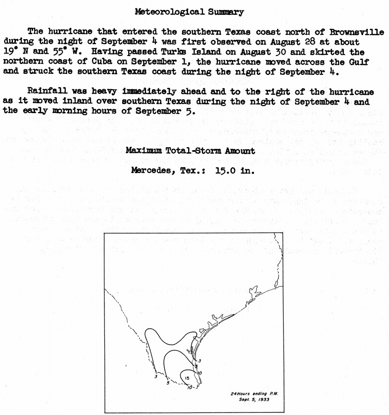
The image above is courtesy of the National Hurricane Research Project, Report No. 3, Rainfall Associated with Hurricanes, published in 1956.
1950: Hurricane Easy was an erratic and unpredictable hurricane that lingered over the Tampa Bay area for days, dropping torrential rains and causing damage, especially in Cedar Key, Florida where the storm eventually made landfall. This hurricane dumped 38.7 inches of rain in 24 hours in Yankeetown, a record for the U.S. at the time, and caused $3.3 million in damage. Total rainfall amounts in Yankeetown was 45.20 inches. Click HERE for more information from the Weather Prediction Center.
1978: Tropical Depression Norman became the most recent tropical system to make landfall in California near Long Beach as an extra-tropical storm.
1996: Hurricane Fran made landfall near the tip of Cape Fear, North Carolina with maximum sustained winds near 115 mph on the evening of September 5th. Fran was responsible for 26 deaths and was at the time the most expensive natural disaster ever in North Carolina’s history. Click HERE for more information from the NWS Office in Wilmington, North Carolina.
2017: Hurricane Irma became a category 5 hurricane with maximum sustained winds of 180 mph. This made Irma one of the strongest hurricanes ever observed in the open Atlantic Ocean. Click HERE for more information from the NWS Office in Tallahassee, Florida.

Forecast Discussion
Our focus in the short term will be on the heat expected for today,
along with shower/storm trends from this afternoon through the end
of the short term Wednesday evening.

The thinking remains the same as it has been for the last few days
with regards to the heat. Much of the area should see temperatures
max out in the lower 90s this afternoon as 850 mb temperatures
remain up toward 20C, with better mixing expected today. We continue
to expect that dew points will rise to the mid 70s F by this
afternoon. These values will yield heat indices in the mid to upper
90s, which is just a little shy of our 100 F thresholds for Heat
Advisories.

What this heat and humidity will do is supply better instability for
the potential of a few showers and storms beginning as early as this
afternoon. HREF mean MU CAPEs are forecast to approach 2,000 J/kg
this afternoon given the temps in the 90s and dew points in the mid
70s. The hires models and CAMs indicate that isolated to scattered
coverage will occur near and east of the lake breeze/shadow. This is
due to the somewhat stabilizing effects from Lake Michigan, and the
divergent flow immediately downwind of the lake. Severe weather is
not likely given deep layer shear values below 20 knots.

The diurnal convection will die off toward sunset this evening,
giving a few hours of dry weather for the entire area much of the
night. Then toward daybreak on Wednesday, we will see rain chances
increase from West to East. There are a couple of features driving
these chances. The first is the upper low/wave that is lifting NNE
toward the area, and the other is a low level jet trying to nose
into the area ahead of the low over the Plains.

The wave lifting toward the area will be continuing to shear out,
and will not be nearly as strong as it has been over the south. The
low level jet expected to support showers and storms over WI and IL
tonight will weaken quickly as it tries to move in. It does seem
that we should see a decent coverage of rain pushing through the
area on Wed morning. Instability on the wane and during the min
diurnal instability will really limit the strength of any storms
that survive.

It does look like there will be redevelopment of showers/storms
Wednesday afternoon. The most likely place for this redevelopment
will be further east for a couple of reasons. First, the further
east areas will have a less chance of early rain stabilizing the
atmosphere as the low level jet fades. The other reason is that with
the approach of the next upper low from the Plains, a new low level
jet will be ramping up to our east which will help to focus the new
development. These storms will have the best possibility of becoming
somewhat strong given the time of day being favorable and good
instability. We do agree with the marginal risk the area has been
placed in by the SPC, as the shear remains on the weaker side with
values around 20 knots.

Additional showers/storms will be possible across the west with the
main low slowly meandering into the area. Scattered showers and
storms will be present, but without a good push from this low,
severe weather does not look to be likely.
What a summer – below normal temps and now another extended stretch of below normal temps! Incredible!
Soak it in…another six months of Winter is incoming.
Bring it on! Who wouldn’t want snow in the winter?
92 degrees with a 70 dew point, yuck. This Summer is winding down the same way it started, hot and dry. The yard has gone from green to half brown in just a few days from this heat. Hope we get some rain, but not looking good for here.
— Evening showers and thunderstorms — The lake shadow we were expecting has formed from Grand Haven to Cadillac and points to the west of that line. Little in the way of cumulus has formed in that zone due to less instability and divergent surface flow. A bit unexpected is a longer time for convection to develop east of that line. The reasoning seems very much tied to the lack of a trigger aloft or a focus in the low levels. The trigger aloft is working in from the south in the form of a shearing out upper low. The… Read more »
it is now 90 degrees with a dewpoint of 75 (whew)
The damage cleanup continues in Portland. I really wish people could have seen the real scope of what happened here. I reached out to NWS Grand Rapids but no one seems to care. Really is disappointing. No doubt feel forgotten about around here. The area from just west of Portland down through northern Eaton County was absolutely raked by that storm.
SUMMERS 23 LAST DANCE!! But then again Summer 23 wasn’t nothing compared to some Summers past no real long heat waves and hardly any humidity its was a great one I will say!! Get ready for highs in the 60’s and 70’s with possible 50’s next week more fires and hoodiee weather to come wow to the wow!! InDY
Rock on Indy and keep the facts Rocking!
Get ready for another stretch of below normal temp days! Who would have thought!
We’ve had a below normal temp summer in GR this year, along with plenty of rain and sun! Fantastic summer!!!
For June/July/August, GR was: 0.9 degrees below average, 0.96 inches below average in rain, 4% below average in sun. Of course this takes into account the early summer heatwave and drought… so June 21-Sept 21st would probably be rainier than this
We’ve had a lot of hot weather around the holidays this year and more than our share of 90 degree days. Had the family over yesterday, grilled outside but we all ate inside with the AC, just to hot to be outside.
Nathan stated that he thought that there have been a lot of hot Labor Days recently. I checked to see if that was the case. Here is what I came up with. Here are the H/L for each Labor day since 2010 at Grand Rapids. 2023 90/69, 2022 71/58, 2021 76/55, 2020 77/61, 2019 80/59, 2018 83/39, 2017 81/57, 2016 86/57, 2015 85/72, 2014 81/67, 2013 73/61, 2012 89/62, 2011 65/49 and 2010 74/59. Of course the dates have range from September 1st 2014 to September 7th 2020, 2015.
Slim
With a official H/L 90/69 yesterday was the warmest September 4th at Grand Rapids since 1948. There was no rain fall and the sun was out 90% of the possible time. The highest wind gust of 23 MPH was out of the SW. For today the average H/L is 78/57 the record high of 92 was set in 1922 and 1954. The record low of 39 was set in 1950 and 1974. With a forecast high of 92 we could be seeing a near record high for today. The warmest minimum is also in play for today the current reading… Read more »