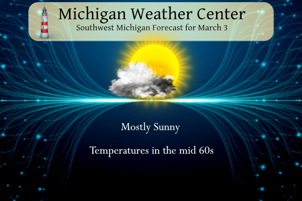
We have expectations of our warmer-than-normal temperatures ramping back up today continuing through the rest of the week. Today will be in the mid-60s and tomorrow in the low 70s before falling back into the 50s on Wednesday. Chance of showers and thunderstorms move in tomorrow and tomorrow night.
February Summary
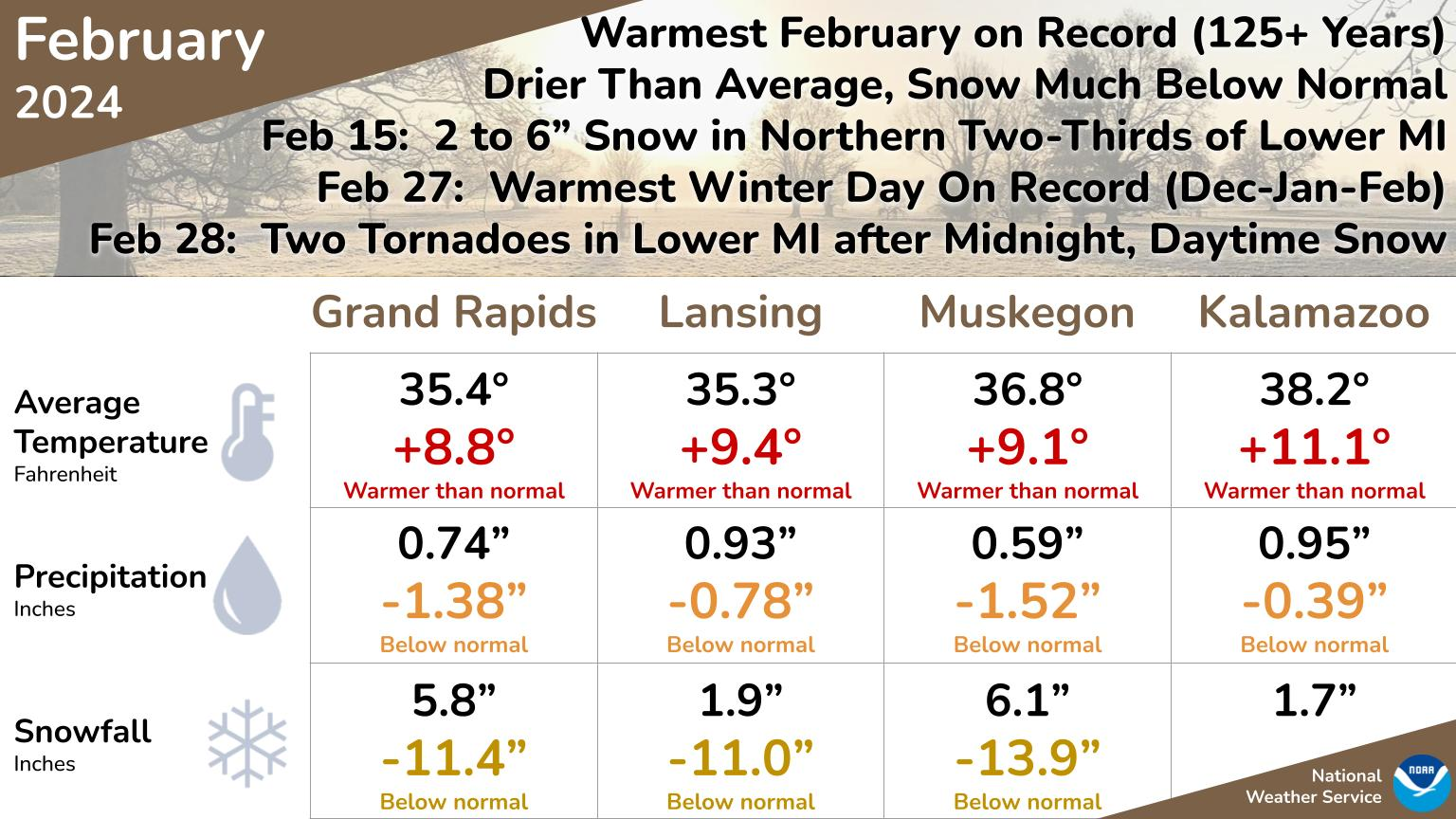
February 2024 was the warmest in over 125 years of record for most of West Michigan, taking the title from 2017. February 27th of this year was the warmest day recorded in any December, January, or February, as highs reached the lower to mid-70s in much of the area. Echoing 2017, the late-month warmth was followed by thunderstorms and tornadoes in Lower Michigan. There were a few days with a minor amount of snow, and just one day provided a quick-hitting 2 to 6-inch accumulation except in far southern Michigan.
Winter Summary
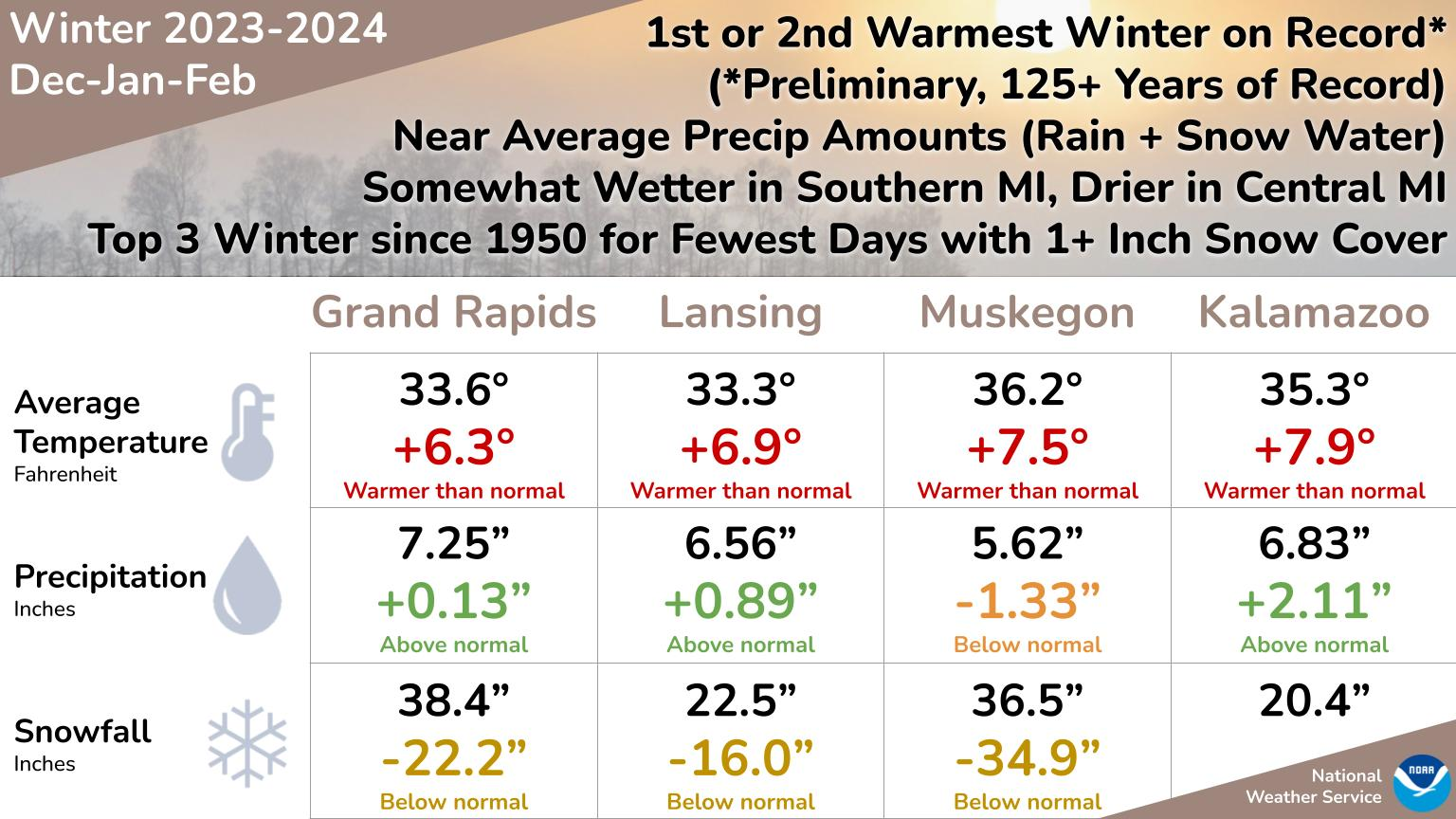
The months of December, January, and February combined make up climatological winter. This winter was one of the warmest among more than 125 years of keeping records. This winter had both the 2nd warmest December and the warmest February. Snowfall was also much below normal, and as a result, the number of days with an inch or more of snow on the ground was near record few. Only 2 weeks in mid-January had prolonged cold and substantial snow.
NWS Forecast
Weather History
1943: Arctic air dominates the first ten days of the month. Record cold temperatures this morning include the 10 below zero at Muskegon and the 9 below at Grand Rapids.
1983: Record highs are set across Lower Michigan with Grand Rapids hitting 72 degrees and Muskegon 69 degrees. The first week of March is incredibly balmy with six straight days of high temperatures of 60 or above at Grand Rapids.
On March 3, 2023, a significant winter storm impacted the area with snowfall rates of 2 to 3 inches per hour at times. Temperatures near or above freezing resulted in heavy, wet snow that piled up quickly and caused additional damage to trees and power lines that were already stressed from several winter storms in a couple of weeks before this event. 200,000 customers lost power and widespread snow totals of 8 to 11 inches were observed. Daily snowfall records were set or tied at all three climate sites: Detroit – 6.2 inches (previous: 6.0 inches from 1875); Flint – 4.9 inches (previous 4.9 inches from 1954); Saginaw – 2.5 inches (previous: 2.3 inches from 2015).
On March 3, 2014, Flint set a new record for its coldest temperature ever recorded in the month of March. The temperature fell to -16 degrees. Meanwhile, Detroit only fell to zero degrees while a temperature of -6 was observed in Saginaw. Neither were records.
Also on March 3, 2002, the coldest temperature of the season hit Detroit with a reading of -4 degrees.
1896: The temperature in downtown San Francisco, California, fell to 33 degrees, which was the lowest ever for the city in March.
1966: An F5 tornado, which would become known as the “Candlestick Park” tornado, named after a shopping center in south Jackson, was destroyed by the tornado. One of only two documented F5 tornadoes to strike Mississippi in the 20th century. The worst damage occurred in parts of Hinds, Rankin, Scott, and Leake counties, where 57 people were killed and over 500 were injured. Click HERE for more information from the NWS Office in Jackson, Mississippi. Click HERE for a YouTube video from the Weather Channel.
1991: A significant ice storm coated parts of central and northwestern New York State with up to two inches of ice. The damage totaled $375 million. It was the most costly natural disaster ever in the state up until that time. Nearly half a million people were without power at the height of the storm, and many would not see their power restored until the 16th.
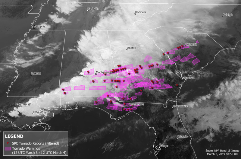
2016: A deadly severe weather event affected the Southeastern United States on March 3, 2019. Over 6 hours, 41 tornadoes touched down across portions of Alabama, Georgia, Florida, and South Carolina. The strongest was an EF4 tornado that devastated rural communities from Beauregard, Alabama, through Smiths Station, Alabama, to Talbotton, Georgia, killing 23 people and injuring at least 100 others. Click HERE for more information from the NWS Office in Birmingham, Alabama. Click HERE for more details from USTornadoes.com
Forecast Discussion
- Patchy Fog Early Becoming Breezy and Mild Sunday

Mostly clear skies and light surface winds could lead to areas of
fog/stratus tonight, especially near the US131 corridor, as south-
southeast winds advect moisture into West Michigan under an
inversion. There is some uncertainty given the presence of 15-25
knot winds in the lowest 1kft which could limit the extent. Any fog
and or stratus that does form will mix out later this morning ans
winds increase,

As mixing increases, breezy conditions are expected with gusts
topping out in the 25-35 mph range this afternoon. Isolated gusts
near 40 mph are possible in the NW CWA towards evening but given the
warm air advection pattern in place confidence in this is lower. The
robust warm air advection occuring also causes 850mb temps to rise
into the lower teens C, translating to mid 60s high temps at the
surface.

- Increasing clouds and Chance of Showers/Storms Into Monday

Clouds then increase Sunday night into the day on Monday as moisture
and warm air advection increases with lower Michigan sitting firmly
in the warm sector of an approaching low pressure system. A 20-30
percent chance of showers exists Sunday Night across the NW part of
the forecast area as the warm front lifts north. Showers and
thunderstorms are again possible ahead of the cold front Monday
afternoon as LI values go negative with more widespread
precipitation Monday night.

Also, is it will feel like May on Monday with highs around 70
degrees. Given moisture advected in with the warm air, dewpoints
Monday will be in the 50s. Multiple high temperature records could
be tied or broken. The Climate section contains more information
on the records as they currently stand.

-Showers Monday night/Tuesday, then cooler

The going forecast is largely on track with high confidence for rain
Monday night and Tuesday along with scattered thunderstorms.

As Monday night begins, a cold front will stretch from near the
Straits southwest to western IL. Low pressure riding northward along
the front will generate showers and storms from Missouri into
Wisconsin. The best instability with this front will remain south of
the state, but mid-level lapse rates around 7c moving into the cwa
during the evening will result in 400-600 j/kg MUCAPE; enough for
some storms to develop. The 45kt LLJ will also nose into the cwa, so
moisture transport will be in place. The frontal boundary will
provide enough lift to get a few storms going. Given meager CAPE
values, coupled with bulk shear in the 25-30kt range, severe storm
probabilities will be low. QPF in the 0.5 to 0.75 range will provide
much needed relief from the abnormally dry conditions across the
cwa. Precipitation will gradually spread east throughout the night
and exit the cwa Tuesday morning; we`ll likely see some sun by
Tuesday afternoon.

Temperatures will be cooler...but still above normal...Tuesday
through the weekend with highs in the 50s Tuesday-Friday, before
falling into the 40s during the weekend.

-Increasing confidence for rain Friday/Saturday

Models have been showing northern and southern stream waves moving
across the center of the country and phasing as the near the Great
Lakes. Once this occurs, we`ll likely see cyclogenesis over the Gulf
Coast which will then move northeastward toward the southern Great
Lakes and Ohio Valley. The inverted nature of the trough suggests we
could see strong moisture transport from the Gulf and another round
of decent rainfall; the ECMWF ensembles point toward similar QPF
Friday as what we expect Monday night/Tuesday.
.CLIMATE...

Strong southwest winds will push warmer air into Lower Michigan
Monday resulting potentially in record highs.

Records for March 4

GRR.....66 - 1983
LAN.....64 - 1894
MKG.....62 - 1992
AZO.....72 - 1974
Plenty of mid 50’s to 60’s in the 2 week forecast! Does not get any better than this for this time of year!
https://weather.com/weather/tenday/l/52aab230ef88e4f2bb12857231a5dd58392e78a71b90e01d57a11d827658eb55
As long as it ain’t snowing next weekend, I’m happy!!
Get ready – next weekend highs only in the 4o’s!
Doing some spring cleaning around the yard and my peonies are popping up. Insane.
Slim was right on point too, with the snow totals!
Slim
I am sure it will snow between now and the end of April. A heads up in the past winters when there was very low snowfall totals in November and December the mean snowfall for the winter season was 43.8″ So if we have less than 9″ total snowfall by New Years this winter could end up with a total snowfall of less than 45″ remember this is not a forecast it is just going by past winters with little snowfall before the new year.
Slim
December 12, 2023 3:31 pm
Looks like I called it this year Mookie!
Andy W
I believe the best winters start in mid January and last for a few weeks just like this past year! We’re at 3 inches of snow TOTAL for this winter so far LOL!! With no change in sight! WOW!!!
December 26, 2023 4:10 pm
Best winter ever!! Let’s have another like this next year!
More record temps? Wow! I love short winters!
Absolutely one of the worst winters ever! Hopefully we get plastered next winter! That would be awesome!
Winter is dead! You were completely wrong!
Those are some impressive numbers for the February and Winter stats! Easiest and best Winter ever, I just hope it doesn’t lead to a Summer that’s 10 degrees above average.
Last winter was one of the warmest ever and the summer was pretty average. But that’s just one year, not sure what the typical correlation is… if I had to guess, probably not much (hopefully!)
Also last summer was very weird. We had the huge drought and heatwave, then the wildfire smoke… let’s hope it isn’t a repeat of that
I don’t see any reason to think that this summer will be that warm. In fact I would not be too surprised to see a cooler than average summer.
Slim
A good summery from the NWS and points out what I had stated before. That this past February was the warmest on record and at Grand Rapids the meteorological winter was the 2nd warmest on record. For the season so far Grand Rapids has only had 40.3″ of snowfall that is -28.5″ at Lansing 24.8″ -18.6″ and at Muskegon 49.7″ -29.1″
Slim
The official H/L yesterday was 54/38 that 54 was the 5th warmest for the date and the 38 was the 2nd warmest minimum for the date. There was no rain/snowfall. The sun was out 78% of the possible time. For today the average H/L is 39/23 the record high of 72 was set in 1983 the record low of -9 was set in 1943 the wettest was 1.32” in 1941. The most snowfall is 5.0” in 2007 the most on the ground is 19” in 2014. Last year the H/L was 34/28 and there was 2” of snowfall.
Slim