My wife and I were married on March 2nd many years ago, it was memorable because we had a lake-effect snowstorm with a lot of wind to contend with. We were married at the Christian Reformed Church in Plainwell I had attended since the early 1960s with a brief break in the early 70s when I moved to Maine for a few years. March is well known for a wide variety of weather from snow storms to thunderstorms. Below is the national weather history for March 2nd. The first photo is similar to one my grandfather had from the 1930s.
March 2, 1966:
The blizzard began late on March 2 in the west and moved very slowly across the state, reaching the extreme east on the 4th and continuing into the 5th. Snow depths ranged from 2 to 4 inches in southeast South Dakota to nearly 3 feet in north-central South Dakota. Winds of 40 to 55 mph with gusts to 70 mph caused widespread blowing snow and near-zero visibilities during the storm. Drifts up to 30 feet were reported in sheltered areas with bare open fields. The storm caused massive livestock losses. Estimated losses were 50,000 cattle, 46,000 sheep, and 1800 hogs. The most substantial losses were in the central and north-central parts of the state. The heavy snow also collapsed many structures. The storm directly caused three deaths due to exposure, and three were indirectly caused by the storm; 2 due to heart attacks and one by asphyxiation. The blizzard was rated as one of the most severe that has been experienced in South Dakota. Many roads were blocked for days, and many schools and businesses closed.


March 2, 2007:
An area of low pressure moved slowly northeast across the central and northern plains, bringing widespread snowfall and intense winds. The combination of the falling snow and the existing snow cover resulted in blizzard conditions with visibilities to zero at times. This blizzard event was part of the same upper-level low-pressure trough that brought heavy snowfall to the area on February 28. Additional snowfall occurred across the region on March 1st and 2nd as a large area of snow wrapped in from the east. Widespread blizzard conditions developed by noon on March 2 and continued into the early morning hours of the 3rd. Snowfall amounts, including the snow on February 28, ranged from 2 to 22 inches across central and northeast South Dakota. The heaviest snowfall amounts were across northeastern South Dakota, where total snow depths were in the 25 to 30-inch range. Northwest winds of 30 to 45 mph with gusts near 60 mph brought zero visibilities across the area, creating large snowdrifts. Schools, businesses, airports, roads, and interstates were closed for up to two days. Travel was not advised across the area. Also, many cars were ditched, along with several accidents. Many travelers were stranded, and several shelters were opened. The Emergency Operations Center was activated in Pierre, and the Governor declared the blizzard area a disaster. Some of the most significant snowfall amounts over the 3 days included 11 inches at Andover, Hosmer, and Redfield, 12 inches at Webster, 13 inches at Miller, 14 inches at Victor, Groton, and Clark, 15 inches at Castlewood and Summit, 16 inches at Watertown and Roy Lake, 19 inches at Sisseton, 20 inches at Milbank, 21 inches at Bryant, and 22 inches at Clear Lake.
U.S.A and Global Events for March 2:
1927: Raleigh, North Carolina, was buried under 17.8 inches of snow in 24 hours, a record for that location until 2000. On January 25, 2000, Raleigh saw 17.9 inches of snow in 24 hours.

The snowfall map above is from Eric Webb.

1988: Thunderstorms produced severe weather in the south-central U.S. A tornado in Baton Rouge, Louisiana, injured two persons, and another tornado caused five million dollars in damage at the airport in Lafayette, Louisiana.
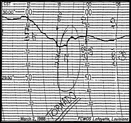
The image above from Storm Data is a barograph trace from the airport in Lafayette, Louisiana. It shows a rapid pressure drop of 0.24 inches as the tornado passed the airport. The tornado, F1 in intensity, traveled only 0.8 miles but caused an estimated $5 million in damages.
2005: Waterspouts were recorded in Redondo Beach in southern California. Pea size hail accumulated to a depth of one inch on Huntington Beach.

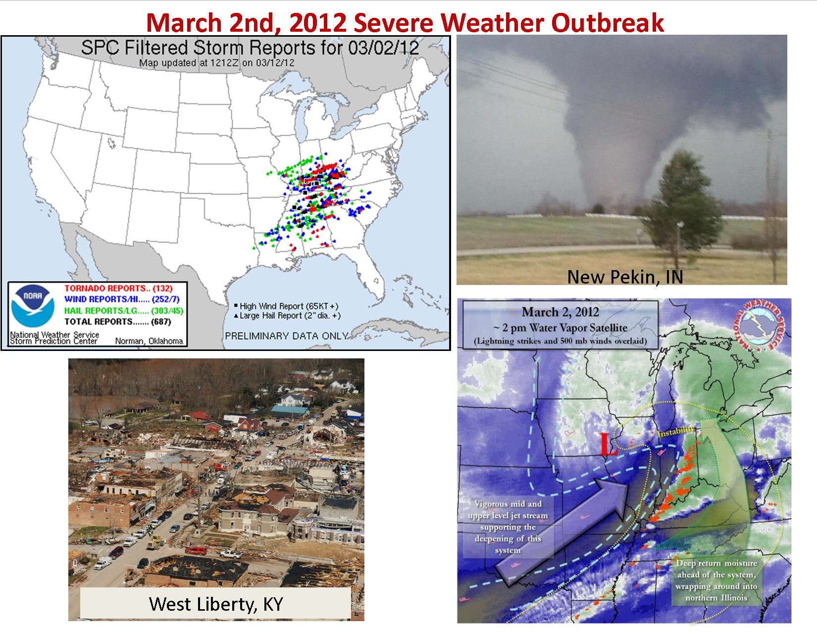
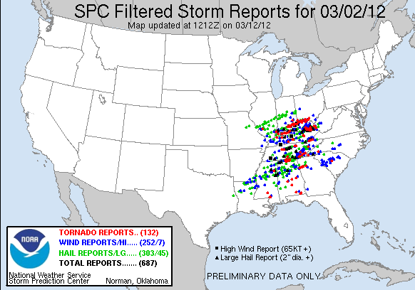
2012: The March 2 and 3, 2012, a deadly tornado outbreak occurred over a large section of the Southern United States into the Ohio Valley region. The storms resulted in 41 tornado-related fatalities, 22 of which occurred in Kentucky. Tornado-related deaths also occurred in Alabama, Indiana, and Ohio. The outbreak was the second deadliest in early March for the U.S. since official records began in 1950. Only the 1966 Candlestick Park tornado had a higher death toll for a tornadic system in early March. Click HERE for more information from the NWS Louisville, Kentucky.
Grand Rapids Forecast
3 5 grrLansing Forecast
3 5 lanKalamazoo Forecast
3 5 kzoForecast Discussion
-- Impactful system possible Sunday night through Monday --

A wide range of solutions remain possible with the upcoming system
moving through the region Sunday night through Monday. The EC and
NAM are trending either rain or snow, with more rain expected. The
GFS is trending colder and has more snow. There are some of the
ensembles, specifically the HREF, that have a line of persistent
freezing rain along a frontal boundary from Jackson to Ludington as
the system moves in Monday morning.  What consensus there is is that
there will be decent QPF with this system with the higher amounts
coming in two different periods.

This upcoming system is steming from a mid level low that will be
moving northward from the Great Plains region, bringing warm air
advection along with it. That warm air will be the differing factor
for precipitation type. There is still some concern that given any
wetbulbing of temperatures that snowfall could still occur,
especially north of I 96.  Currently a mix of rain and snow is
expected early Monday morning along and north of I 96 with mainly
snow expected in Clare, Isabella, Osceola and Mecosta counties.
South of of I 96 and eastward including Ottawa and most of Muskegon
county, the precipitation type should be rain.

As the before mentioned low moves through the Great Lakes region
Monday into Monday night an area of higher precipitation will
develop along its southern boundary, mainly in between the I 96 and
I 94 corridors and should be rain.

As the low exsists there is a chance of a bullsyse of QPF on the
backside of an uppe rlevel trough swinging through behind the low.
This could couple with colder air to allow for a blast of snowfall
through northern Lower, and northern central Michigan. There remains
some timing and intesity issues.

 Expect precpitation to cease as the low advects to the east Tuesday
morning.


--Rebounding temperatures and mild weather through midweek--

Though colder air will move into the region Monday night into
Tuesday, temperatures will move into the upper 30s to low 40s during
daytime on Tuesday. Michigan will be in primarily drier air which
should lead to mostly clear skies Tuesday and Wednesday. The next
system is expected to move into the region Friday.
MV I hope you and your wife had a wonderful anniversary! We will be celebrating our 53rd this June.
Today was beautiful outside. It didn’t even feel cold this morning. We have lots of robins now and my flowers are popping up. 🙂
MV I hope you and your wife had a wonderful anniversary! We will be celebrating our 53rd this June.
Today was beautiful outside. It didn’t even feel cold this morning. We have lots of robins now and my flowers are popping up. 🙂
What’s the moderation for?
Great news – the CPC continues to hammer us with cold all month! I love long winters!
Look at all this snow in the 10 day! Wow just wow! 90 inches of snow and counting! I have used the snowblower about 5 or 6 times already and more to come! Incredible!
https://www.pivotalweather.com/model.php?p=snku_acc-imp&rh=2023030518&fh=240
Hope you had a great anniversary MV! We’re coming up on our 30th this year.
Brought the snowblower down to the barn yesterday, hasn’t been touched since the one snow event we had in January. Yet another Winter it barely got any use. Heading out to the pickle ball courts his afternoon, perfect playing weather with no wind, warm Spring sun, and temps around 50 degrees.
Next weekend our days will seem longer ..we spring ahead!! Any snow from here on out won’t last long. (My Dad always said that after we’d spring ahead and then proceeded into the age old debate of keeping the time….every year.) Lol
I hate the time change and the data is clear it is bad for your health! One of the dumbest things we do as a county! Ridiculous!
I really like it when it stays lighter out a little later.
By the end of next week we will be seeing highs in the low to mid 30’s with snow chances! Sure feels like a long winter that will be hanging on for many more weeks!
Mid to upper 40’s today with no snow on the ground. Rain tonight and tomorrow. Sure feels like early spring.
Happy belated anniversary! We will be married 21 years in June. I did not marry when I was young. Had to wait for the right girl.
The sun has that spring feel to it. Took the pooch for walk this morning and the sun feels warm. Didn’t need more than a light jacket. I have a feeling that most of the snowfall from Friday will be gone today.
My friends, have a fantastic Sunday and remember, make someone smile. 🙂
I will piggy back off of Mark’s. I hope you & your wife had a great anniversary!
The recent snow/rain/ice events have out a dent into the eastern half of the state’s moisture deficits. I expect the last storm will improve it even more.
https://droughtmonitor.unl.edu/CurrentMap/StateDroughtMonitor.aspx?MI
SE Michigan definitely needed that snow!
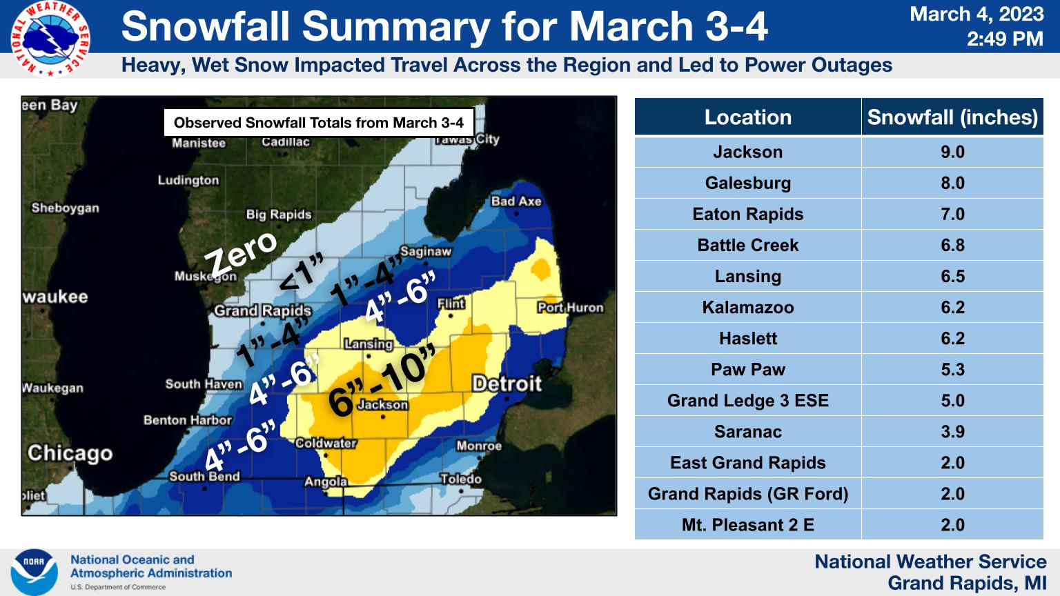
More from NWS Detroit. Incredible March snowstorm!
“Widespread snow totals of 8 to 11 inches occurred along a corridor from Jackson to Howell and Ann Arbor, the northern Metro Detroit suburbs, Lapeer, and parts of St. Clair and Sanilac Counties.”
Agreed and GR just missed this monster snowstorm! But don’t worry we will see more accumulating snow this month!
Watching a potential snow system around the Friday/Saturday timeframe. To early to say if it will impact us or not though. GR is now at 88.8” for the winter.
From NWS Detroit:
“Daily snowfall records for March 3rd were broken/tied at all three climate sites: Detroit – 6.2″ (previous: 6.0″ from 1875); Flint – 4.9″ (previous 4.9″ from 1954); Saginaw – 2.5″ (previous: 2.3″ from 2015).”
Happy anniversary MV and wow some good information on some past early March snow events.
Slim
After the Friday’s snowstorm that was mostly to the south and southeast of GR dropping from just a trace of snow at Muskegon to around 7” at Lansing. Yesterday was a very mile day a here in the GR area all the snow melted. The official HL here in GR was 47/26 there was 0.03” of rain fall late last night. The day started with 2” on the ground at GRR. A half inch here in my yard, a trace at Muskegon and around 7” at Lansing. The overnight low and current temperature here in MBY was 29. There is… Read more »
Yes, tMarch is a winter month and multiple snow events hit us in this Month! Great news – we have plenty more accumulating snow events that will effect us this month! No, winter is not dead! It is alive and well! I will be heading to snow country this coming weekend for a ski trip! Great winter weather is on tap! Get ready!