
Humisery (or humidex as it is known in Canada) is the opposite end of the spectrum as windchill. Aptly named this is a discomfort index derived from the combination of heat and humidity. Some are more tolerant of these conditions than others. It has been my philosophy that one can only take so many clothes off to dress for days like these while in the cooler months one can easily put on more layers of clothing.
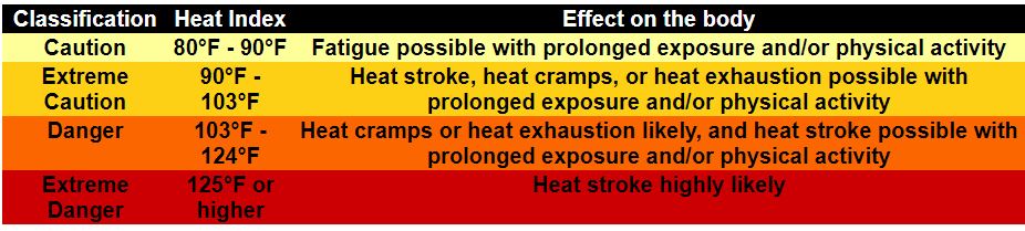
Since the inception of this site, I have had charts for both heat index and wind chill (at the bottom of the page). Below is the Heat Index chart:
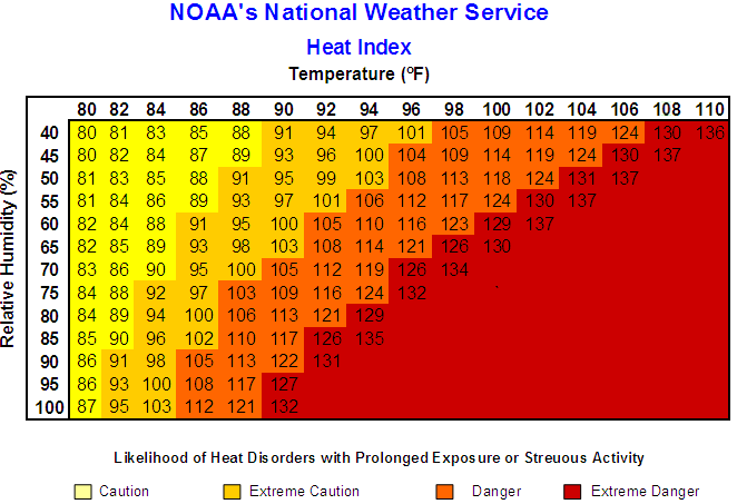
If you are a math nerd here is an equation that gives a very close approximation to the heat index. However, this equation was obtained using a multiple regression analysis, and therefore, it has an error of ±1.3°F.
Heat Index = -42.379 + 2.04901523T + 10.14333127R – 0.22475541TR – 6.83783 x 10⁻³T2 – 5.481717 x 10⁻²R2 + 1.22874 x 10⁻³T2R + 8.5282 x 10⁻⁴TR2 – 1.99 x 10⁻⁶T2R2
T – air temperature (F)
R – relative humidity (percentage)
Our high temp yesterday was 83.8° with a 72.9 dew point. Today is going to be worse in the range of oppressive where one would be best served staying inside in front of the air conditioner or in a pool of water or lake if outside. With air temps today near 90° and dewpoints in the low 70s it will seem quite tropical. The humidity will stick around through at least mid-week.
There are showers and storms currently moving from Grand Rapids to the north. Areas to the south should remain dry today with rain chances around 20% mainly this morning. Rain chances increase as we move into Monday and Monday night with a more active pattern persisting into Thursday.
| Sunrise Today: | 6:41 am↑ 67° East |
|---|---|
| Sunset Today: | 8:54 pm↑ 293° Northwest |
SPC Day 3 Outlook
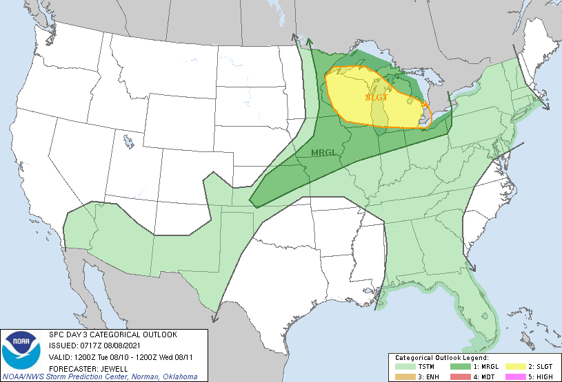
Storms are likely to develop near the primary cold front, with wind and hail threat and sufficient SRH may exist for supercells. Focus for other storms away from the front is more uncertain, but heating will likely lead to clusters of storms from WI into Lower MI during the afternoon. Extreme instability, including steep midlevel lapse rates, suggests significant wind potential. Parts of this region may be upgraded further in later outlooks as predictability increases.
Forecast Discussion
--Morning storms north today, then hot and humid--

Swly low level jet of around 35 kts stretching from Iowa to west
central Lwr MI and PWATs around 1.8 inches will help to fuel more
showers and tstms this morning, mainly north of a Holland to
Lansing line. Some locally heavy rainfall is possible,
particularly around MKG where several hours of training appears
possible based on regional radar trends.

The west-east oriented frontal boundary that the convection is
riding along early this morning will lift north today, which
should lead to a diminishing trend to the convection toward
afternoon. There is also H5 shortwave ridging/subsidence
developing this afternoon and evening downstream of the digging
Central Plains shortwave, furthering the notion of limited
convection from 18Z today through much of tonight.

As high temperatures push toward 90 this afternoon inland from Lk
MI with lower 70s dewpoints in place, the heat index will reach
oppressive values in the mid to perhaps upper 90s. Fortunately a
decent breeze will be present with some gusts to 25 mph.

--Storms likely Monday with locally heavy rainfall--

Good set up for numerous to widespread showers and tstms on
Monday afternoon into Monday night as a pronounced mid level
shortwave trough drags slowly east through the region and
interacts with a very moist air mass (PWATS near 2"). Slow moving
showers and tstms will likely contain torrential downpours making
localized flooding possible - especially if heavy rain persists
over urban areas. Svr wx threat is relatively low Monday due to
limited shear, but it is not zero. Main threat would be for
localized strong wet microburst gusts.

--Active pattern/high humidity persists through Thursday--

Pattern remains unchanged through much of the coming week, with
high PWAT air remaining in place and uncomfortable conditions
persisting. A daily convective threat will remain, enhanced at
times by shortwaves or MCVs riding east through the zonal flow
aloft and occasional ramp-ups of the low level jet. Main threats
will continue to be locally heavy rain/flooding as well as
pockets/corridors of gusty winds from any more organized
convective clusters passing through. Arrival of cooler drier air
mass is still progged for Friday into next weekend, ending the
threat of convection and ushering in more comfortable conditions.
91*’ Degrees 101* heat index and a dewpoint of 74* today around 2pm on Fort Myers beach now we are getting Thunderstorms storms from the heat of the day …..Now that is some heat Slim …..The ice cold Sprites even sweat down here ……..But still no 90’s back home hu?? If that’s the case the streak continues almost 2 months since the last 90* degree day wow have a good rest if the week my friend ….INDY
Yes the warm weather hype is ridiculous and wrong as usual!
Yes grasping for heat indexs or something now ….INDY
The high for today so far looks to be 86 the highest reported dew point at GRR was 75 giving a heat index of 94. At this time it is 86 here with a Dew point of 73. All in all a very warm and humid day.
Slim
I Spent 3 hours outside this afternoon – am now well wilted.
Currently 86.2 with a 75.5 dp – feels-like temp of 96.5
I picked up almost 1 inch of rain last night! Awesome baby!
Good post for today MV, unless of course one doesn’t believe the heat index is in fact a real thing. It is hot and thick out there today! Heat index is already 96 here. Tough day to do anything but stay inside.
Here at my house I recorded 0.17″ of rain fall overnight. The overnight low here was a warm 70. The official low looks to have been 72 but there was only around 0.05″ of rain fall at the airport. At the current time the official temperature is 73 with a DP of 72. Yesterday with a H/L of 84/66 was the 1st day of this August that the mean was above average. After the first 7 days the mean at GR is 69.4 and that is -2.9 for the month so far.
Slim