 July
July
I must wonder just were the time goes as July is just around the corner. This is how an English travel site describes Michigan weather for July.
“July is usually the hottest month of the year in Michigan. The average high temperatures are in the hot 76°F (24.4°C) to 85°F (29.4°C) range, while nights are comfortable in the 50°F (10°C) to 64°F (17.8°C) zone. Temperatures briefly reach 95°F (35°C) in the southeast, with an increase in humidity. Grand Rapids in the western Michigan averages between 62°F (16.7°C) to 83°F (28.3°C), Ludington in the north is between 59°F (15°C) to 79°F (26.1°C).
Camping grounds are full near the lakes as well as the mountains with tourists and locals who gather in peak numbers. The conditions are the best for buggy riding on the dunes near the lakes. Hike the mountains and stay in the lodges while making the most of the warm conditions of summer. Keep an eye on the weather for sudden thunderstorms.
Sweatshirts are suitable for the summer. Rarely does Michigan weather allows wearing a single layer of clothing as in July”
Note I am not sure what they call “mountain” must be in the western UP.
Anyway, the new 30 year average mean at Grand Rapids for July is 72.8 with 3.86” of rain fall. The new 15-year average at Grand Rapids is 73.5 with 3.84” of rain fall. The average 30 year H/L starts out on the 1st at 82.8/61.7 and reaches the warmest of 83.4/62.7 on the 17th and ends the month at 82.5/62.6 the new 15 year average is 82/8/62.0 on the 1st reaching 84.3/63.6 on the 17th and ending the month at 83.6/63.2. The warmest 5 year means in July are 1. 1921*79.7. 2. 2012**79.2. 3. 1916***78.7. 4. 1901****78.1 and 5. 1936*****77.3 The coldest 5 are 1. 2009*67.1. 1992**67.2. 3. 1950***68.1. 4. 1996****68.2 and 5. 2014*****68.4. I was surprised that 4 of the coolest July’s where in the last 30 years. The hottest day was 108 on July 13, 1936. On July 6, 2012 it reached 104 and at my house I recorded 109 that day! The coldest low of 41 was on July 6 1983. The average number of days of 90 or better are 5 the most 90 days in July is 18 in 2012 there have been 11 years when July has had no days of 90 or better the last time was in 2014. The most 100° days at Grand Rapids is 6 set in 1936 there were 4 in 1934 and 1916 2 in 1884, 1897, 1911 and 2012. With 1 in 1898, 1921, 1931 and 1988.
While July has the warmest average mean temperature it is NOT always the warmest month of the year. I was kind of surprised to see so many years when July was not the warmest. June was the warmest in 2014,1967,1956,1971,1984 and 2005. August was the warmest in 1947,1900,1937,1959,1995,1938,1918,1906,1899,2007 and 1984.
So far this year there have been some real up and downs in the temperature department. There have been some real warm days and some real cool days this month so far. On June the departure was -15.7° that is the biggest negative departure on any day in June since a departure of -15.8° on June 6th 1998. The trend for this year has been for some very big temperature swings as (June-15.7, +12.7°) May(-18.4, +19.9) April (-15.8°, +23.9°) have had huge departures of both above and below average. While March had a huge +24.5 day but February had a huge -21.9° departure.
Slim
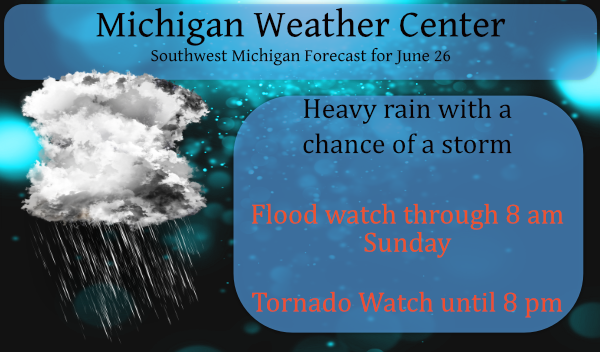
The is the storm outlook from the SPC for today:

Strong to severe thunderstorms will be possible this afternoon and evening. The biggest and most likely threat from all thunderstorms today will be heavy rain and flooding, especially streets and low-lying areas. A few severe storms may develop, and produce damaging winds that could bring down trees and power lines, or even a tornado. The area we are most concerned about for tornadoes is in the yellow shading on this graphic. Please remain aware of changing weather conditions today, and have multiple ways to receive warnings.
Forecast Discussion
- Flood risk continues into Sunday morning

Deep southwest flow will continue to advect a very moist airmass
into the CWA during this time. PWAT values will remain around 2
inches. LCL values will be low and the CAPE thin and deep which
will support efficient rainfall. A low level jet will focus the
development of bands of showers and storms...while aloft
diffluence is noted. This pattern remains largely in place through
the period. It is already saturated from the recent very heavy
rain and streams are rising in many locations. Thus flooding is
possible...especially where any cells repeat over the same area.

- Severe potential today and Sunday

Deep layer shear increases this afternoon as surface based
instability builds. This occurs as another With low lcl`s and
elevated helicity values we will need to monitor the tornado risk
in addition to damaging winds. Models are showing a low level jet
nosing in during the afternoon. Thus a risk for organized
convection is forecast to develop. The main time window looks to
be 18z to 02z. SPC has raised the risk to slight for the day 1
outlook.

We are less confident on the potential for severe weather on
Sunday. We do develop some instability but there appears to be
less focus. Deep layer shear is elevated but the main instability
axis may be south of the CWA.
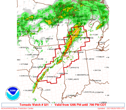 * Tornado Watch for portions of
Central and Northeast Illinois
Northwest Indiana
Southwest Lower Michigan
Lake Michigan
* Effective this Saturday afternoon and evening from 1205 PM
until 700 PM CDT.
* Primary threats include...
A couple tornadoes possible
Scattered damaging wind gusts to 70 mph possible
Scattered large hail events to 1 inch in diameter possible
SUMMARY...Isolated rotating storms have begun to develop over
central and northeast Illinois. This trend may continue through the
afternoon, with the potential for damaging wind gusts or isolated
tornadoes in the strongest cells.
The tornado watch area is approximately along and 50 statute miles
north and south of a line from 35 miles west northwest of Decatur IL
to 35 miles north of Lansing MI. For a complete depiction of the
watch see the associated watch outline update (WOUS64 KWNS WOU1).
* Tornado Watch for portions of
     Central and Northeast Illinois
     Northwest Indiana
     Southwest Lower Michigan
     Lake Michigan

   * Effective this Saturday afternoon and evening from 1205 PM
     until 700 PM CDT.

   * Primary threats include...
     A couple tornadoes possible
     Scattered damaging wind gusts to 70 mph possible
     Scattered large hail events to 1 inch in diameter possible

   SUMMARY...Isolated rotating storms have begun to develop over
   central and northeast Illinois.  This trend may continue through the
   afternoon, with the potential for damaging wind gusts or isolated
   tornadoes in the strongest cells.

   The tornado watch area is approximately along and 50 statute miles
   north and south of a line from 35 miles west northwest of Decatur IL
   to 35 miles north of Lansing MI. For a complete depiction of the
   watch see the associated watch outline update (WOUS64 KWNS WOU1).
Tornadoes all over south and east of us!! Good call by the NWS putting out tornado watches today!
I am going to missed barely… It is hitting hard in Charlotte, but based on track of the rotation icons, we are going to be missed.. Hope it continues on like that 🙂
ADA – 2.3 inches and rising…
That storm near Freeport sure looks interesting. No warning though.
Good call….
Yes I’m surprised there wasn’t a warning earlier, but maybe because there was no debris signature at the time I posted this.
Heavy heavy rain right now!!!
Heavy rain as we speak! It looks like 2 inch per hour intensity! Horrible!
Absolutely horrible, horrendous weather patter! Ridiculous!
…A TORNADO WARNING REMAINS IN EFFECT UNTIL 445 PM EDT FOR NORTHERN ISABELLA…SOUTHERN CLARE AND SOUTHEASTERN MECOSTA COUNTIES… At 346 PM EDT, a confirmed tornado was located near Remus, or 10 miles southeast of Mecosta, moving northeast at 30 mph. HAZARD…Damaging tornado. SOURCE…Radar confirmed tornado. IMPACT…Flying debris will be dangerous to those caught without shelter. Mobile homes will be damaged or destroyed. Damage to roofs, windows, and vehicles will occur. Tree damage is likely. This tornado will be near… Lake Isabella around 405 PM EDT. Rosebush around 430 PM EDT. Farwell around 435 PM EDT. Clare around 440 PM EDT.… Read more »
…A SEVERE THUNDERSTORM WARNING REMAINS IN EFFECT UNTIL 500 PM EDT
FOR ALLEGAN COUNTY…
At 336 PM EDT, a severe thunderstorm was located 7 miles northwest of
Allegan, moving northeast at 50 mph.
HAZARD…60 mph wind gusts and penny size hail.
SOURCE…Radar indicated.
IMPACT…Expect damage to roofs, siding, and trees.
This severe storm will be near…
Allegan around 340 PM EDT.
Other locations in the path of this severe thunderstorm include
Wayland.
Well it is raining once again. At this time it is mostly just a light rain and there has not been any thunder or wind. In fact there are just a few reported lighting strikes over Lake Michigan west of South Haven and that is it so far. It did warm up to 77 here before the rain moved in. It is still a rather mild 75 here with a DP of 74 so there is a lot of moisture to work with.
Slim
Updated post to reflect tornado watch 321
Sadly, I’m at 1.5 inches so far today, with more rain moving in off the lake 🙁 Looks like our “wettest” day.
TORNADO WATCH HAS BEEN POSTED FOR ALL OF WEST MICHIGAN HERE WE GO!! INDY
https://forecast.weather.gov/wwamap/wwatxtget.php?cwa=grr&wwa=tornado%20watch
Silly, bored, lonely NWS Staff….
It is very humid outside. Not raining now.
Thanks Slim. Yeah, not sure where our Michigan mountains are. We have some “hills”. Another inch of rain today so far pushing us over 3” total the last 3 days. Boy is it humid out! Dew point is now 73 and feels downright terrible. Everything in the garage and barn is damp and wet. AC is cranked to dry out the house.
ADA – an even two inches for Friday. Rainfall is more “calm” today…seems as though it will take all day to accumulate 🙁 The river in Ada has risen an alarming amount. Missed the Ottawa Hills Garden Tour today, as I’m getting tired of being damp.
More rain for most and temps in the 60’s again just crazy for this time of year with no heat in sight and mookiee missing from the blog its a cool down party we will call it on MV’s weather blog lol stay dry everyone….Ps I spoke with our chief Bill Steffens last night he’s doing good told me big changes and a remodel coming up for his weather center at the station should be interesting and he will be doing live shots again at art prize this Fall in Grand rapids all is well with him says we are… Read more »
2.29 in. of rain in the last 24 hours. 3.37 in. since the rain began here in Comstock Park.
MSU weather station @ Grand Junction. Rainfall total 6/1-6/25. 6.8 inches. 6/1 soil moisture at 12-24 in depth. 11.2. 6/25 soil moisture at 12-24 in depth .248. Grand Junction is located in Van Buren county about 15 east of South Haven. Major blueberry growing area. That is why MSU maintains a weather station there.
A new record rain fall record was set at Grand Rapids yesterday with 2.17″ of rain fall. Here at my house I recorded 2.58″ of rain fall but my report is for 7AM to 7AM while the official reports are for midnight to midnight. That is one of the issues I have with the cocorahs reporting times. At this time it is cloudy and 70 here at my house.
Slim
Sweatshirts are suitable for the summer? Maybe in England, rarely here in Michigan in July.
We have had 2.79 inches from this event passing through – this gives us 6.91 for June.
That is a remarkable amount of precipitation in such a short period of time – for this area anyway.
Having several wet days in a row is kind of unusual for our area. Most of the time in the summer season we get a day with a very heavy thunderstorm but to have 3 or 4 days in a row is unusual.
We will have to see how today and tomorrow play out.
Slim
Having lived in the Alpena area and have visited the UP many times I have to say there have been many times when a sweatshirt or jacket were needed in July. Here in southern lower not so much.
Slim