I thought it would be interesting to compare last January to this January (thus far). The main difference is the temperature and of course the lower snowfall totals without a major Arctic outbreak this month. The main area I am looking at is the Midwest.
Below is the climate data for the Midwest from the National Climate Data Center:
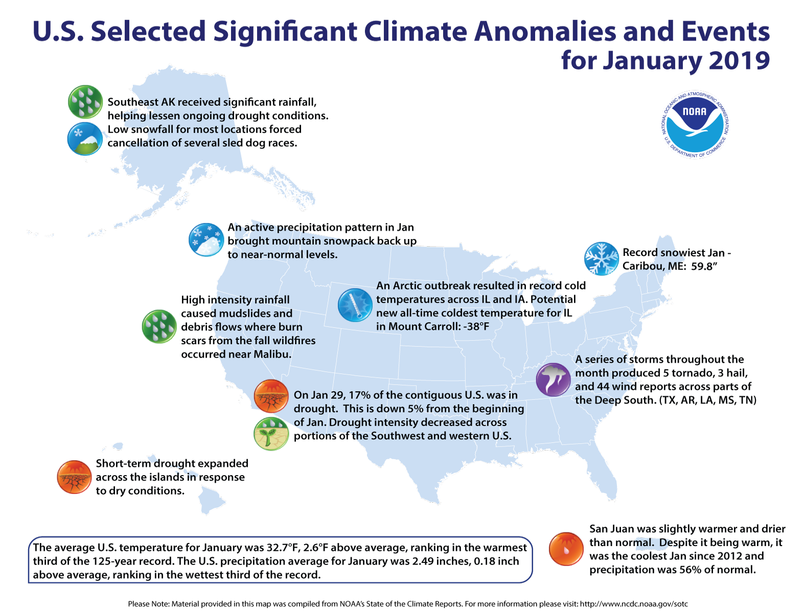
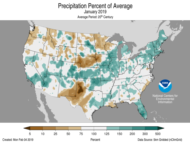
- January precipitation was above normal for much of the Midwest (131% of normal). Statewide numbers put precipitation even higher in Illinois (157%), Missouri (150%), Iowa (140%), and Indiana (134%). Four additional states had between 118 and 129% of normal. Only Minnesota was drier than normal with just 73% of normal in January. The driest areas of the region were in western Iowa where precipitation was less than 25% of normal and from central Minnesota into northwestern Wisconsin where a large area was less than 75% of normal and smaller areas had less than 50% of normal. The wettest area stretched from northern Missouri, through eastern Iowa and northwestern Illinois, into southern Wisconsin where precipitation totals were two to three times normal.
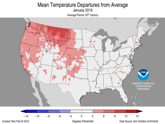
- January temperatures were below normal in the northern half of the Midwest and slightly above normal in the Missouri boot heel and across southern Kentucky. Temperatures were as much as 5°F (3°C) below normal in the northernmost reaches of the Midwest. The monthly average hides the extreme temperature swing from the very warm start to the month to the record-breaking Arctic freeze in the last few days of January. Temperatures were 10 to 12°F (6 to 7°C) above normal in the first week of January across the majority of the region. As the month progressed, temperatures dropped until the Arctic outbreak on January 30th through February 1st dropped temperatures to values not seen since the 1990s in many locations. Daily record low temperatures were recorded at more than 400 stations on January 30th and another 600 stations on the 31st. All-time station record for low maximum and low minimum was also set at dozens of stations in the Midwest. Several stations, including Beloit, Wisconsin, Moline, Illinois, and Rockwell City, Iowa, broke all-time record low minimum temperatures on January 30th only to break the day-old record again on the 31st. Notable all-time records were set at long-term stations (127 period of record) with -30°F (-34°C) at Cedar Rapids, Iowa, -32°F (-36°C) at Iowa City, Iowa (tied record), and -31°F (-35°C) at Rockford, Illinois. Although not yet certified, it appears that the Illinois statewide minimum temperature record was also broken with -38°F (-39°C) recorded at Mount Carroll, breaking the 1999 record of -36°F (-38°C) at Congerville.
- At least ten deaths in the Midwest were attributed to the weather in the last couple days of January. State of emergency was declared in Wisconsin, Illinois and Michigan. More than 1000 flights were cancelled at Chicago’s O’Hare Airport, Amtrak service to and from Chicago was cancelled on the 30th, classes were cancelled at schools and universities on the 30th and 31st, and even postal service was suspended on the 30th in parts of Minnesota, Iowa, Illinois, and Wisconsin to limit postal carrier’s exposure due to the dangerous cold and wind chills. In Michigan and Minnesota, there were calls to lower thermostats due to the enormous natural gas demand for heating. Wind chills dropped to the -50s and -60s in °F (-46 to -57 °C) in the upper Midwest.
- January brought heavy snows to the region. There were four major snowstorms affecting the Midwest in January. Monthly snowfall totals topped 12 inches (30 cm) from the Iowa-Missouri border to northern Michigan where totals topping 3 to 4 feet (91 to 122 cm) were common. Snowfall totals in northern Missouri, southeastern Iowa, west central Illinois and southern Illinois had more than three times their normal snowfall in January. A much larger area had more than twice normal and another area in southeastern Indiana, southwestern Ohio, and extreme northern Kentucky also had twice normal snowfall. On the other hand, large parts of Minnesota and Wisconsin had less than 75% of normal and a small pocket of northwestern Iowa and some locations along the southern edge of the region had less than 25% of normal.
- Drought was completely removed from the Midwest as of the January 1st release of the US Drought Monitor and the region remained drought-free throughout the month. The abundant rains that led to 2018 setting a new regionwide record (1895-2018 period) for precipitation and then a wet January for much of the region provided ample wetness for the region.
January Highlights
What happened to the avatars that used to be by our names?
Kids are enjoying the snow on the hill by me. Lots of sledding going on.
Lots of great snow melting days coming up!! Keep them coming!!
We are still ahead of last years seasonal to date snowfall totals!
Who cares?!?!! Last year at this time the PV was coming down, this year the beautiful warmer temps are coming in for weeks on end! Bye, Bye snow!! Who knew?!??!
I love these long winters that start in early November and potentially last till April!
Especially ones like our current one which have had snow on the ground for about 15% of the time, bare green grass the rest of the time!
I love 40’s in February!! That’s factually what’s on the way!! BRING IT!!!
Not much of a winter this season.. I love winter !!
Keep the snowstorms rocking and rolling!
https://weather.com/storms/winter/news/2020-01-19-late-january-storm-west-plains-midwest-east-snow-rain
Wishcast
What a simply spectacular day out on the trails! More of the same tomorrow! Keep it coming!
The snow just keeps coming! Incredible!
https://www.instantweathermaps.com/GFS-php/conussfc.php?run=2020012118&time=PER&var=ASNOWI&hour=384
Wishcast #2
Bring it!
http://wxcaster.com/gis-gfs-snow-overlays2.php?STATIONID=GRR
Wishcast #3
I’ll mark down your additional 6” of snow by Sunday prediction though! We’ll see how that prediction works out come Sunday!
Upper 30’s to low 40’s as far as the eye can see!!!
https://weather.com/weather/tenday/l/7f39432f98eef2d300f773cf914253d5f248e7131cb69cb63b087ebda662f574
The CPC is looking fantastic too!!
The mild winter continues .. Days just keep getting longer.. Rain on the way and no sign of the polar V.. I love it !
Here is the 7-day precipitation map. Sure looks dry for all of Lower Michigan!
 ?1579618114
This is totally wrong! Accumulating snow is on the way! Mark it down!
They have bumped up the precip already! Who knew?
The coldest it has gotten this winter so far is just +7. If we do not get below 6 the rest of the winter it will be one of the warmest minimum for any winter season in Grand Rapids recorded history. At this time it is 15 and cloudy here at my house.
Slim
I will be heading out to the trails later this morning and what a great winter day it is! Near perfect conditions continue! Incredible!
Get ready for more snow later this week into the weekend and beyond! I love this time of year!
No big accumulation expected.
Yup, denial still to some.. Lol !!
Good post MV. The past several months have been close to identical to last year, but looks like this is where we break off from the repeating weather pattern. A year ago we were sitting below and around zero for a week or two, not this year!
We will have to see how the next month plays out but this winter could be one of the top ten warmest in GR recorded history. Snow fall while below average should not be a top 5
Slim
15* degrees brrrrr out at thee YARDofBRICKS NE of GR a nother beautiful Winter day on tap in West Michigan …Have a super Tuesday …INDY
+1000!
Better enjoy it before all the snow gets hard and crusty and melted. Won’t last long!
Yes, it will snow this week despite the warm weather hype! Incredible!
https://weather.com/storms/winter/news/2020-01-19-late-january-storm-west-plains-midwest-east-snow-rain
Fortunately as we head into the February the temp trend will decrease and the snow chances will increase! Get ready for the wild part of winter! Winter rocks!
https://www.instantweathermaps.com/GFS-php/conussfc.php?run=2020012106&time=PER&var=ASNOWI&hour=384
LOL you said the same thing about December and January! I have the past posts to prove it.
I will have to dig out my video dvd from last January to prove that the PV actually happened! It makes me wonder… when was the last time that Grand Rapids saw a synoptic system drop more than 12 inches of snow?
February 1-2 2011. Storm total 17.2″
Slim
WOOD: “I don’t see any big storms or any super-cold air for the rest of this month into the first week of February.”