We have half of an inch of snow on the ground this morning with a temp of 31° at 4:30. Yesterday our high was 42° and the low was 30°. Our next chance of snow will come in the Sunday night/Monday timeframe.
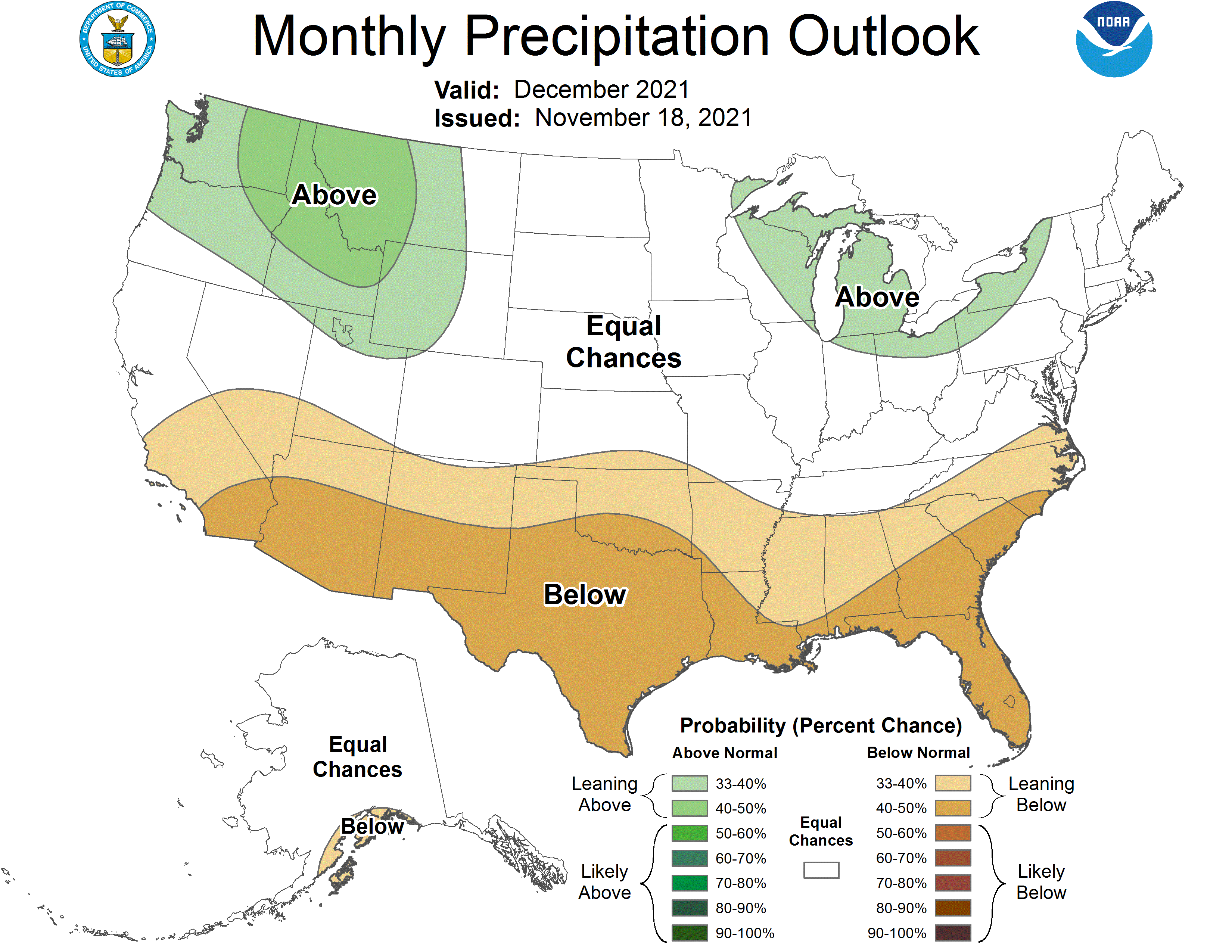
The CPC released its December outlook yesterday and they are guessing equal chances of above/normal/below normal temps and above-normal precip. my guess would be near normal temps for the month.
[columns] [span6]

[/span6][span6]
[/span6][/columns]
I am setting up a new computer system today and tomorrow, this site should remain the same, it is mainly a matter of massive file shuffling and upgrades.
Forecast Discussion
- Snow showers winding this morning

Troughing moves east today with surface high building in and
inversion heights falling below 5 kft with the DGZ losing
saturation as drying/subsidence continues. Fair weather expected
for Friday as profiles show warm advection but lack of moisture
until late Friday night when light showers are possible possibly
mixed with snow at the onset. Surface temperatures generally above
freezing Saturday morning so snow will be transient and not
expected to cause any travel problems.

- Storm late this weekend with rain followed by snow showers

Upper trough amplifying across southern Canada/Upper Midwest goes
negative tilt and surface low deepens across the central Great
Lakes late in the weekend with period of rain on Sunday followed
by another shot of lake effect snow Sunday night and Monday. This
cold push is more impressive with 850 mb temps around minus 12C
by late Monday along with saturation through the DGZ, so lake
effect snow could whiten the ground across much of the western
half of Lower Michigan with some 2 to 3 inch totals possible by
the time the thermal trough moves east on Tuesday.

The pattern repeats itself later in the week beginning Thursday
with another low deepening over the central Great Lakes.
I missed the lunar eclipse this morning, but the moon was huge and gorgeous over the western horizon this morning at 5:30 am. Just returned from ataking the dog for a walk. It is a beautiful, sunny day.
Here at my house I recorded a half inch of snow fall yesterday. The official amount at GRR was 1.7″ At this time the ground is white but the roads are not. For the month of November Grand Rapids now has a mean of 41.8 that is a departure of -0.4 and so far this month the official snow fall amount is now at 3.4″
Slim
Below normal temps in November and now the outlook for December is looking great for snow chances! Who would have thought? It is going to be a wild winter! Rock n roll will live forever!