This is the official first day of winter when the sun is at its lowest position in the southern sky in the northern hemisphere – we are tilted as far away from the Sun as possible, which means that the Sun’s path across the sky is as low in the sky as it can be. Think about the daily path of the Sun: It rises in the east and sets in the west, arcing across the sky overhead. During the summer, the Sun arcs high in the sky, but during the winter, it arcs lower, closer to the horizon.
Tomorrow the Sun’s path begins to advance northward again, eventually reaching its most northerly point on the day of the summer solstice. Another fun fact is that the sun is closer to the earth in the winter and further away in the summer. Our seasons are defined by the angle of the earth at the poles as we move around the sun.
We at are 22° at 5:30 this morning with clear skies. Yesterday’s high was 41° and the low 27°.
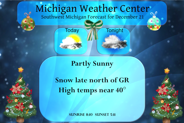
While we will have a green Christmas we will see a pattern change as we get to the new year as the colder air moves in from the west with the probability of a white New Years’ day increasing.
Forecast Discussion
- Chance for Snow Tonight and Thursday -

A couple of shortwaves will move into the region tonight and again
Thursday bringing chances for snow. Starting with the system
tonight, model trends continue to suggest generally 1-2 inches for
areas along the US-10 corridor with more of a dusting for areas as
far south as I-96. Some travel impacts will be possible, but most of
the impacts will be further north across the UP and parts of
northern lower where higher snow totals are expected.

Most of the precipitation with the Tuesday night clipper should
diminish overnight, but we may see a few shallow lake effect snow
bands persist into Wednesday morning before dry air moves in with
incoming surface ridging.

The next weaker chance for snow will arrive early Thursday as flow
turns southerly kicking off warm advection. Sounding profiles
support mostly snow, but it`s possible we could see some rain mix in
south of I-96. Overall not expecting much in regards to snowfall
amounts with around 1 inch north of I-96 and less than an inch to
the south.

- Unsettled Pattern Through the Holidays -

Conditions turn more breezy, mild, and wet for the holidays. The GFS
ensemble mean continues to show temperatures climbing into the upper
30s, with the ECMWF showing even warmer temps in the mid to upper
40s. That temperature discrepancy alone should hint enough that
there remains a bit of disagreement on how this system will play
out, but regardless, guidance is steadfast in painting this as a
slightly more potent shortwave than the early week shortwaves.
The GFS appears to be wetter and colder, while the ECMWF has
backed off slightly on precip amounts and is warmer.

While we are still lacking detailed consensus on how this Christmas
Eve/Christmas Day system will play out, there is consensus that our
prospects for a white Christmas look pretty meager as mild
temperatures will keep much of the snow at bay.
Here we are on the so call first day of winter and there a for the most part no ice on the great lakes in fact there looks to be temperature as least up to the mid 40?
Slim
Looks good and we are set up for some big lake effect events when the arctic air arrives! Bring on the polar vortex!!!
Looks identical to last year. We never really got any lake effect then either.
I love the fact winter has begun and we are headed into the coldest and snowiest time of year! Bring it on!
Well here we are at the winter solstice and while the is the so called official first day of winter. meteorological winter started on December 1st. The ground and roof tops are white this morning but with frost and not snow. The overnight low here with clear skies dropped down to 17 and at this time it is now up to 20. The official overnight low at GRR looks to have been 20. December now has a departure of +4.0 at Grand Rapids. +5.1 at Muskegon and whopping +6.6 at Lansing. All west Michigan’s major locations are below average in… Read more »
Great news! I love when the days start to get longer into spring and summer.
And by the end of December, about 30% of our total snow will have already fallen on average.
🙂
Boring weather. But, there was an awesome moon last night and this morning.
Great news>>>winter begins today and this is the time of year we see our coldest temperatures! Bring on winter and snow! Rock n roll will never die!