Yesterday’s high was 34° and the low was 28° with the clouds breaking momentarily for some peeks of the sun, not much but enough to know it still exists.
We have a rather boring weather outlook for this week leading up to Christmas. For travelers boring is good as they won’t have to worry about slippery roads this year. I am looking at one model giving us 50° and rain for Christmas Eve day. Most models are trending warmer than they were yesterday. We do have a chance of snow Tuesday night with an inch or so accumulation according to the forecast discussion – we will see if this actually plays out.
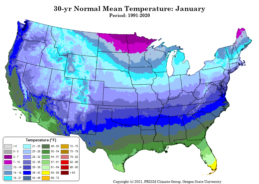
As we move on into the last week of December into January the guesses still favor near normal temps and above normal precipitation (snow). Below are the 30 year normals for January (look at the blue spot in Allegan County for precipitation, this is probably due to favorable locations for lake effect snow)
[columns] [span6]
[/span6][span6]

[/span6][/columns]
Forecast Discussion
-- Breezy Monday --

Southwest gusts over 30 mph are being measured between Muskegon
and Ludington early this morning, and gusts 25 to 30 mph will
become common over the rest of the area during the day as mixing
depth increases. High temperatures will be a little warmer than
normal today, but after the cold front goes through this evening,
lows tonight look a little cooler than normal.

-- Chance of Snow Tuesday Night and Thursday --

Shortwaves (Alberta clippers) propagating through the upper level
flow will bring a couple chances for snow during the middle of
the week. Tuesday night`s setup looks more robust than Thursday. A
developing surface low moves right over Lower Michigan Tuesday
evening bringing a several hour burst of precipitation. The 00Z
and 06Z HRRR have come in with 1 to 2 inch snow in Central
Michigan down to I-96 while the coarser global models remain drier
along I-96. Blustery winds and temperatures falling well into the
20s can also be expected on the backside of the low during the
night. The temperature profile supports some lake effect Tuesday
night but the question will be how limited it is given the ridging
and upstream dry air. Bottom line, the snow, wind, and falling
temperatures may create some travel challenges near and north of
I-96 Tuesday evening into Wednesday morning.

Thursday`s wave at 500 mb is fairly weak but is in the left exit
region of the upper level jet. Light precipitation will likely be
produced in the warm-advecting mid levels but will have to fall
through drier air near the surface. Temperatures mostly support
snow through may warm up enough during the afternoon so that some
rain mixes in.

-- Unsettled Weather For The Holidays --

A majority of GFS and ECMWF ensemble members continue to show a
mild Christmas Eve with temperatures climbing at least into the
40s. The ECMWF ensembles lean warmer than the GFS ensembles do.
This is as a potent shortwave moving across the country trends
toward negative tilt and develops a broad low pressure system over
the Great Lakes. The median solution is for a quarter inch of
rain Friday evening / Christmas Eve but there remains substantial
variability in the ensembles. Temperatures will likely turn colder
after a period of breezy winds behind the cold front either late
Christmas Eve or Christmas morning, but the air on the backside of
the low does not look to be terribly cold and if the shortwave
pattern remains progressive, ridging will also work to keep lake
effect limited.
Breaking news>>>>most people realize that winter starts at the winter solstice, so get ready winter is almost here! Incredible!
Around 59 degrees with rain for Christmas and one of the warmest Decembers on record? That is a far cry from the 314 times we were told how cold and snowy it was going to be this month. Even Bills prediction a month or 2 ago seems to be quite a ways off. Who wouldn’t love a mild December with plenty of sunshine?
Great news winter begins soon and we have about 89 full days of winter to rock
on! I love it!
When? You’ve been saying that for months now and we are warm with well below average snow.
Boring? I would call this weather absolutely horrendous!
Wow, WOOD has 43 degrees and rain for Christmas Eve, and 48 degrees and rain for Christmas Day. Looks like yet another warm week and another short winter!
Man, I just love short winters!! Days start getting longer tomorrow, and every day we get closer and closer to spring!!
https://days.to/until/spring
Spring is coming quickly now!
Thanks for reminding me that we are about to enter the coldest and snowiest stretch of winter and it could last for about 10 to 12 weeks! Bring it!
At this time there is no snow on the ground here at my house. The official overnight low at GRR looks to have been 29. Here at my house the overnight low has been 30 at this time it is 31 here with some fast moving clouds moving across the moon. The current mean temperature for December at Grand Rapids is 35.8° if it were to hold that would be good for the 3rd warmest December of record. The current forecast high of 49 for Christmas Eve would be the 11th warmest for any December 24th at GR and the… Read more »
There is snow on the ground. We have most of the presents wrapped. We hit the grocery store yesterday and got everything we’ll need for the weekend. I am SO ready for Christmas.