With all the hype of balloons and other UFOs cruising in our skies, I thought it would be a good time for a post on weather balloons which are launched into the skies twice a day.
There are currently more than 800 radiosonde sites worldwide, with the United States/National Weather Service running or supporting 92 sites in North America and the Pacific region, and another 10 sites in the Caribbean.
The program allows for a time-synched upper atmospheric “snapshot” across the entire globe as soundings are typically launched at a specified time. These worldwide soundings are then ingested into the various global and synoptic scale forecast models as a main source of information for the various forecast models to initialize off of and produce forecasts for meteorologists and various other users. These soundings are also used extensively as a real-time data source as well, as the information can be plotted on various thermodynamic diagrams such as Skew-T log-P Diagrams and Stuve Diagrams providing valuable information to meteorologists. Atmospheric soundings are also used extensively for air pollution models and climate research. For more information about the history of upper-air observations please click here: History of Upper-Air Observations.
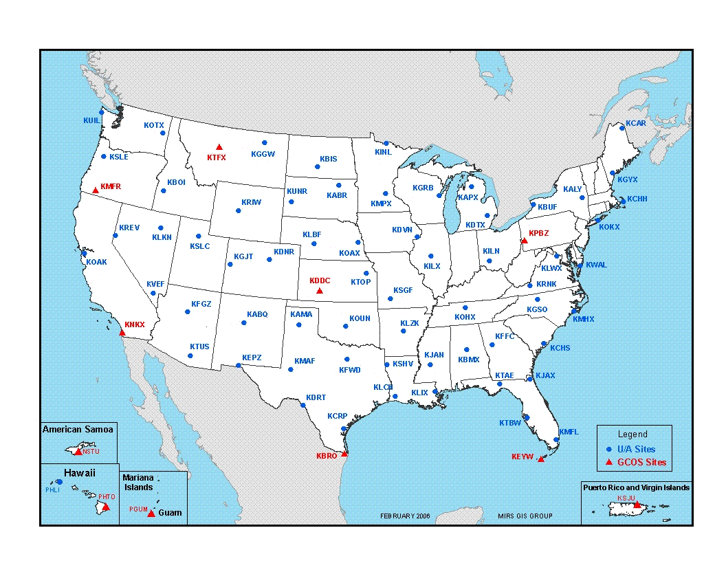
Map of CONUS Upper-Air Observing Stations
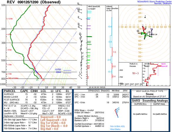
SkewT log-P Diagram with additional sounding data and calculations
Courtesy: NOAA/NWS – Storm Prediction Center
Across the entire planet twice a day at midnight and noon Zulu time ( Greenwich, England), weather balloons with radiosondes attached under them are launched to sample the global atmosphere. For NWS WFO Reno our weather balloons and radiosondes are launched at 4 am and 4 pm Pacific daylight savings time and at 3 am and 3 pm Pacific standard time. These flights are launched in all weather conditions ranging from blizzard conditions to high wind to temperatures over 100 degrees 365 days a year including weekends and holidays. The only real exception or delay of a flight would be when convective activity, like a thunderstorm, is present over or near the weather station. It is also important to note that “Special” soundings may be flown for various reasons which can include research, when rapidly changing conditions are present in the atmosphere, or when severe weather is expected in a region.
Each flight utilizes a weather balloon or sounding balloon which is a large specially made latex balloon which is designed to carry the instrument aloft in upwards of 90,000-100,000 feet! On the surface, prior to launch the balloon is roughly 6 feet wide, and when the balloon reaches its termination level, the balloon can be larger than a 2-car garage. This is because as the balloon ascends through the atmosphere, pressure decreases, thus, allowing the balloon to grow larger and larger the higher the balloon ascends.
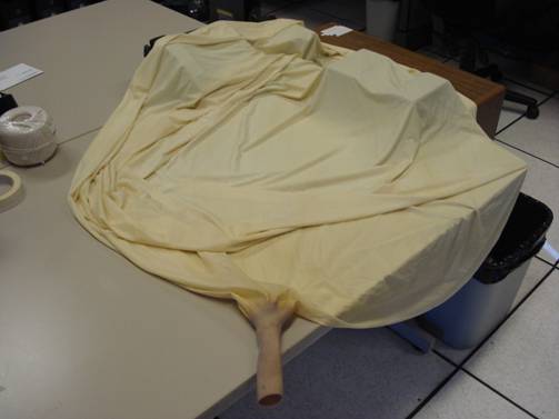
Standard National Weather Service Weather Balloon Pre-inflation
Next, we have the instrument (radiosonde) which measures the pressure, temperature, and humidity. The wind speed and wind direction are also measured by either a radio direction-finding antenna or using the satellite-based Global Positioning System (GPS). WFO Reno just recently went through the Radiosonde Replacement System upgrade and uses GPS-based radiosondes.
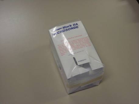
Mark IIA Radiosonde with GPS Receiver
The sounding train also includes a biodegradable parachute that deploys as the radiosonde returns to Earth after bursting at termination. Without it, the returning radiosonde could pose a danger to people or property since it weighs roughly one pound. The radiosonde will typically land well over 100 miles from the launching station.
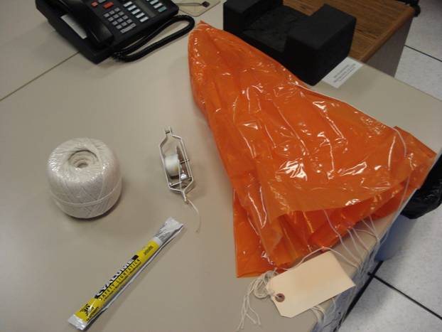
Upper-Air Supplies – Twine, Chemlight, Train Regulator, and a Parachute
On the 12z (3 am or 4 am depending on the season) a non-hazardous chem light is attached to the sounding train to help aid in visibility. This is particularly helpful for aircraft.
During launches where high winds are present, a special radiosonde train regulator is used to help aid the observer with the launch. As the weather balloon ascends through the atmosphere, the radiosonde train regulator unwinds and slowly increases the train length to the desired length for the sounding, which is typically 80 – 120 feet.
The upper-air program remains vital for providing data to a number of entities and agencies. It serves as perhaps an antiquated method for gathering data in view of today’s modern era, but still proves to be quite effective in its mission of sampling the upper atmosphere. Of the approximately 75,000 radiosondes that are released yearly, only about 20% are found and returned for reconditioning. If you happen to be lucky enough to find a radiosonde, follow the directions on the instrument, and use the provided, pre-paid envelope to send the radiosonde back to the National Reconditioning Center.
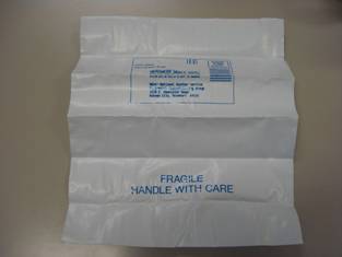
After the last messages are transmitted, all of the computer systems are shut down and will remain off until the entire process starts again 12 hours later. One last interesting note…despite all of the differences between people and governments throughout the world, every observer, no matter which continent or country they are from…we all launch our weather balloons at the same time! Thank you for taking the time to view WFO Reno’s Upper-Air virtual tour. For more information, please visit the National Upper-Air Program page.
Today ends our string of sunny days, A few sprinkles or showers are possible this afternoon, then showers will become likely this evening. Gusty winds (40–50 mph) are expected in many areas on Wednesday. Another system will bring additional precipitation on Thursday into Friday morning.

Today we will see possible record max temperatures. Here is a list of the forecast Max Temperatures across the area. Also are the normal and the Record Max temperatures along with the year they occurred.
Grand Rapids Forecast
214 grrLansing Forecast
214 lanKalamazoo Forecast
214 kzoForecast Discussion
-- Warm Today --

Advection of 925 mb air around 8 to 9 deg C and mixing to that level
today should bring our high temperatures to the 50s. These 925 mb
temperatures would translate to being near the warmest recorded for
the date in the sounding climatology for DTX, and not surprisingly
would put our surface temperatures near record warm for Feb 14. See
Climate section below for exact numbers in various cities. The
records for Feb 14 are at the lower end of the range compared to
other dates during this week so are a little easier to achieve.
Still, it`s another dose of warmth in what is so far a top 10
warmest winter since December 1 (going back about 125 years).

-- Rain and Wind Tonight and Wednesday --

The low pressure system tracking from Iowa to Upper Michigan tonight
will have a robust 50 to 70 knot low-level jet core from Tennessee
to Michigan. Winds greater than 45 mph will tend to be 1000 feet off
the ground for much of the night, though sporadically could mix
could down with periodic showers falling through initially dry air.
Lapse rates in the lower levels will be somewhat stable but not
overwhelmingly so tonight. That changes with slightly colder air
arriving around/after daybreak Wednesday which should promote mixing
of a lingering core of southwesterly 45+ mph winds to the ground,
the wind speeds being enhanced by the isallobaric component as our
surface pressure locally rises here by 15 mb in 12 hours. Will start
a wind advisory for tonight through Wed afternoon but feel more
confident for more widespread gusty winds beginning around/after
daybreak Wed.

-- Wintry Thursday For Some --

Global models and their ensembles continue to indicate the most
likely track of the next surface low to be closer to the southern
border of Michigan on Thursday. All things considered, what could be
a 3-to-6 or 4-to-8 inch snowfall in 12 hours from the deformation
zone would most likely be north of a Muskegon to Mount Pleasant
line, and farther south there will be lesser amounts with some rain
to sleet to snow mixing challenges. The latest ECMWF ensemble member
QPF spread for Big Rapids and Ludington remains uncomfortably high
for now, so snow amounts are not quite settled. High temperatures
for Thursday continue to trend downward as a northern track for the
low looks less likely.

It was great weather for walking the dog today. She was loving it. Nose to the ground and all the great smells. She is catching on to walking on her leash.
I won’t post 100 links to the CPC like Andy does, however the latest CPC is showing below normal temps and above average snow fall next week! Who would have thought? Incredible!
Who cares??? There hasn’t been snow on the ground and the temps have been well above average for 75 percent of this winter! IDGAF what you do.
GR is now close to being a top 20% easiest winters ever recorded. Meteorological spring is also only 2 weeks away and we are gaining lots of daylight now!
I think it is about time to review the facts! 1. GR is well above normal for seasonal snowfall with many more weeks of snow chances! 2. We are in a wind advisory for Wednesday! 3. We will be in a Winter Weather Advisory for Thursday and I expect GR to get 3 to 6 inches! 4. I will be skiing and snowshoeing starting on Friday! 5. Winter rocks and is the best! 6. GR is still on track for my prediction of around 90 inches of snow this season! 7. Who would’ve want snow this time of year! 8.… Read more »
I am sorry for venting my frustrations and getting everyone all riled up. What do you say we end this conversation right here and now?
Back to the weather. Another amazing day today. Looks like we’ll be right on the edge of accumulating snow Thursday. Maybe some mix, maybe all snow, maybe all rain?
BTW, this is a great post on weather balloons.
NP Mark and you have every right to vent your frustration! Keep the faith!
It’s very frustrating. The amount of time I spent in the union, from late-night dinner, tutoring, working as a TA, going to Sparty’s, and bowling, and now thinking that this happened there, is very frustrating. I can’t imagine what current students/parents are dealing with
The good thing is that the past couple generations really know nothing about the tragedy of war like WWI, WWII, and Vietnam. And they have never been worried that Russia will drop a nuclear bomb on them. While these isolated incidents are awful, we can’t lose track of the big picture. Things are definitely improving both in the US and around the world in terms of war time deaths, disease, poverty, racism, and education.
Everyone is entitled to their own opinion but I do not agree with you.
Record high temps and lots of golfers again today!
Good, winter is garbage and I’m glad the tiny amount of snow we’re going to get Thursday will be melted by Sunday again! Drive 300 miles north if you like that slop!!!
Looks like Holland has already shattered their record high, up to 55 degrees now, and GR has at least tied the all time record of 53. Almost unbelievable weather we are having. Grills back out and doing burgers this afternoon.
Get ready, we have tons of cold and snow in our future! Winter weather is far from over! Incredible!
Thanks for the balloon info! I always knew about them but guess I never realized just how many are launched every day. It would be really cool to find one someday, and yes I would definitely mail it back!
GR could be headed for a top 10 seasonal snowfall? Wow to the wow!
I guess you love watching snow melt LOL It’s one of the least amount of 1″ snow days ever recorded.
Top 10 warmest winter ever and only getting warmer!
Get ready – wind advisory for Wednesday and we will be in a WWA for Thursday! Accumulating snow is in our future and then next week a turn to a colder and snowier pattern! We have a lot of winter weather left this season so get ready to ROCK!
Condolences and prayers to those families of students killed and injured in Lansing last night…
Agreed but with the amount of guns and assault weapons out on the streets it is no surprise!
The perpetrator in this shooting had already been busted for a weapons charge in 2019, and was given a very light sentence and was released after only a year in jail in 2021. So the system already failed because this guy illegally had a gun, so background check would not have worked. He was illegally concealing the illegal handgun he had, because he was a convicted felon. He was illegally carrying a gun in a gun free zone. He committed these murders with a hand gun, not an assault rifle. So he broke probably 30 laws or so in committing… Read more »
I agree that stricter penalties may be helpful. Important to note – the majority of mass shootings are committed by lawfully purchased firearms.
Again, I don’t know what the answer is. However, I do know that this is a uniquely American issue. The US averages more than one mass shooting per day. No other country even comes close. The #1 cause of death for Americans 21 and under is gun violence. How is that acceptable??
Rock on Mark! USA owns46% of the Worlds guns! The more guns that are in the hands of crazy, careless, reckless and violent people the more gun deaths there will be! Just the facts! Ridiculous!
Give me a break and forget about all your excuses!
Not excuses, just facts about this case. When guns are taken away from law abiding citizens, the only people that have guns are the crazy, violent, criminal people!
Shallow and ignorant viewpoints!
You bring nothing to the table other than insults and hyperbole.
Sorry, I would rather protect my family from an armed intruder with a legally purchased firearm. I’m not going to rely on 911, that could take the cops 10 minutes or so to show up. Ten minutes is a long time when dealing with a psycho breaking into your house.
Take your assault weapons and shove them!
https://www.everytown.org/solutions/assault-weapons/
I don’t have any assault weapons! I have a 12 gauge pump, 20 gauge pump and a 22 rifle. All legally purchased, all required background checks, all purchased from local sporting goods stores, all purchased for home protection and target shooting at a state sanctioned gun club.
WTF Michael V & Slim??? You guys just let this guy talk garbage to all the posters on here. No wonder postings from people on this blog have plummeted in the past few years!
You are the biggest instigator on the blog!
Please, I took a year off from this blog and your instigation never stopped. Posting BS snow maps that show Grand Rapids getting 24 inches of snow every other week. Posting liberal rhetoric regularly, and taunting other posters often.
Wake up and swell the coffee!
https://time.com/6183881/gun-ownership-risks-at-home/
Garbage from the liberal rags that you pump up! Of course someone like you shouldn’t own a gun because you wouldn’t know what direction to point the barrel! But for gun owners like myself who have taken gun safety course and had the proper training, having a gun for home defense or for hobby shooting should be encouraged!
I bit my tongue last week because this is a weather site, and I appreciate that. Another day, another nightmare. Our son is a sophomore at Okemos High School – you know, the one that local, state, and federal law enforcement responded to due to the hoax last week. Ask anyone in our community, that did not feel like a hoax. That happened just a couple of days after someone blew his brains out on the playground of a nearby elementary school, only to be found by young children while outside on recess. Hoax or not, my wife and I… Read more »
Criminal background checks! Red flag laws! Assault weapons ban! Just few common sense things that could be done! There are more ideas, but these are the bare minimum that needs to get done!
We already have background check laws in Michigan! But liberal prosecutors keep letting career criminals back out on the street and they keep committing crimes to add to their mile long rap sheets! Punish the career criminals not law abiding citizens!!
Even your Lord & Savior Whitmer said she would not take away hunting firearms, which is all I own.
So sorry your family has had to go through that. I taught in the elementary…it was scary as a sub to do a drill of this nature with kindergartners. As a lower el teacher it is weird to go in and plan your classroom for what may happen…what can kids hide behind, what to put in front of a door.
I checked with friend whose kiddo goes to MSU. He is ok, but shaken.
I will be praying and thinking of all those injured and their families and those who lost kids last night and how everyone moves forward.
My wife is an elementary teacher. Every lock down drill the little kids are crying in a corner not knowing if it is real. I can only imagine the Terrible physiological harm that is being done to these young children, all because politicians are afraid to actively seek solutions. Heck gun violence research was not funded for 20 years due to congress “banning” it. I guess it is easier to pretend a problem doesn’t exist than do something about it.
https://www.nature.com/articles/d41586-019-03882-w
Your wife has my unwavering respect. I am so proud of the faculty and staff at OHS. They remembered their training and kept our kids safe. Ingham County Sheriff praised them for their courage and calm, believing that there was an active shooter on site and two students had been shot.
Thanks SS. It’s been a tough two weeks around here. A good number of kids are too scared to return to school, which is just heartbreaking.
Tragic event once again in our great state. I cannot fathom how the affected families feel right now. So sad.
Bring back Insane Asylums. Some of these crazy individuals need to be locked up forever. Lock up career criminals forever too.