We have had 7 inches of snow so far from lake effect which brings us to 10 inches for the month and 23 inches for the season. Some areas in Kent and Ottawa counties have seen well over a foot of the white stuff. Grand Rapids broke a daily snowfall record for Jan. 5, with 8 inches of fresh snow. The old record was 6.4 inches, set in 1954. Muskegon also broke a daily snowfall record with 5.3 inches Wednesday. We had seen very little lake effect over the past fives years this will possibly make up for lost snowfall this year. What we have on the ground should stick around for awhile as the CPC guess have us at near normal temps and precipitation over the next couple weeks.
We currently have light snow falling with a temp of 14°. Yesterdays high was 20° the low was 4°. Temps are generally in the low teens to single digits across southern Michigan and single digits into negitive territory in northern Michigan this morning.
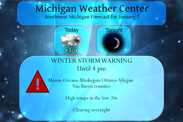
...WINTER STORM WARNING NOW IN EFFECT UNTIL 4 PM EST THIS
AFTERNOON...

* WHAT...Heavy snow. Additional snow accumulations of 1 to 7
  inches.

* WHERE...Ottawa, Allegan and Van Buren counties.

* WHEN...Until 4 PM EST this afternoon.

* IMPACTS...Plan on difficult driving conditions at times. The
  hazardous conditions could impact the morning commute.

* ADDITIONAL DETAILS...US 31, I-196 from Zeeland to South Haven,
  and I-94 west of the Kalamazoo and Van Buren County line look to
  be most impacted with heavier snow showers producing
  accumulations of a half inch to one inch per hour. Some primary
  and secondary roads across western Van Buren County may be in
  very poor condition with significant amounts of snow covering
  the roadways. Eastern portions of these counties will likely
  have much less in the way of travel impacts.
Forecast Discussion
- Lakeshore Snow Showers into this Afternoon

The heaviest snow shower activity still looks to be confined to the
western halves of our lakeshore counties through the morning and
into early afternoon before diminishing. Significant snow
accumulations have likely been occurring underneath the dominant
band that has been passing over Big and Little Sable Points and
coming onshore across extreme western Allegan County and into
western Van Buren. Treacherous travel conditions have been observed
west of Paw Paw on I-94 which is where models have consistently
shown a max in omegas within the DGZ. For Ottawa and Muskegon
Counties, little occurred overnight as the band has remained
primarily offshore, but we are still expecting a slight jog to the
east through the early to mid morning hours (as is already occurring
in fact), bringing the western portions of those counties in play
for 0.5"-1.0"+/hr snowfall rates for a time with some locally
significant travel impacts. Other locations across eastern portions
of our lakeshore counties will see considerably less snow with only
minor inconveniences to travel.

There is a question with regard to how quickly the band moves inland
and dissipates. The Nam3km does this several hours quicker than the
HRRR/RAP13, which prefers little movement in the current band
placement, perhaps an initial jog to the east and then a migration
back toward the coast before weakening. Lift within the DGZ, 1000mb-
700mb RH, and 925mb-850mb omegas suggest we need to stretch out the
Warning a bit further in time than previously thought as these model
fields are not declining until mid afternoon or so. In addition, it
is looking less likely that the band will cause Warning level
impacts to Kalamazoo County so we are downgrading to an Advisory, as
there should still be impacts to travel primarily for the western
half of the county especially between 09z-18z.

- Very Light Wintry Mix Possible Saturday Night

Model guidance indicates less than a tenth of an inch of mixed
precipitation is possible Saturday night as a robust 50kt LLJ
advects warmer air and some Gulf moisture up into Lower Michigan.
This looks to occur at night with temperatures in the upper 20s to
low 30s. Although this looks like a minor event, there could be some
slippery roads developing if the precip stays liquid until contact
with colder road surfaces, turning it to ice.

- Lake Effect Snow Showers for Sunday Night through Monday

Another blast of Arctic air arrives Sunday into Monday with a WNW to
NW lake effect setup taking place. With the DGZ dropping toward the
ground the flake size will not be optimal, thus accumulation rates
will likely not be very impressive, but often in these setups the
visibility reductions can actually be worse than events that produce
larger dendrites. In addition, 850mb winds look to be 30-35 kts
which should get some snow shower activity inland a bit. Surface
winds look to be 15-25 kts so there could be some travel impacts
from this event even though it may not be a significant snow
producer.

- Milder Mid Week to Late Week Period

After highs in the teens early this upcoming week, we look to
quickly rebound into the 30s as rising mid level heights and low
level warm advection takes shape over the Great Lakes. Toward the
end of next week there is some support by ECE ensemble members of
additional precipitation that could impact our region, potentially
snow. Upper level pattern evolution a week out, however, is highly
variable and subject to change until details become clearer.
What a simply fantastic winter storm! Hopefully we will see many, many more this winter! I plan on skiing tomorrow and snowshoeing on Sunday! Conditions should be incredible! Winter is the best and rock roll will live forever! Get outside and enjoy!!!
It has been snowing continuously since before 5 am here in Otsego – we have 11 inches of snow on the ground…
The lakes are freezing over fast ice fishing at its best …InDY …
Did you see Zeeland picked up 18 inches of snow from the storm? I love it!
With some clearing the overnight low here dropped down to 0° the official overnight low at GRR looks to have been +1. Of course that it by far the coldest it has been this winter season. at this time it up to +5 here with clear skies to the east and clouds to the west, overhead there are clouds but to the east and NE it is clear. Officially GRR reported 5.3″ of new snow fall yesterday. Here at my house I recorded 6.5″ yesterday at GRR they reported 11″ of snow on the ground here at my house I… Read more »