
Yesterday was another cloudy day with a bit of drizzle, the high was 38.5° and the low was 32°.
If we can count on anything it will be the clouds during our short winter days in SW Michigan. Any sunshine which may break through the clouds is a moment of rejoicing and we can break into a happy dance, just as we do when the Lions win another football game.
In the forecast discussions, you have read about vertically stacked cyclones. This is a low-pressure system, usually a closed low or cutoff low, which is not tilted with height, i.e., located similarly at all levels of the atmosphere. Such systems typically are weakening slow-moving, and are less likely to produce severe weather than tilted systems. However, cold pools aloft associated with vertically-stacked systems may enhance instability enough to produce severe weather.
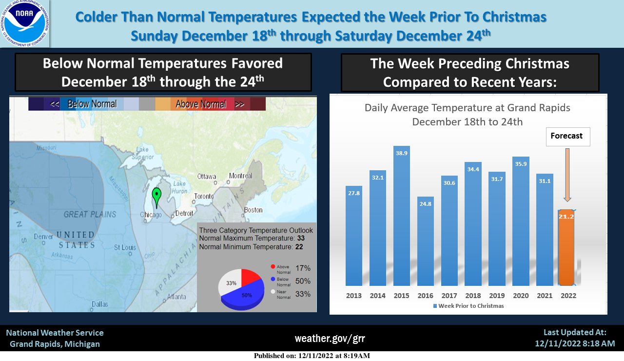
After being mostly warmer than normal through the middle of December, a much colder period continues to look more and more likely for the week prior to Christmas. If the current forecast were actually correct, it would be the coldest since the 14.4 degrees in 2000. We are expecting lake effect snow nearly every day from Saturday the 17th, through Christmas day. It is looking more likely we will have a White Christmas this year.
7-Day Forecast 43.03°N 85.66°W12 12
Forecast Discussion
-- Dry into Tue --

GOES WV imagery and recent RAP mesoanalysis show a mid/upper
ridge axis extending from the central U.S. to near Hudson Bay.
This ridge will amplify today in response to a digging upstream
trough over the western U.S. and sustained low-level warm
advection across the plains. Low-level moisture will maintain
extensive stratocumulus across the area into much of Tue, but
midlevel subsidence/drying downstream of this ridge axis will
provide for dry conditions.

-- Precip likely Wed and Thu; mixed p-types expected --

In response to the digging western U.S. trough, a lee cyclone will
consolidate today over the CO plains, then reach the vicinity of
eastern NE by 12z Wed as an occluded and vertically stacked system.
Precip within the associated warm conveyor belt will advance well
east of the stacked cyclone, reaching Lower MI as soon as late Tue
night.

Precip probs/amounts through Wed evening across the eastern/northern
forecast have trended slightly lower in EPS and GEFS guidance.
Indeed, forecast profiles on Wed depict appreciable low-level dry
air that may result in substantial evaporation/sublimation of
falling precip along this leading precip edge. However, renewed
cyclogenesis over the mid MS valley on Wed night, as indicated by
a majority of EPS and GEFS members, should provide an impetus for
widespread precip in Lower MI on Wed night into Thu. As this
secondary low progresses northward, an advancing dry slot will
likely bring an end to widespread precip in the forecast area
during the day Thu.

Regarding p-type, forecast thermal profiles and p-type diagnostics
for the daytime Wed suggest primarily rain for areas southwest of a
Ludington-Lansing line. Rain may be preceded by a period of snow
or sleet, but any rain-snow line should tend to advance
northeastward through the day. The main risk for freezing rain
appears to be Wed evening into Thu morning, and primarily north of
a Pentwater-Alma line. Within this area, profiles exhibit an
elevated warm layer (4-5C near 850 mb), and EPS/GEFS probs of
subfreezing surface temps are highest from Wed night into Thu
morning. However, surface temps will likely climb above freezing
throughout the forecast area on Thu, effectively limiting the
duration of any ice accumulation and related impacts.

-- Fri and beyond --

Ensemble means suggest that a vertically stacked cyclone will be
positioned over the northern Great Lakes by Fri night.  This should
result in westerly low-level flow over Lake Michigan on Fri, with
EPS-mean 850-mb temps falling to -10C by 12z Sat. Lake-effect
snow showers are likely from Fri into at least Sat night. Highs on
Sun will likely remain below freezing for most locations, with
broad ensemble support for below-normal temps through next week.
The latest CPC shows cold and snow as far as the eye can see!!!!!!!
Yea I agree above average snowfall for December is not out of the question..INDY
I love how this week looks anything but quieter! Big transition this week with plenty of clouds and a major transition to colder and snowy weather! I love it!
I love how we are well above normal for seasonal snowfall and all signs point towards a cold and snow end of December and beyond! Great start to the winter season! Rock n roll will live forever!
I expect the snows will be skipping a few places and blowing our way more the marrero!! Definitely going to be a shocker for some stay tuned…INDY 🙄
Who would have thought? Winter will be rocking!
I love these multi-week warm and quiet periods. Makes the winter go by quickly. Looks like another quieter week this week.
The week of Christmas is the best week of the year for snow (except for traveling… that could be a big problem potentially). I’m definitely ready for more snow!
I’m hoping some of that expected snow finds its way this far inland.
#hopingforawhitechristmas
#golions
#wonfiveofthelastsix
Yesterday was a rather gloomy day with an official H/L of 38/32 there was 0.01” of rain fall, no snow fall and no sunshine. At 70AM there was a trace of snow on the ground. The temperatures held steady overnight with the low here in MBY of 34 and that is the current temperature. For today the average H/L is 37/26 the record high of 60 was shared by 3 years 1899,1949 and 1991. The record low of -5 was set in 1958. The record snow fall amount of 6.0” was set in 1903 and 1972. Today will be another… Read more »