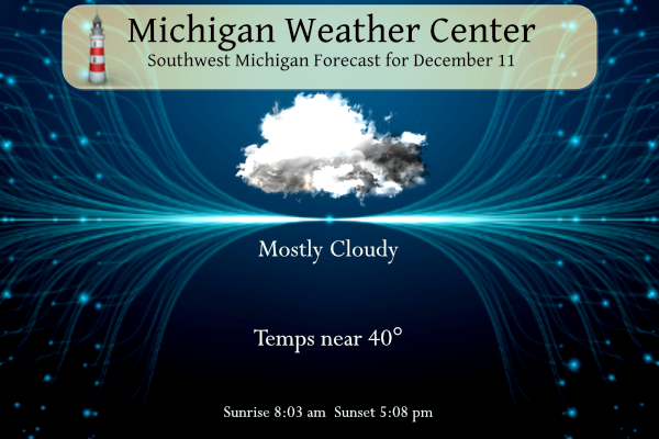
This week’s weather appears to be a fairly gloomy one with mainly cloudy skies every day. Chances of precipitation increase Tuesday night right on through the rest of the week.
Yesterday’s high was 34° and the low was 31°.
7-Day Forecast 42.99°N 85.67°W 12 11
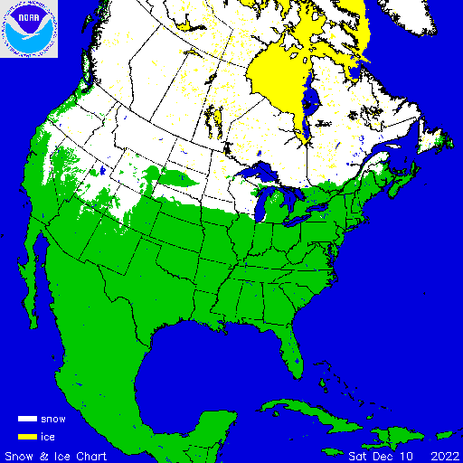
This is the current snow cover map tor the U.S.
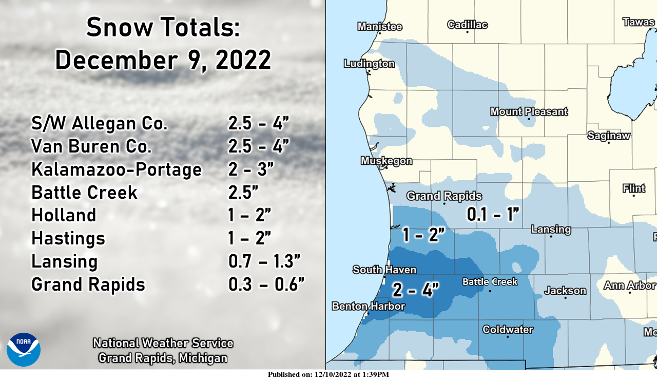
The snowfall from our last system
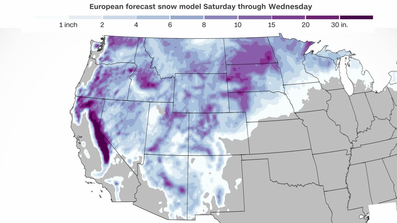
Euro Snow forecast
Forecast Discussion
.UPDATE...
Issued at 533 AM EST Sun Dec 11 2022

I have updated our short term forecast increase the fog and
increase the risk of seeing precipitation early to mid morning.
Both web cams, traffic cams, and surface observations show area
of dense fog near and west of US-131. Both GRR and AZO have 1/4SM
in fog as I am writing this. Most other reporting sites are below
2SM in mist/fog over all or our CWA. Air temperatures are mostly
33 to 35 degrees near and south of I-96 but 28 to 32 degrees just
north of I-96. I just walked outside our office and we are having
drizzle (not picked up by ASOS)but this is being shown by our 88d
radar. Also the radar show some showers moving on shore currently.
This is associated with a weak cold front and associated
shortwave. I am thinking the passage of this weak cold front will
lift the fog by mid morning. The are rain showers south of Grand
Rapids and snow showers north of Grand Rapids (based on radar
indications of PTYP and surface observations). There likely is
some very light drizzle drizzle north of Grand Rapids. The Midrive
map does not show much in the way of travel issues currently, were
air temperatures are below freezing over.

The bottom line is expect periods of drizzle, fog, locally dense
and few brief showers or rain (near and South of GRR) or snow
(north of GRR). The showers, fog and drizzle should all be gone
by mid morning.


.DISCUSSION...(Today through next Saturday)
Issued at 320 AM EST Sun Dec 11 2022

-- Lingering precip into this afternoon, then dry into Tue --

A midlevel low is progressing through the region early this morning,
with the 500-mb circulation centered over northern Lower MI as of 3
AM, per RAP mesoanalysis. South of this feature, midlevel drying is
noted in WV imagery over far southern Lower MI. Coinciding with this
midlevel drying--mainly south of I-96--an underlying cloudy layer
exhibits cloud-top temps warmer than -10C. This relatively
shallow cloud layer will again tend to limit precip production to
patchy DZ, with FZDZ possible through late morning where surface
temps are subfreezing. In areas north of I-96, pronounced midlevel
drying has yet to occur, with forecast profiles showing modest
moisture in the DGZ. Patchy light snow is possible in these areas
through late morning. The bottom line is that slick spots are once
again possible this morning owing to freezing drizzle and light
snow, with bridges/overpasses most prone to icing.

A weak surface low will develop in southern Ontario this morning in
response to the approaching midlevel low/trough. Light
northwesterly low-level flow will develop over the region, with
850-mb temps falling to near -6C. This may support a few lake-
enhanced sprinkles, but most locations will avoid measurable
precip today.

Upstream, a mid/upper ridge extending from the central U.S. into
central Canada will amplify tonight and into Mon, aided by sustained
low-level warm advection. Subsidence downstream of this ridge axis
will maintain dry conditions in the forecast area from tonight into
Tue.

-- Precip likely Wed and Wed night; a wintry mix possible --

Models continue to indicate that the vigorous upper low/trough
currently off the OR coast will continue southeastward, reaching the
Great Basin by Mon evening. At the surface, a lee cyclone will
consolidate over the CO high plains on Mon, then subsequently
occlude and become vertically stacked on Tue, only reaching the
vicinity of northeast NE by 12z Wed. The associated warm conveyor
belt will advance eastward toward the Great Lakes on Wed,
accompanied by deepening moisture and forcing for ascent. Model
thermal profiles continue to suggest that a range of wintry
p-types are possible on Wed into Wed night, depending on (1) the
depth and northward advance of a possible elevated warm layer, and
(2) the extent of possible subfreezing near-surface temps.

-- Precip again likely on Thu --

An increasing number of GEFS members now develop a secondary surface
low on Wed night over the OH valley, southeast of the
occluded/stacked low over the plains. This trend in the GEFS now
more closely resembles the EPS membership, with numerous solutions
clustered around a surface-low position near central IN by 12z Thu.
Given this emerging indication of subsequent cyclogenesis, renewed
lift within the warm conveyor belt will likely support precip in the
forecast area on Thu and perhaps into Fri. Mixed p-types are again
possible on Thu, but cooling profiles with time may allow an
eventual transition to predominately snow.
The latest run of the GFS looks favorable for lake effect snow a little over a week from now. If so that would be great news for a white Christmas with colder temps moving in.
Like I said – 90% chance of a white Christmas and the odds may be going up!
I picked up about an inch of snow yesterday evening/night. So that’s 1.5” so far for the month of December and 16.5” for the season so far
Bring on the clouds, because clouds will lead to snow!! Bring it!
Yesterday’s official H/L was 34/32 there was 0.02” of precipitation all of that was snow fall of .2” There was no sunshine and yesterday at 7AM there was a trace of snow on the ground. The temperature held steady overnight at 34 here and while there was a covering of snow last night that is mostly gone now and just a trace of snow is on the ground. For today the average H/L is now 37/26 the record high of 63 was in 1949 and the record low of -3 was in 1962. The record snow fall of 14.2” fell… Read more »
We now have 10 days of December 2022 in the record books and so far, it has been a mild December with much less snow fall than average. Grand Rapids has a mean so far of 34.7° (+1.6) the high so far is 51 on the 2nd and the low so far is 21 on the 4th there has been 0.24” of rain and melted snow and just 0.6” of snow fall (.2” more fell yesterday) At Lansing the mean there is 35.5(+3.2) and they have recorded 0.27” of total precipitation 0.9” of snow fall. At Muskegon the mean there… Read more »
Both of the December stats will changing for the better later this month! Cold and snow is in our future!