Yesterday we had only a three-degree temperature difference between the high and low in Otsego. The high was 36° and the low was 33° with no precipitation and of course all clouds and no sunshine.
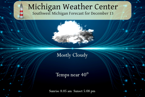
It will be dry today with gray skies once again. Highs will top out in the middle the to upper 30s in many areas. A wintry mix of precipitation is possible from early Wednesday morning into Thursday. The best chances for a mix will be across Central Lower Michigan. The system moving in from the west which is forecast to dump up to two feet of snow will be mostly rain when it gets here by Wednesday night dumping up to an inch of rain in SW Michigan.
7-Day Forecast 42.96°N 85.67°W 12 13
Forecast Discussion
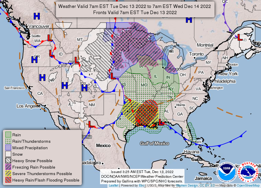
-- Mixed precip Wed and Thu; travel impacts possible --

A mature surface cyclone over northwest KS will occlude and become
vertically stacked this afternoon, then reach the vicinity of
northeast NE by 12z Wed. Precip occurring east of this system,
driven by QG forcing for ascent within the warm conveyor belt, will
continue eastward today, then approach Lower MI late tonight.
Recent model guidance suggests that this leading precip may
dissipate somewhat as it progresses into the forecast area on Wed
morning, owing to weakening forcing for ascent and considerable
low-level dryness evident in forecast profiles. However, renewed
cyclogenesis is expected to commence by Wed evening over the mid
MS valley, with most EPS members indicating a surface low reaching
central/northwest IN by 06z Thu. Preceding this secondary low,
deep-layer forcing for ascent will strengthen again over the
forecast area from Wed evening into Thu morning, and will likely
contribute to an increase in precip coverage/rates over the area
into Thu morning. Thereafter, as the secondary low continues
north/northwestward and occludes, an associated midlevel dry slot
will advance over Lower MI during the daytime Thu, likely bringing
an end to widespread precip.

Precip types, amounts, and related impacts remain the primary
forecast concerns during the Wed-Thu timeframe. As noted above, the
initial swath of precip on Wed morning may be eroded by subcloud
evaporation/sublimation. However, where precip reaches the surface,
a period of light freezing rain or sleet may occur, given that (1)
an elevated melting layer will be established prior to precip
arrival, and (2) near-freezing temps are expected on Wed morning.
With time, models suggest that the surface freezing isotherm will
advance northward on Wed, and any subsequent precip will fall as
rain where temps rise above freezing. At this time, any icing
amounts prior to 7 PM Wed are expected to remain light (trace to
0.02 inch). However, some slippery road conditions are still
possible with these amounts, with bridges/overpasses most prone to
icing.

The main risk for freezing rain still appears to exist from Wed
evening into Thu morning, and primarily north of a Whitehall-
Greenville-Alma line. Within this timeframe, ensemble probs of
subfreezing surface temps are highest in this area. However, in the
absence of appreciable surface cold advection and radiative cooling,
latent heating from any surface ice accretion will contribute to
warming, such that ice accretion will be self limiting. Within this
area, icing amounts between a trace to 0.20 inch are expected
through Thu morning. Freezing rain may transition to a period of
snow on Thu morning as the elevated warm layer is eliminated by
dynamical cooling, with expected snowfall ranging from a trace to
3 inches in this area. Given the possibility of travel impacts
from freezing rain and snow, a Winter Weather Advisory may be
needed for northern portions of the forecast area, but this
decision will be deferred to later shifts. Temps will likely rise
above freezing during the daytime Thu, easing travel impacts.

Lastly, RAP profiles from Wed morning into Wed night exhibit
occasional conditional instability for parcels in the elevated
warm layer (700-850 mb), yielding MUCAPE up to 200 J/kg. This may
may support sufficient riming for graupel at the surface within
any showery precip elements.

-- Lake-effect snow and turning colder Fri-Sun --

Global ensemble guidance continues to suggest that a post-
mature/stacked cyclone will be positioned near western Lake Superior
on Fri morning. This low should move gradually eastward during
the weekend, possibly being subsumed by an expansive circulation
associated with a deepening low over New England and the Canadian
maritimes. Given westerly, cyclonically curved low-level flow,
sufficient delta-Ts, and indications of appreciable low-level
moisture, lake-effect snow is expected from Fri into Sat night.
Anything but a quiet week of weather! In the next few days you will see, rain, wind, freezing rain, snow, colder temps and lake effect snow! It will be a wild week of winter weather! Incredible!
Wow! For the west end of Lake Superior:
URGENT – WINTER WEATHER MESSAGE
National Weather Service Duluth MN
139 PM CST Tue Dec 13 2022
MNZ020-021-140745-
/O.CON.KDLH.BZ.W.0001.221214T0000Z-221216T0000Z/
Southern Lake-Southern Cook-
Including the cities of Two Harbors, Silver Bay, and Grand Marais
139 PM CST Tue Dec 13 2022
…BLIZZARD WARNING REMAINS IN EFFECT FROM 6 PM THIS EVENING TO
6 PM CST THURSDAY…
* WHAT…Blizzard conditions expected. Total snow accumulations of
18 to 30 inches and ice accumulations of a light glaze. Winds
gusting as high as 45 mph.
Now that sounds wild!
Wow – another quiet day and then mainly rain the next 2 days.
The sun has been out here for the past 2.5 hours. What an unexpected surprise.
We had about 10 minutes of sun here… it was great while it lasted
Coldest Christmas day in years on the way? which means with a warm lake to our west snow snow and snow get ready folks ..INDY
I’m sure most of you saw that Bill Marino is retiring. He had my favorite forecast discussions. Thanks for his service!
It looks like next week finally turns colder, but nothing crazy cold (across the lake the highs will be in the single digits). Good thing we have Lake Michigan!
No one can write a forecast discussion like Marino. He will be missed.
Very monotonous hourly reports the last 3 days with the temperature barely moving at all between 32 and 38.
https://w1.weather.gov/data/obhistory/KGRR.html
We’re going on a three plus week stretch of boring, uneventful weather. Mild temps, hardly any precip, and lots of clouds. We are due to for a significant pattern change. I see that the Phoenix area is expecting frost, so the colder air is on its way.
Did you say pattern change? You will get your wish! Get ready for cold, snow and a white Christmas! Incredible!
I love these quiet and warm 3 week stretches!
We see you if you show up on here next week lol.. INDY
With a lot of clouds there was not much of a temperature spread yesterday. The official H/L at Grand Rapids was 35/33. There was no rain or snow fall and no sunshine. There remains no snow on the ground. The overnight low for today so far is 31. For today the average H/L is 37/25. The record high of 61 was set in 2015 and the record low of -6 was set in 1958. Today will be yet another cloudy day with highs mostly in the 30’s with dry conditions once again. East winds of 10 to 20 mph will… Read more »
Rapids the mean for the 1st 12 days of this month is 34.6 that is a departure of +1.8. there has only been 0.25” of total precipitation and of that just 0.8” of snow fall. At Lansing the mean is 35.3 for a So far December 2022 has been mild and dry with very little in the snow fall department. At Grand departure of +3.5 and they have recorded 0.27” of total precipitation and lead the way with 1.5” of snow fall. At Muskegon they have a mean of 36.9 that is a departure of +2.8 they only have had… Read more »