I overslept this morning, or did I? Darn time change anyway messing with my circadian rhythm. It’s a good thing I am retired so it won’t have much of an effect on my daily activities.
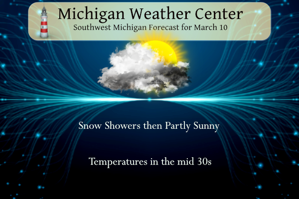
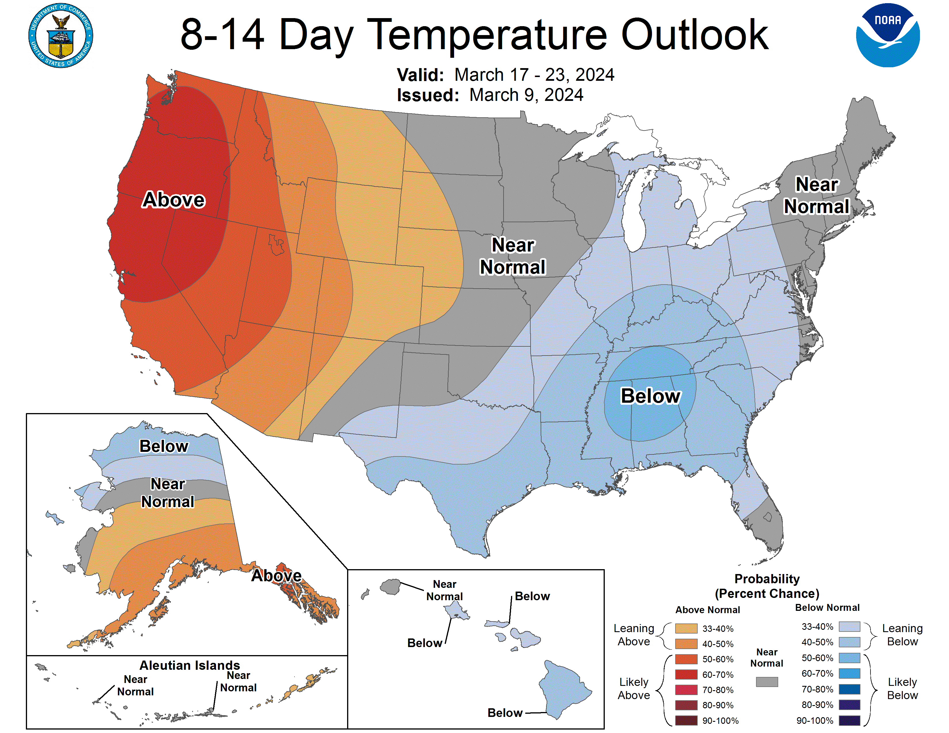
Snow showers will end this morning with little to no additional accumulation. Decreasing clouds will lead to more sunshine this afternoon. It will be colder today with highs in the upper 30s to around 40 degrees. A 15 to 25 mph northwest wind will make it feel much colder today. Dry weather is forecast for Monday and Tuesday with moderating temperatures. The CPC is guessing cooler than normal temperatures in the 8 to 14-day outlook.
NWS Forecast
Weather History
1901: An ice storm across southwest Lower Michigan caused thousands of dollars in damage, and paralyzed telephone, telegraph, news wires, and railroads. Streams were swollen as rain fell onto frozen ground, resulting in many washouts and accidents. Similar conditions were also reported for St. Joseph, Grand Haven, Ionia, Coldwater, and Kalamazoo.
1993: A snowstorm drops 6 to 8 inches of snow across southwest Lower Michigan. Record daily snowfall includes 6.2 inches at Grand Rapids and 6.4 inches at Muskegon.
On March 10, 1992, 6.9 inches of snow fell with a winter storm that moved through Flint.
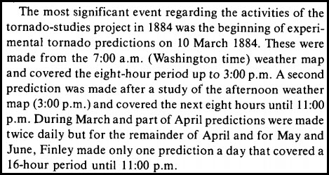
1884: John Park Finley issued the first experimental tornado prediction. Finley studied the atmospheric parameters that were present during previous tornadoes. Many of these same criteria are still used by operational forecasters today. However, the use of tornado forecasts would be banned just a few years later and remain forbidden until 1952. Click HERE for more information from the Storm Prediction Center.
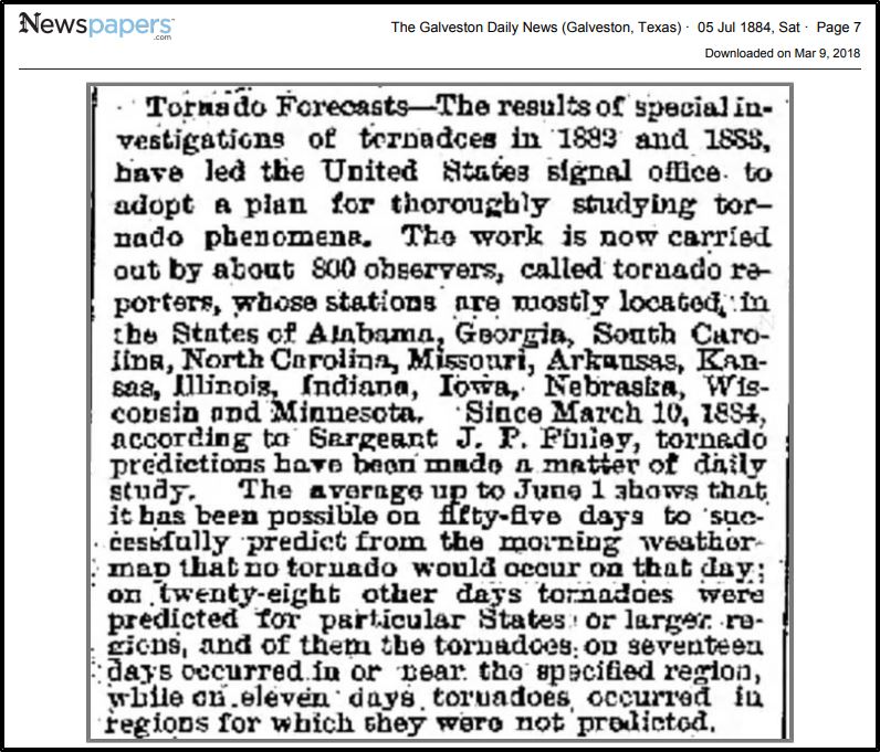
The newspaper clipping above is from The Galveston Daily News Galveston, Texas July 05, 1884, Sat • Page 7
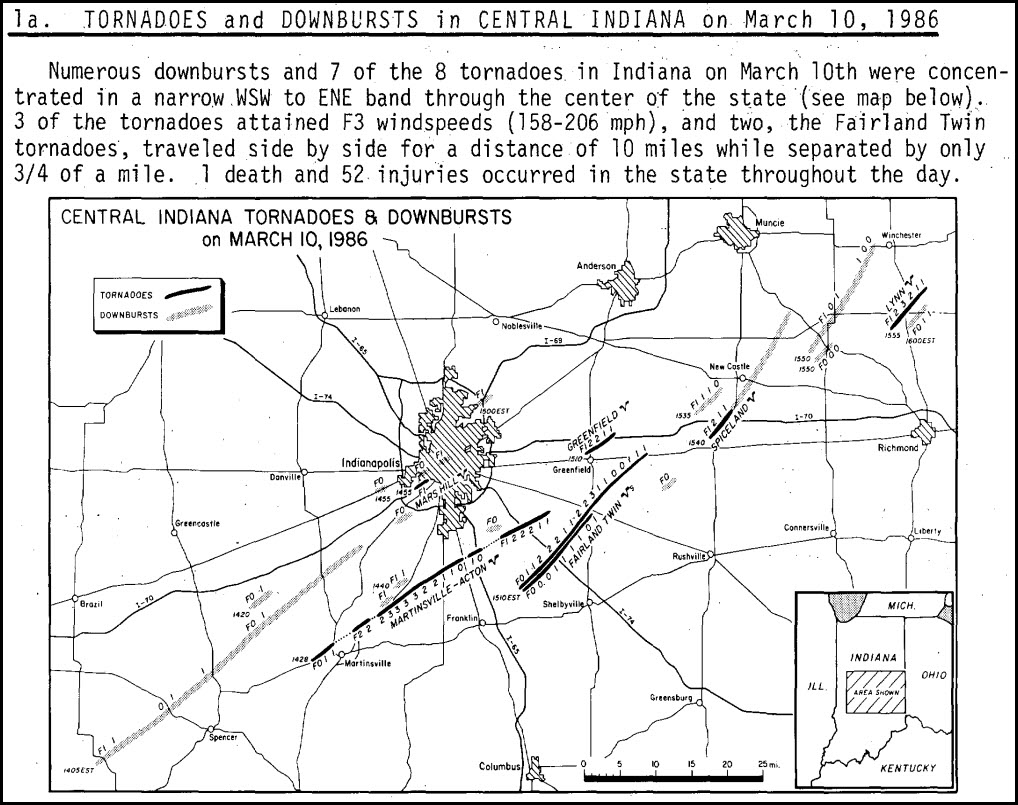
1986: Severe thunderstorms and tornadoes hit Indiana, Kentucky, and Ohio. A total of 19 tornadoes occurred. Three of the tornadoes in Indiana reached F3 intensity. A densely populated subdivision of Southeast Lexington, Kentucky, was heavily damaged by a tornado. Twenty people were injured, and 900 homes were destroyed or demolished. A very strong thunderstorm downburst hit the Cincinnati area. At the Greater Cincinnati Airport, windows were blown out of the control tower, injuring the six controllers on duty. At Newport, Kentucky, 120 houses were destroyed by winds estimated from 100 to 140 mph. Click HERE for more information about the Lexington, Kentucky, tornado from the NWS Office in Louisville.

Forecast Discussion
- Snow Ending by Mid-Day

The mid-level shortwave that is visible on water vapor imagery is
directly over lower Michigan early this morning. Scattered light
snow may bring an additional few tenths of an inch of
accumulation through this morning, resulting in a localized 1-2
inches near and north of Mason and Ocean Counties and in western
Allegan and Van Buren Counties. Overall impacts should be limited
but be prepared for isolated slick spots early this morning. Snow
will come to an end by mid-day as the upper trough departs east
and upper level support goes away.

- Warm and Dry Start to The Work Week

High pressure fills in quickly behind the upper trough beginning
another warming trend with dry weather. Tonight will start out
cold with skies clearing out. Radiational cooling pushes lows into
20s tonight but temps will rebound quickly Monday with highs in
the 50s, though wouldn`t be surprised to see temps overperform
with full sunshine. Renewed southwest flow supports further
warming into Tuesday and Wednesday with highs hitting the low to
mid 60s.

- Precipitation chances increase mid to late week

A zonal upper flow pattern is in place mid week which transitions
into a deep trough next weekend. Mid week only minor shortwaves are
forecast within the zonal flow so precipitation chances are rather
small. Stronger shortwaves aloft are noted over the Great Lakes in
the Thursday and Friday time frame ahead of the upper trough that is
beginning to develop upstream over the Northern Plains.

At the surface a weak boundary is located in the Great Lakes region
Tuesday night through Wednesday night. Little in the way of focus
for precipitation is present with the weak front however so we only
have 20-30 percent chances for rain showers in the forecast.
Thursday into Friday a low will move along the front although there
are differences in the location of the boundary. The GFS is further
north into our area with the front, while the ECMWF has a further
south placement. In either case, rain showers look likely especially
across Southern Lower Michigan. The GFS would bring in just enough
instability (850mb LIs around 0 to -1C) for some thunder. We do have
a mention of thunder in the south towards I-94 Thursday night.

Regarding temperatures...highs from mid week into next weekend will
transition from the 60s on Wednesday to the lower to middle 40s on
Sunday with upper troughing settling in overhead.
Technically today isn’t *that* cold for March 10 (3 degrees below average)… but wow it sure feels chilly!
Snow in Mach Is a bonus isn’t it supposed to be Spring?? Asking a friend Lol… INDY
What? You mean winter is not over! Who would have thought? Some said winter was over back in December! Wow!
+1000 INDY
What a cold March weekend! More to come by the end of next week! Forget about temps in the 70’s, forget about temps in the 60’s and get ready for a lot of cold March days! Wow! Incredible!
The 1st 9 days of March 2024 are now the 2nd warmest for the start of March. The mean here for the 1st 9 days of March was 46.0 that is 2nd only to March 1983 when the 1st 9 days had a mean of 48.5.
Slim
Along with the time change the weather also changed and for the 1st time this month there is a trace of snow on the ground. The overnight low was 29 and the current temperature is 30.
Slim
We have 1/2 inch of fresh beautiful white SNOW! i love it!
The official H/L yesterday at Grand Rapids was 47/30 there was 0.20” of rainfall and a trace of snowfall. The highest wind gust was 29 MPH out of the W. There was 7% of possible sunshine. For today the average H/L is 42/25 the record high of 69 was set in 1894 and the record low of3 was set in 1972. The wettest was 0.68” that also had 2.9” of snowfall. The most snow on the ground was 16” in 2024. Last year had the record snow fall of 8.7” and the H/L was 37/29.
Slim