
This post is to help to jump to the defense of meteorologists long range forecasts. Generally forecasts for a current day can be assumed to be close to 100% correct, however they can lose that percentage as the hours and days increase. As I have written in previous posts our atmosphere is like a large ocean and the swirls and currents can change. Our Mets do the best they can with the data they have at any given moment to predict what is going to happen at any given location. Most of this data comes from computer models and can be only guesses at best as they move past a couple days.
The Butterfly Effect refers to instances where small variations in initial conditions in a system can result in significant changes later down the line.
The Butterfly Effect was originally ‘discovered’ in simulations of weather prediction. Researchers found that minute changes in the initial pre-conditions would yield extremely different results as the simulation progressed. However, the Butterfly Effect can be seen in simple systems as well as complex systems – the height and position from where a bouncy ball is dropped will have a significant impact on its pattern of movement thereafter.
In a mathematical context, the butterfly effect is an important idea in chaos theory and it is commonly phrased as a ‘sensitive dependence on initial conditions.’ Chaotic events are those in which outcomes can’t be calculated despite the fact that incremental steps can be predicted and measured.
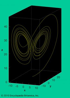 The Butterfly Effect is named after the most common example, which is the formation of a severe hurricane being dependent on whether a single butterfly had fluttered its wings days or weeks earlier. It was named by American mathematician Edward Norton Lorenz, known as the father of chaos theory.
In the early 1960s Lorenz discovered that the weather exhibits a nonlinear phenomenon known as sensitive dependence on initial conditions. He constructed a weather model showing that almost any two nearby starting points, indicating the current weather, will quickly diverge trajectories and will quite frequently end up in different “lobes,” which correspond to calm or stormy weather. He explained this phenomenon, which makes long-range weather forecasting impossible, to the public as the “butterfly effect”: in China a butterfly flaps its wings, leading to unpredictable changes in U.S. weather a few days later.
As bizarre as it may sound, if I say that a butterfly flapped its wing in Brazil, and a tornado took place in Chicago, that’s what the theory states. Note that the butterfly in Brazil did not directly cause the tornado. A flap is simply a change in the present state, which gives rise to further events. Once that chain is complete, which the butterfly started, a tornado takes place in Chicago. In short, perturbations created by them give birth to a major happening.
So, before you take out your frustrations on inaccurate futurecasts in the weather by your local Met keep in mind that a butterfly or even a flock of barn swallows downstream can cause changes in the weather pattern meaning small changes in a weather pattern can have major effects downstream.
Our cooler than normal temps will continue on through most of the rest of the month according to the CPC and things should start to dry out (hopefully). We could see some heavy rain and rumbles of thunder today…
Seven Day Forecast
Pollen Forecast
The below normal temps just keep rocking! Let’s keep it up?
I’m thinking last time my furnace ran this late in May was 1997 Slim …It’s 57* degrees outside YARDOFBRICKS NE GR now temps are cooling off now till next week or the week after …INDY!!
Here is a list of the current warmest temperatures so far at the major stations around Michigan. Grand Rapids 77, Lansing 76, Kalamazoo 76, Battle Creek 76, Muskegon 80, Detroit 76, Detroit City 74, Flint 74, Saginaw 76, Alpena 76, Houghton Lake 77, Sault Ste Marie 70, Pellston 72, Traverse City 80, Marquette 65, Houghton 69. So far the only locations that have had temperatures to reach 80 have been locations that have a tendency for down slopping that makes their temperatures warmer.
Slim
What’s the highest you’ve recorded by your house?
I did get to 81 on April 22 that is the warmest day I have recorded so far this year. But my readings are not official both for the summers highs nor the winters coldest low.
Slim
“THEORY”…sure, imagine anything you like. Spending your day dreaming about riding a Unicorn, helps Hollywood develop more Comic Book Characters for our theatres. The real world is such a scary, cold, storm-free place to spend your time. Hey, that sounds like Mi (aka, The Southern Arctic)
Not very comfortable working outside today with dew points into the 60s. Hope this isn’t another Summer of sweat with high dew points again like last year. That was just the worst.
Are we in the midst of another storm-free spring?
It sure looks like it.
Slim
In terms of how few warm days GR has had so far this year. 2019 will have the latest first 80° of the 2000’s in fact the last time GR had its first 80 day later was in 1997. At this time it is dark off to the NW and the current temperature here at my house is 49
Slim
And a few of the above lovers maybe on vacation for a lot longer then we think lol….INDY!
Seems odd GR has not hit 80 while surrounding areas have. Maybe not all official, but even here I’ve recorded an 81 already.
I found this interesting stat Slim you will like this GR has had the same amount of 40*degree day’s as we have had 60*degree day’s this spring not making a lot of leeway yet on the warmth I guess if you like 50’s your in business probably why the blog has been so quiet lately lol …With the cooler temps I have not saw one butterfly yet this spring…Have a good Thursday… INDY!!
GR has not seen a lot of very warm days yet this year. Yes we have had several days were the temperatures have reached the 70’s Here it the break down for Grand Rapids for 2019 70° days 5 that is 4 in April and 1 in May. 60° days 13 1 in March, 10 in April and 2 here in May so far. and that is it,
Slim