
I put up a new squirrel feeder close to our new webcam – you build it and they will come (feature image)
Our rainy pattern will continue through Thursday with 1 to 2 inches possible on top of what we have already had. Thunderstorms are possible tonight and tomorrow, however at this point I am not seeing anything severe. It does appear we may have a chance to dry out next week which will give a chance for the fields to dry out so the farmers can start plowing.
Weather History
May 5
1895: An early season heat wave peaks with record highs of 96 degrees at Grand Rapids and 92 at Lansing. The 96 degrees at Grand Rapids is a record for so early in the season.
May 6
1902: A tornado injures two people and destroys several barns east of Maple Rapids in Clinton County. Another tornado destroys several barns near Tekonsha in Calhoun County.
May 7
1947: Cold and snow prevail across Lower Michigan with lows in the upper 20s and highs only in the upper 30s to lower 40s.
1974: Temperatures tumble as cold high pressure builds into Lower Michigan. Record lows on this date include 22 degrees at Lansing, 25 at Grand Rapids and 27 at Muskegon.
May 8
1976: A freeze hits Lower Michigan with Grand Rapids and Muskegon setting record lows of 27 degrees.
1880: A tornado destroyed two homes and a barn two miles east of Kalamazoo. No one was injured.
May 9
1923: A very late season winter storm dropped up to a foot of snow across Lower Michigan. Records were set for May snowfall at many places including Lansing with 11.5 inches, Grand Rapids with 5.5 inches, and Detroit with 6 inches.
1927: About 40 farm buildings are damaged or destroyed as a tornado moved from near Loomis in Isabella County, across southeast Clare County and into Gladwin County. Another tornado destroyed two barns and damaged two homes three miles west of Walker.
May 10
1902: A snowstorm drops from 1 to 6 inches of slushy snow across Lower Michigan. The four inches of snow at Muskegon is the latest measurable snow on record there
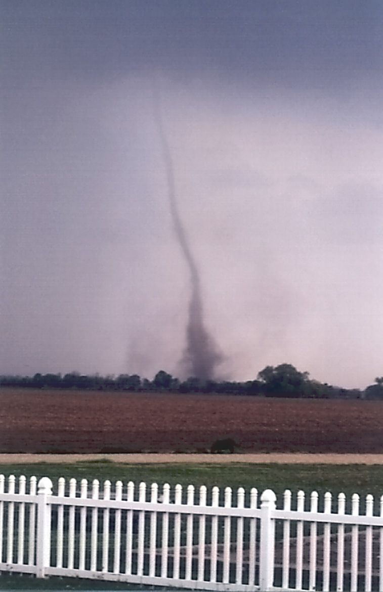
2006: A small weak tornado, determined to be a “landspout” moved through an open field near Schoolcraft in Kalamazoo County, doing no damage. (image below)
May 11
1956: A tornado hit the northeast edge of Kalamazoo, damaging 15 homes and destroying several barns.
Seven Day Forecast
Pollen Forecast
This is only the beginning of the “new” non-stop cold. 2019…unfortunately, the coldest we’ve known of 🙁 Reality has a nasty reputatuon for getting in the way of ideology. I know, I know, our lakes are boiling, and our trees are melting.
We are well on our way to a 5th straight month of below normal temps! How is that possible after all of the warm weather hype this past winter? Incredible but it goes to show you that FACTS actually do matter!
Well I guess location matters more, because last month over here towards the lakeshore we were actually above average, therefore putting our streak of below normal months in a row at zero.
Barry the Holland Tulip AP now has had 4 months in a row of below average temperatures. January -3.2. February -1.6, March -4.0 April -1.0 and the first 7 days of May are now at -4.4. So while Muskegon did manage to come in at +0.5 for April Grand Rapids and Holland and Lansing are all 4 months in a row of below average temperatures to start 2019.
Slim
Facts get in the way of the warm weather hype again! I love it!
Gr baby – 4 months and counting!