The NFC championship between our Lions (14-5) against the 49s (13-5) is on at 6:30 pm on Fox. GO LIONS!
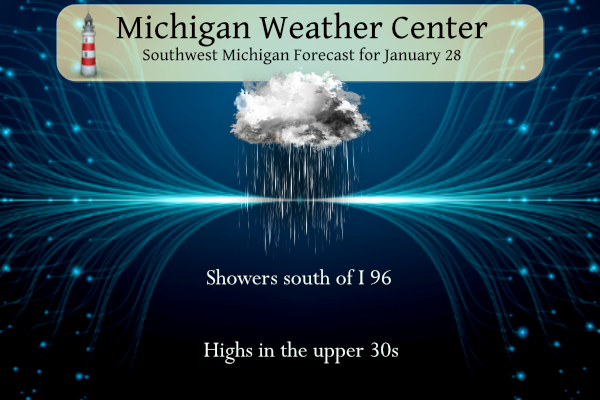
We will see mostly cloudy conditions today with rain and snow south of I96. High temperatures will remain above freezing so our thaw continues.
Forecast
Weather History
1977: Buffalo, New York is hit with the worst blizzard in its history. Meanwhile, lake effect snow squalls also pummel areas in western Lower Michigan with more than a foot of fresh snow being piled into huge drifts by strong winds.
On January 28, 2019, a winter storm impacted the area with the Thumb and Tri-Cities region receiving 7 to 10 inches of snow. The system ushered in the coldest air of the season in its wake with dangerous wind chills occurring for the couple of days following.
On January 28, 1906, Saginaw had a record-high temperature of 47 degrees. For all the record highs recorded in the month of January, this temperature was the lowest. All other record-high temperatures for the month varied between 50 and 62 degrees.
U.S.A and Global Events for January 28th:
1887: Snowflakes “as large as milk pans” fell at Fort Keogh of Montana. The flakes, which were said to measure 15 inches across and 8 inches thick, hold the unofficial size record!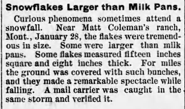
1969: Heavy rains of tropical origin that began on 1/18 ended on this day. As much as 50 inches of rain fell at 7,700 feet. 31 inches of rain fell on the south slopes of Mt. San Gorgonio, 15.5 inches at San Jacinto Peak, around ten inches at Banning, less than one inch from Indio southeast. 91 were reported dead from flooding and mudslides all over California and state-wide.

The image above is from a tweet by the NWS Office in San Diego, California.
1977: The Blizzard of ’77 was one of the worst winter storms to hit southern Ontario and upstate New York. With the rapid onset of the storm, about 2,000 students in the Niagara region were stranded overnight in schools. Click HERE for more information from Gray Roots and Museum.
1986: The Space Shuttle Challenger broke apart at 11:39 am EST, 73 seconds after liftoff from the Kennedy Space Center at Cape Canaveral, Florida, on a frigid morning. Starting in the 20s, the ground temperature at liftoff was 36 degrees. Morton Thiokol recommended not launching if the liftoff temperature was below 53 degrees. The cold was blamed for causing the O-rings on the Shuttle’s external booster to fail, leading to the explosion. Low-level wind shear also played a factor. Click HERE for more information from the History Channel.
Forecast Discussion
- Patchy Fog, Rain, and Snow into Today

No major changes needed to the going forecast in the first part of
the period through Monday.

Precipitation in the form of mainly rain has spread north to roughly
a line from Holland to Alma as of 330 am this morning. Most of the
precipitation has been light thus far, with a couple bands of
enhanced precipitation being observed SE of Grand Rapids.

The period in which we are likely to see the rain change to snow
will be over the next few hours mainly SE of I-69. This will be the
case as the strongest bands will be there as the upper low lifts NNE
and the best deformation occurs in that area. The snow will likely
be mostly a result of the heavier precipitation rates given the low
level thermal fields being close to the rain/snow. Another factor
will be some slightly cooler temps there and with the slight change
in terrain of the Irish Hills.

Even with the changeover to snow, this event will not be a prolonged
one as it appears that most, if not all of the precipitation will
have moved out by 18z this afternoon. Also, sfc and road temps in
the mid 30s will prevent this from becoming an ice event as it melts
on contact. We are still looking at an inch or so on grassy/elevated
sfcs.

Once the precipitation moves out this afternoon, we should remain
most dry then through Monday as ridging builds in. Don`t expect a
lot of sunshine under the ridge as plenty of low level moisture will
stick around and keep low clouds/fog in place underneath the
strengthening subsidence inversion.


- Clipper brings rain/snow Monday night through Tuesday night

Precipitation during the long term will fall from Monday night
through Tuesday night.  A strengthening upper short wave will move
SSE across western Ontario Monday and drop into Michigan Monday
night. This is a little more northerly trajectory than the usual
clipper track that tracks from Montana to the Great Lakes. But
models have been latched onto this track for many days and so
confidence is high that we`ll see some precipitation from it.

Forecast soundings indicate that most of the thermal profile will be
subfreezing which points toward snow as the main p-type. However,
enough warmer air may mix in from the lake to cause mixed rain/snow
over the western counties. Snowfall accumulations around an inch
seem look plausible given the 0.15 qpf and snow ratios less than
10:1.

Surface temperatures will be around freezing and could result in
some slick spots, especially considering that recent rainfall may
have washed road salt off the roads. However, this isn`t a major
system by any stretch and impacts won`t be either.

Highs will be in the 30s except for Thursday and Friday when lower
40s are possible.
Let’s go Lions!
Even if the season ends tonight, it’s one us fans will never forget – especially us OLD fans. 😄
Storm Team 8 broadcast on this date from 10 years ago (1/28/14). We were in one of the coldest points of the winter at this stage. Grand Rapids just came off a record low for the date at -9. As stated in the afternoon broadcast Craig James called in a temp of -23.
Morning:
https://m.youtube.com/watch?v=EFXbt3jkGYg&pp=ygUVc3Rvcm0gdGVhbSA4IGphbiAyMDE0
Afternoon:
https://m.youtube.com/watch?v=ZA8RuxvoeR8&pp=ygUVc3Rvcm0gdGVhbSA4IGphbiAyMDE0
It was awesome!
No record or near record highs this month! So much for the blowtorch!
Blowtorch means a long stretch of well above average temps.
We’ve now had 4 consecutive days of double digit temps above average. Expect this to continue for some time. The blowtorch is on!
The official H/L yesterday at Grand Rapids was 38/33 there was 0.01” of rainfall. There was no sunshine and the day started out with a reported 1” of snow on the ground at GRR. For today the average H/L is 31/17 the record high of 53 was set in 1914 and 2002 the record low of -9 was set in 2014 the record snowfall of 6.0” fell in 1977 the most snow on the ground was 24” in 1978. Last year the H/L was 31/23 and there was 4” of snowfall.
Slim
While this long warm spell has not had any near record highs the lows have been in the top ten since January 23rd it has not gone below 32 since January 22nd There are now a lot of bare spots showing up in my yard.
Slim
Definitely warm enough to thaw and melt snow but certainly not a blow torch and no 50’s that the warm weather nuts were fantasizing about! Incredible!
How is that possible? We even have accumulating snow in SE Michigan this morning. Incredible!
Great comment Kyle!! Mookie is notorious for pointing out the weather in SE MI, if it is warmer over there! In fact it could be snowing and 30 degrees in GR and he posts a comment about the fact it is 40 degrees and raining in Detroit, so your comment is absolutely perfect!!!!
An extended temp of 10-15f above normal in the middle of July would probably be called a heat wave. It’s hard to deny we are much warmer than normal and personally I don’t like it. Currently, the relative temperature isn’t a “heat wave” or “blow torch”. But it is definitely an extended warm-up. MBY still has about 4-5” of snow everywhere. No bare spots yet. But my long 1/4 mile driveway is entering the dreaded “mud phase”.
Correction: MBY has 3”. A lot more melted overnight.
I would not call this a “blowtorch” I really do not like that term even in the summer. While there have not been any near record highs this month as the highest so far is just 38. But then there has been a lot of cold rain and the lows have now been above 32 for 6 nights in a row.
Slim
Spot on! Far from a blowtorch! Warm enough for continued snow melt and that’s about it!