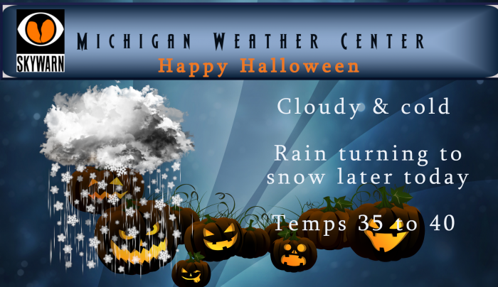
If one were to ask for perfect weather for Halloween they aren’t going to get it today, unless of course one was looking for the ‘perfect’ Halloween of wind, rain and snow of the traditional lore of horror stories. I was out this morning emptying my rain gauge in the cold pouring rain (we had just a bit over an inch in the past 24 hours) thinking of all the poor kids and their parents who will be out and about tonight trick or treating.
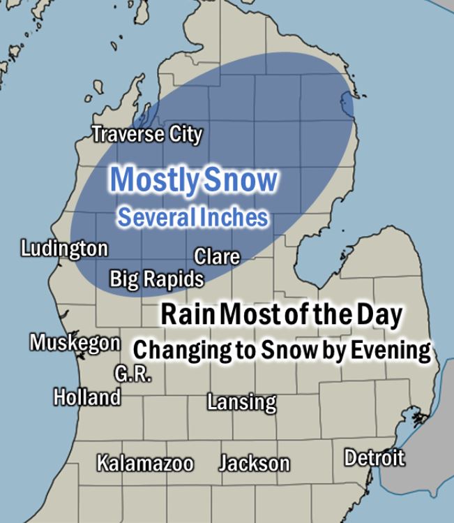
Yesterday our high temp was 39° with wet snow in the morning turning to all rain during the day – today will be a rerun…
We have all sorts of advisories and warnings today:
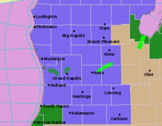
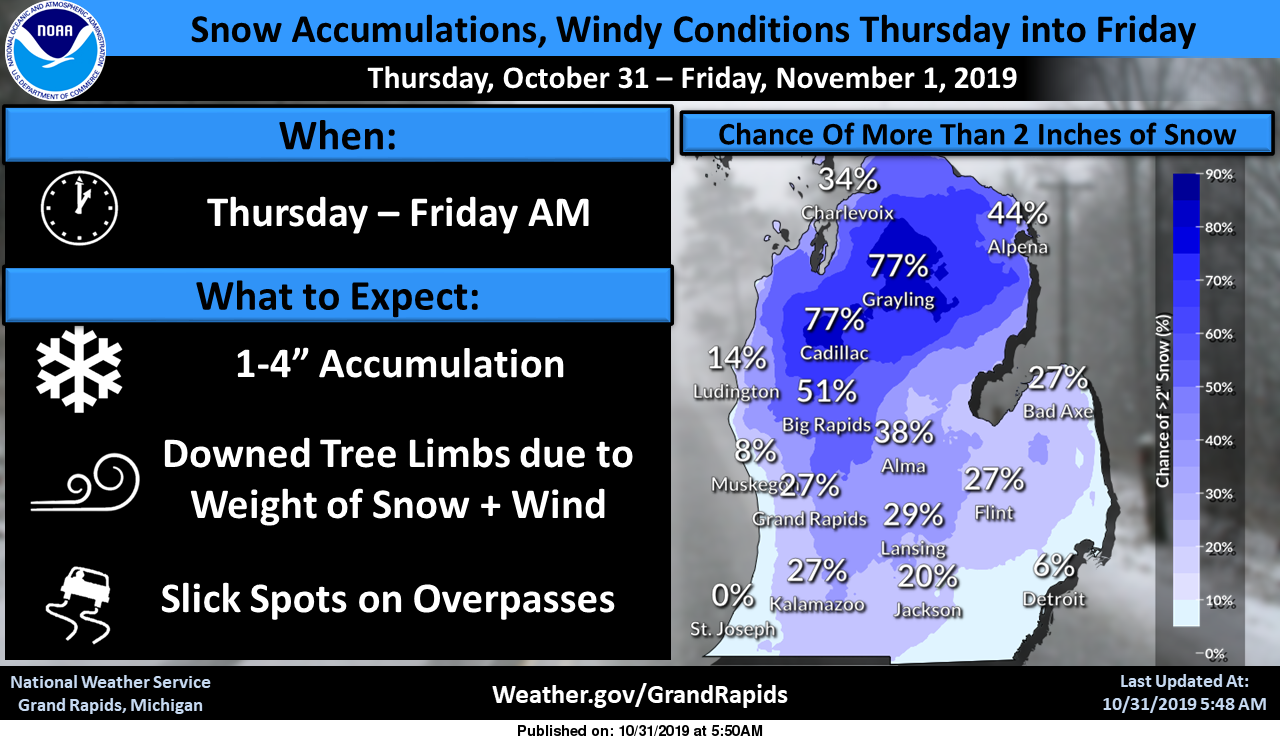
...WINTER WEATHER ADVISORY IN EFFECT UNTIL 8 AM EDT FRIDAY...

* WHAT...Snow. Total accumulations of 1 to 3 inches. Lesser
  accumulations on roadways. Snow possibly sticking to trees.
  Winds gusting as high as 50 mph.

* WHERE...Portions of central, south central and southwest
  Michigan.

* WHEN...From 2 PM Thursday to 8 AM EDT Friday.

* IMPACTS...Slippery roads during the evening commute. Power
  outages can be expected with strong winds and sticky snow in
  trees.
...WIND ADVISORY IN EFFECT FROM 5 PM THIS AFTERNOON TO 11 PM EDT
THIS EVENING...

The National Weather Service in Grand Rapids has issued a Wind
Advisory...which is in effect from 5 PM this afternoon to 11 PM
EDT this evening.
In summation it will not be pleasant for the last day of October – so bundle up in rain gear and boots if you are going out today.
Now were are continuing with the lessons on synoptic meteorology – there will be a test so pay attention….
Air Masses

An air mass is a large body of air with generally uniform temperature and humidity. The area over which an air mass originates is what provides its characteristics. The longer the air mass stays over its source region, the more likely it will acquire the properties of the surface below. As such, air masses are associated with high pressure systems.
There are two broad overarching divisions of air masses based upon the moisture content. Continental air masses, designated by the lowercase letter ‘c’, originate over continents are therefore dry air masses. Maritime air masses, designated by the letter ‘m’, originate over the oceans and are therefore moist air masses.
Each of the two divisions are then divided based upon the temperature content of the surface over which they originate.
- Arctic air masses, designated by the letter ‘A’, are very cold as they originate over the Arctic or Antarctic regions.
- Polar air masses, designated by the letter ‘P’, are not as cold as Arctic air masses as they originate over the higher latitudes of both land and sea.
- Tropical air masses, designated by the letter ‘T’, are warm/hot as they originate over the lower latitudes of both land and sea.
Putting both designations together, we have, for example, a “continental arctic” air mass designated by ‘cA’, which source is over the poles and therefore very cold and dry. Continental polar (cP) is not as cold as the Arctic air mass but is also very dry. Maritime polar (mP) is also cold but moist due to its origination over the oceans. The desert region air masses (hot and dry) are designated by ‘cT’ for ‘continental tropical’.
As these air masses move around the earth they can begin to acquire additional attributes. For example, in winter an arctic air mass (very cold and dry air) can move over the ocean, picking up some warmth and moisture from the warmer ocean and becoming a maritime polar air mass (mP) – one that is still fairly cold but contains moisture.
If that same polar air mass moves south from Canada into the southern U.S. it will pick up some of the warmth of the ground, but due to lack of moisture it remains very dry. This is called a continental polar air mass (cP).
Air mass boundaries
The motion of air mass motion is usually based upon the air flow in the upper atmosphere. As the jet stream changes intensity and position, it affects the motion and strength of air masses. Where air masses converge, they form boundaries called “fronts”.

Fronts are identified by change of temperature based upon their motion. With a cold front, a colder air mass is replacing a warmer air mass. A warm front is the opposite affect in that warm air replaces cold air. There is also a stationary front, which, as the name implies, means the boundary between two air masses does not move.
The motion of air masses also affects where a good portion of precipitation occurs. The air of cold air masses is more dense than warmer air masses. Therefore, as these cold air masses move, the dense air undercuts the warmer air masses forcing the warm air up and over the colder air causing it to rise into the atmosphere.
So, fronts just don’t appear at the surface of the earth, they have a vertical structure or slope to them as well. Warm fronts typically have a gentle slope so the air rising along the frontal surface is gradual.

With warm fronts, the gentle slope favors a broad area of rising air so there is typically widespread layered or stratiform cloudiness and precipitation along and to the north of the front. The slope of cold fronts, being much more steep forces air upward more abruptly. This can lead to a fairly narrow band of showers and thunderstorms along or just ahead of the front.
There is another boundary that exists except this boundary divides moist air from dry air. Called a dry line this boundary will separate moist air from the Gulf of Mexico (to the east) and dry desert air from the southwestern states (to the west).
It typically lies north-south across the central and southern high Plains states during the spring and early summer. The dry line typically advances eastward during the afternoon and retreats westward at night.
Halloween
Just about every year I relate some personal stories of haunted houses – whether you believe it or not there is a realm we know little about where earthbound spirits exists or the remnants of what they left behind. Out east there are many haunted houses and cemeteries some are very old. I lived in an old Victorian house in Maine back in the 70s – (it was torn down a couple decades ago) – I lived on the third floor where most of the strange happenings occurred – my friends wouldn’t spend the night because of the hauntings. There were also two old cemeteries in town where the spirits would chase one off from the premises. I also lived in a house in Hopkins where my ex-wife and I saw the spirit of an uncle of the people who owned the house – that one was mischievous and up close and personal.
I have seen a lot of strange things through the years – if you would like to relate a story in the comments feel free….
Well that was a laughable advisory. A few wet flakes mixed in the rain for an hour or two amounting to absolutely nothing. Did have a bit of rain though, 0.83”. Should have been a rain advisory.
We usually get 75 or so trick or treaters. We maybe got a dozen tonight. Miserable out. Wet and windy. Little bit of snow on the grass. I don’t think it will be measurable when it’s all said and done.
Currently 35* degrees wind and moderate snow falling out at thee YARDofBRICKS NE of GR …. Halloween Spooky weather ….INDY
Who knew?
Happy Halloween! Snow!
Nice map. Shows zero snow from mid Ottawa county to the West. Nothing but rain here.
The rain has just changed to snow here, maybe still a mix. The current temperature is now at 36
Slim
At this time no snow is falling here at my house and the current temperature here is at 39
Slim
Here is the current color report
https://www.foliagenetwork.com/index.php/foliage-reports/foliage-reports-midwest-us/current-season-midwest-us/129-foliage-reports/foliage-reports-midwest-us/foliage-reports-midwest-us-current-season/914-mw-foliage-report-16-2019
It looks like this year is one of the latest years going back to 2008 with last year 2017 and 2013 also being very late. I can not say this year is the latest in the great lakes history but it is later than average. If you want to look up other years back to 2008 here is the site
https://www.foliagenetwork.com/index.php/foliage-reports/foliage-reports-midwest-us/foliage-reports-midwest-us-archive
Slim
Halloween… guaranteed to be one of the worst weather days in MI. Hauntings?…nonsense. Nothing more than your imagination processing fragments of input, to reach a conclusion you’ve already decided you want.
Winter?…as stated earlier, the word is Catastrophic. Non-stop snow accumulation, with perpetually deepening cold well into, and through 2020.
Lkview Michigan I’m eating lunch at my sister’s ice cream shop for the time this season it’s 35* degrees with light snow falling sure don’t look like Halloween outside…INDY
The WWA has been expanded to include us. Trick or treating will not be fun tonight.
Ready for the quiz MV!
A fairly wet October with 6 and a half inches of rain, but well below just 2 years ago when we had 9 and a half inches of rain. It’d be nice to have some sun to see the tree colors, right at peak now. Heading into November with A lot of trees that are still green.
Not sure if this year is the latest for the leaf drop or not but it sure is later then average that is for sure,
Slim
Good Morning. At this time there is a cold rain falling here at my house and the current temperature is at 38°. Yesterday the official H/L at Grand Rapids was 41/34 and there was 0.2” of snow fall at the airport. Here at my house there was some snow mixed in with the rain but that was it. For today the average H/L here at Grand Rapids is 55/38. The record high is 79 set in 1950 and the record low is 20 set in 1988. Last year the H/L was 57/42
Slim
What? Snow on Halloween and a WWA! Who would have thought? Incredible!
I do not know for sure but that could be a first. The WWA that is.
Slim
I hope people have been listening to us about the possibility of a snowy and cold Halloween coming MODELS have been a 100% correct we nailed it and yes a first for a WWA!! On Halloween amazing..INDY
Let it snow let it snow ..INDY
Extream weather alerts put out today we have had some storms going back to around the first of the year! 2019 has been a destruction year for a lot of people in Michigan and it keeps going amazing it’s Halloween and we have a Winter Weather Advisory in effect now shuu and after today GR will have over 8 inches of rain probably another record set for the month of October extremely wet Fall..Looking ahead I was just seeing some MODELS around the 8th of November showing highs temps only in the 20’s coldest daytime highs ever for around that… Read more »
Yes and all of this on top of a below temp pattern extending all the way back to the beginning of this year! What a great pattern heading into winter! Above precip and below temps = a rock n roll winter party!
Let it snow let it snow ..INDY