We have 55° at 6:30 this morning, 14° warmer than this time yesterday. Yesterday we had a high of 68° and the low was 40°. We continue to forecast mild and dry conditions for the first half of this week followed by a cold front passing through on Thursday. This will send temperatures tumbling to below normal levels to end the week with a hint of a few wet snowflakes in the northern lower penninsula. Huh, a bit early for the ‘s’ word to enter our forecast.
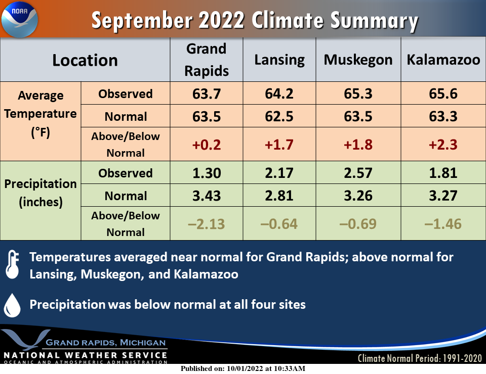
September precipitation was below normal, with near-normal to somewhat above normal temperatures. Here are the numbers from four observation locations.
Forecast Discussion
An upper level ridge will continue to build in from the west today
into early next week and result in a prolonged period of fair wx
with mostly clear to partly cloudy skies. Some patchy frost is
expected early Monday morning and perhaps again early Tuesday
morning with mostly clear skies and calm winds setting up
excellent radiational cooling conditions. Patchy fog is
anticipated early Monday morning as well. Large diurnals are
expected the next several days with the dry airmass in place and
lots of sun.

A strong cold front will bring a chance of showers by Wednesday
night and a better chance for a band of rain along and just ahead
of the front Thursday. North to nnw flow lake effect clouds and
showers are expected Thursday night and Friday. Forecast thermal
profiles suggest a few wet snow flakes may mix in at times mainly
across relatively higher elevations of our northern fcst area and
inland from relatively mild Lake MI waters. H8 temps will plummet
to -4 to -6 C by 00Z Sat.
It is beautiful outside!!
We’re outside of Chicago for homecoming for our daughter’s college. Her team got demolished yesterday but all of the homecoming activities have been great fun. The weather has been terrific this weekend. I should’ve used sunscreen. My face got fried yesterday.
Hope everyone has a nice Sunday! Looks nice and sunny today
You too.
Yesterday was a great start to October with the official H/L at Grand Rapids of 70/42. There was no rain fall and 100% of possible sunshine was reported. The overnight low and current temperature here at my house was/is 51. For today the average H/L has now dropped down to 67/47 the record high of 87 was set in 1971 and the record low of 27 was set in 1974. I would like to add for the month of September Grand Rapids had 51% of possible sunshine and there were a total of 4 thunderstorms.
Slim
A bid cold front will be coming through later this week! Get ready now!
Yesterday was yet another below normal temp day! The string of below normal temps keeps going and going and going! What an incredible cold stretch we are in and no change is in sight! Bring on winter!