
Yesterday we had a quick shower pass through bringing us .13 of an inch of rain. Our high temp was 83° with a 74° dewpoint. Today we have had .40 of an inch of rain so far with an overnight low of 72° (at 6 am).
The juicy air will stick around today with temps in the mid to upper 80s and dewpoints in the mid-70s. Severe weather will be possible both today and tomorrow. The best chance each day will come late in the afternoon and evening hours I suspect most areas will remain dry until after 7 pm. The main threats will be gusty winds and locally heavy rainfall. Some large hail will also be possible. Below are the SPC outlooks for today and tomorrow.
[columns] [span6]
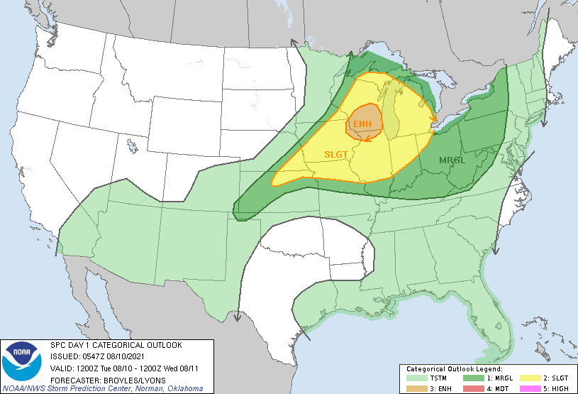
Day One
[/span6][span6]
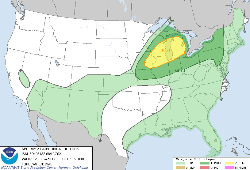
Day Two
[/span6][/columns]
Forecast Discussion
- Strong/Severe storms still possible this week

Occasional rounds of thunderstorms will continue until the cold
front moves through late Thursday. This latest round of heavy
rain and strong storms have so far missed us to the south.
Training of thunderstorms with extremely high rain rates resulted
in over 7 inches of rain in parts of Berrien County. We do not
expect much in the way of significant storms this morning or even
into this afternoon as shortwave ridging occurs in between the
departing trough and the next one arriving this evening.

We are in a slight risk for today and Wednesday based on the
juicy airmass and diurnal heating resulting in CAPE values of 3500
to 4000 J/kg this afternoon and evening and again on Wednesday as
shortwave troughs move through the base of upper troughing
extending south from central Canada. Shear values are in the 20 to
25 knot range so storm mode is expected to be pulse type storms
and perhaps a few bow echoes given unidirectional wind shear,
which is strongest on Wednesday evening.

So the greatest chance for storms will be this evening and again
Wednesday afternoon and evening, but confidence is low on the
details due to poor model consistency. A final batch of showers
and thunderstorms is possible Thursday morning across the southern
forecast area as the cold front moves through.

- Cooler and much drier this weekend

Dew points will crash from the 70s to the 50s by the end of the
week with Canadian high pressure providing a comfortable and fine
weather weekend as upper troughing keeps the hot and humid air
suppressed to the south and west. We will have to watch future
model trends of the northward progress of a recurving tropical
cyclone, which some of the westernmost ensemble members bring into
the Great Lakes early next week.
We have lost our power.
83 here at 11p. Thank goodness for a/c. I just heard that 150k Michiganders are without power. It will be an uncomfortable night for those folks. The line heading my way is fizzling. Hoping we at least get a decent downpour.
It’s knocking on your door. Hope you get the rain you want We did.
Can you believe it? We were under a severe thunderstorm warning and not one drop of rain and no thunder. Windy, but that’s all.
Yeah, there are a LOT of power outages looking at the consumers map. We had some pretty decent wind gusts and some quick, heavy rain, but only amounted to just over a quarter of an inch. Ton of lightening all around though!
https://www.consumersenergy.com/outagemap
Very windy, lots of lightning and heavy rain.
Per Mark Torregrossa: “I’ve only seen an 80 degree dew point in Michigan twice in the last 25 years.”
So yes, what we are experiencing right now is very rare.
Storm moving in here. Lights blinking. We got flashlights out. Let’s hope we don’t have a power outage.
Getting moderate amount of lightning to the west at this time. It is still very warm here with a temp of 85 and a dew point of 78. latest DP at GRR is 79
Slim
NWS Grand Rapids
@NWSGrandRapids
·
13m
Severe Thunderstorm Warning including Muskegon MI, Holland MI, Norton Shores MI until 11:15 PM EDT
That’s crazy. Severe thunderstorm warnings pretty much from Traverse City all the way down the coast to Gary, IN. I don’t think I have ever seen that.
I am under a T storm warning till 11:15PM
It’s Summer…it’s warm…enjoy. 25 degrees will soon be here for seven months.
Sounds absolutely awesome! Bring it!
A watch will be issued for lower Michigan soon. At this time the temperature is 86 here with a dew point of 77.
Slim
the watch is now issued until 3 am
Slim
UPDATE… Issued at 740 PM EDT Tue Aug 10 2021 Over WI, it`s been quite an imbalance between very strong instability (MLCAPE greater than 4000 J per kg) and very weak shear (0-3km bulk less than 20kt). However it looks like things are starting to gel together a bit more so a more contiguous cold pool can develop. Also, there is recent quick development over IL in even greater instability – and surprisingly this appears more balanced and may bring our greatest risk for damaging winds. The HRRR is aggressive in maintaining rather intense convection into Lower MI, but we… Read more »
Dew point here is now 79.5. I don’t know of to many (if any) times I have recorded a DP of 80 here.
I found a site that I can look up past DP’s in. The highest I have found for GR is 81. But this is nothing like that time as the air temp then was 94 and the heat index was 120 that was in 1995.
Slim
Sounds like a good find for past data.
Highest dew point in Florida right now is 81. Highest dew point in Michigan right now is 82. Holy smokes!
http://www.usairnet.com/weather/maps/current/florida/dew-points/
125 million Americans under some sort of heat advisory/warning. It’s hot coast to coast.
Ugh. Can’t wait till this is gone!
Ditto. This is miserable. Looks like the high humidity should move out for the weekend. But still, 80s in the forecast for the next couple of weeks.
MD for us. Watch is coming.
https://www.spc.noaa.gov/products/md/md1468.html
I love summers with no heat waves! Keep it coming!
Just another day GR does not hit 90 degrees! Get ready for the cold front! Incredible weather!
In the storms to our west at this time the worst of the lightning is west of Chicago and up in the Green Bay area. So there may not be much lightning with the rain coming tonight. Maybe the Grand Rapids storm dome continues
Slim
The temperature here is now at 87 with a DP of 78 that is good for a heat index of 100. Officially at GRR the 7 PM readings were.
Humidity 75%
Wind Speed SW 9 mph
Barometer 29.86 in (1010.3 mb)
Dewpoint 77°F (25°C)
Visibility 10.00 mi
Heat Index 97°F (36°C)
Last update 10 Aug 6:53 pm EDT
That is with a air temp of 86.
Slim
7:10 pm and my PWS just hit 90 with a heat index of 101.7. Yuck!
https://www.wunderground.com/dashboard/pws/KMIZEELA26/graph/2021-08-8/2021-08-8/daily
At this time I have a temperature of 88 and a DP of 77 that is good for a heat index of 100. Officially at GRR they have a temperature of 86 with a dew point of 75 good for a heat index of 95. To the east at Lansing the temp is 89 DP 70 Heat index is 94.The highest DP seem to be here in SW Michigan. At Sturgis the current DP is a reported 81 with a heat index of 104.
Slim
I don’t even want to know what the heat index is here at work right now. Inside temp where I’m at right now is 108 degrees. And yes it is accurate as I just calibrated the thermometer this morning.
Dew point is up to 77 here! It is just plain HOT! Highest dew point in Michigan right now is an unbelievable 81!
http://www.usairnet.com/weather/maps/current/michigan/dew-points/
The DP here at my house is now at 77 also. I have some past DP records that I will post on Saturday
Slim
Nice link. I see an 82 on the map. Even 70 at Copper Harbor. Very impressive.
It’s a hot one today. 90 here now. Triple digit heat indices in Grand Ledge and Hillsdale. The dew point in Hillsdale is 79.
The DP reached 80 a few minutes ago for a ‘feels like’ temp of 102 – air temp is 87. ’nuff said’
CPC shows this warmth continuing! How can this be? I love long summers!
Seeing future cast west Michigan maybe getting a line of big storms this afternoon into the evening I’m thinking watches coming ….INDY
Well here at my house there was some lightning last night but there was no rain. 0.30″ of rain did fall at the airport. The overnight low both here and at the airport was 71 at this time it is cloudy and 75 here with a dew point of 71. The last days have been warm and for this area very humid. So while NOT a heat wave it has been more like a humid wave. But the case can be made as to why there is no long term records keep for the dew points.
Slim
We got a little rain overnight with a couple of rumbles of thunder. My lawn is getting crispy and our son asked if I was going to water it. I said no. Autumn will be here soon, and I am ready for that. School starts two weeks from today. We will have two high schoolers – one senior and one freshman.
Last night around midnight we heard thunder rumbling and it started lightning. It rained but not for long. Not much of a thunderstorm.
Good morning MV’S best currently as of 830am Fort Myers beach Florida 79* dgreres heat index 83* and a dewpoint of 76* sunny hot now that’s some early morning heat Slim…Check this out I have been here 3 days now and all 3 days we have had afternoon Thunderstorms from the heat of the day andi temps in the 90’s everyday very tropical down here just beeing here a week I will have more 90′ degree days Thunderstorms and now a possibility of a hurricane coming by the end of the week then in good old GR this whole Summer… Read more »
Daily thunderstorms are very common down there in the summer time. Even when there is not one right were you are there are storms not too far away on most summer days.
Here is the 10 AM report from Page Field
Humidity 75%
Wind Speed E 8 mph
Barometer 30.14 in (1020.9 mb)
Dewpoint 77°F (25°C)
Visibility 10.00 mi
Heat Index 97°F (36°C)
Last update 10 Aug 9:53 am EDT
Indy Page Field is right on US 41 (Cleveland street) near the bridge to Cape Coral.
Slim
Shuuu its probably the hottest day yet here Slim tnanks for sharing that with me ..INDY