I would have to say yesterday was the most tropical I have seen probably the last 20 years or more. We generally don’t have dewpoints in the 80° range. Last night was an especially thick air mass in place with dewpoints near 80 and air temps at 83.5° at 9 pm we had a ‘feels like’ temp of 95° before the wind gust line moved through.
Storms split as they came over the Otsego/Plainwell area with the worst of it moving south and north of the area. Some areas around here lost power mainly due to the wind at the leading edge of the rain.
According to the Consumers outage map, there are around 190000 homes without power this morning with Kent and Allegan County leading the list. Wind gusts were as high as 70 mph in some areas. Winds in the Dorr area reached close to 70 mph.
We only had .07 of an inch from last night’s storms and .40 from the storms after midnight yesterday. Yesterday’s high was 87° with an 81° dewpoint which gave us a feels like temp of 104°!
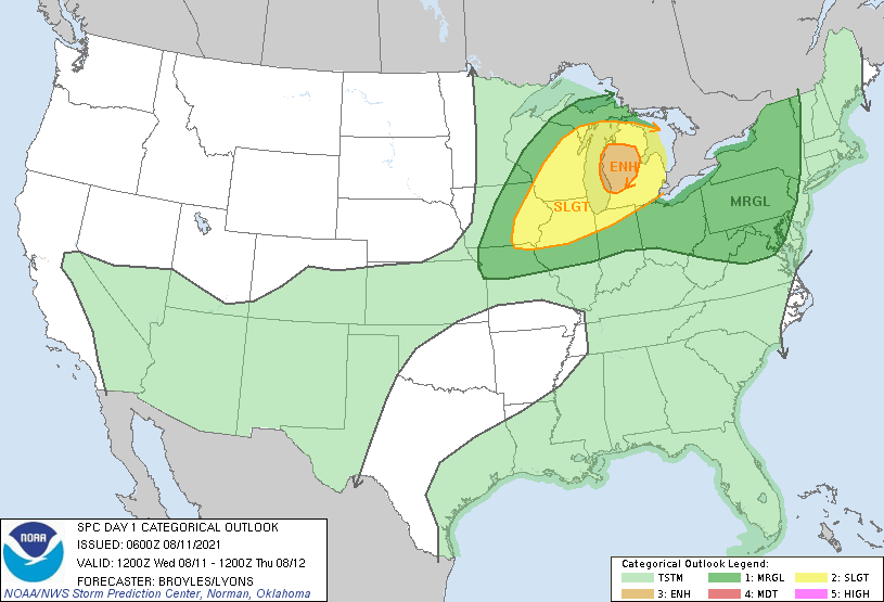
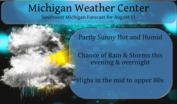
We have an enhanced risk of severe storms mainly this evening and overnight. We will see temps pushing into the mid-80s to near 90 once again with high dewpoints.
Forecast Discussion
- Another Round of Strong/Severe storms this evening

We are in a Enhanced Risk for severe weather this evening as an
MCS is expected to move into northern Lower Michigan in the late
afternoon and move southeast into a juicy airmass with CAPE
values of 3000 to 4000 J/kg and deep layer shear values around 30
knots. This environment could support both strong downdrafts from
multicell pulse storms as well as bowing lines and even a few
discrete supercells ahead of the main batch of storms.

The time frame is expected to be from around 6 pm across the
northern zones to 9 pm across the south, give or take a couple
hours. Although rain rates could be very high given p-wats around
2 inches, MBE vectors show storm motion around 20 knots in the
evening and the likelihood of cold pool generation and
maintenance also indicates the forward progress of storms with
heavy rain should be great enough to limit the flood threat.

- Fair and cooler for the weekend

Showers and thunderstorms are possible again on Thursday as the
cold front moves through. There is a marginal risk of severe
weather at this time. Dew points will crash from the 70s to the
50s by the end of the week with Canadian high pressure providing a
comfortable and fine weather weekend as upper troughing keeps the
hot and humid air suppressed to the south and west. We will have
to watch future model trends of the northward progress of a
recurving tropical cyclone early next week, but the vast majority
of ensemble members currently keep the rains associated with it to
the east of the Great Lakes.
Two strikes overhead…nice and loud. I’ll take what I can get.
Another thunderstorm watch issued. Funny thing is when the MD was posted earlier, the chance of a watch was only 20%.
No wind and not much rain, but the light show is worth it. Enjoy 😉
🤘
The thunder and lightning are something else! The last strike felt too close!
Yes, this is one intense lightening storm!
Oh to live N, S, W, or E of Ada…the weather desert.
This has became the biggest thunderstorm of the summer so far here. With off and on heavy rain and some good thunder strikes.
Slim
Got some training storms going over my area now! Vivid lightning and heavy thunder!! This is a good one!
What is the purple that flashes on our radar page? Does anyone know what it means?
Ha, my wife was asking the same thing. I told her it’s because it’s a monster storm. 😉
Monster storm? lol!!
The rain has just started here. There is some lightning off to the north and west. So far nothing heavy. Temp is now down to 75 with a DP of 69
Slim
Still no power and the estimated time for it to be working again is not until Friday noon! Horrendous!
Same here. I think the crews are overwhelmed. Just read that over 600,000 people are out across the state.
What a potent little storm just reaching the shore 😉
No 90’s today?? if that’s the case I believe we are 2 months since our last 90* degree day such alongnnn stretch crazy it’s been into the 90’s since I flew in last Saturday down here in Florida!! INDY
It’s a lot like this past winter when we had zero snowfall from February 27th on thru the rest of winter!
Well the sun was shining for awhile but now it is getting darker again. Storms were in Grand Haven I thought they said.
Severe warned storm just came through. My office faces the front of our house. Big gust and the tree across the street just split in two. Five minutes of high winds, sheets of heavy rain, and some lightning. Now, it is very quiet.
Wow! Did you see the tree come down?
I did! I was looking over the top of my monitors as sky darkened and all of a sudden, WHOOSH, half is on the ground and the other half is still standing.
Cool to watch as long as there’s little or no damage. I just drove down our road and there’s trees down all over with power lines littered everywhere.
WOW!! That is either exciting or scary depending how you look at it. Did lightning hit it?
Not lightning, just high winds.
Well, not a very severe storm that just went through, but now our power is out. Time to fire up the generator just to keep the house cool. This humidity is just down right ridiculous!
Not much of a storm I agree.
Power on by you? Just checked the Consumers map and it is a very large area knocked out.
No they only blinked.
Currently working so I don’t have time to look into the details, but I’m surprised we are already getting storms? Hopefully no impact to the system for later this evening.
Wed, Aug 11, 2021, 12:51 PM EDT THE NATIONAL WEATHER SERVICE IN GRAND RAPIDS HAS ISSUED A * SEVERE THUNDERSTORM WARNING FOR… NORTHWESTERN ALLEGAN COUNTY IN SOUTHWESTERN MICHIGAN… OTTAWA COUNTY IN SOUTHWESTERN MICHIGAN… * UNTIL 145 PM EDT. * AT 1250 PM EDT, A SEVERE THUNDERSTORM WAS LOCATED OVER BEECHWOOD, OR NEAR HOLLAND, MOVING EAST AT 50 MPH. HAZARD…60 MPH WIND GUSTS. SOURCE…RADAR INDICATED. IMPACT…EXPECT DAMAGE TO ROOFS, SIDING, AND TREES. * THIS SEVERE THUNDERSTORM WILL BE NEAR… ZEELAND AROUND 100 PM EDT. HUDSONVILLE AND ALLENDALE AROUND 110 PM EDT. JENISON AROUND 115 PM EDT. OTHER LOCATIONS IMPACTED BY THIS… Read more »
Local tv met at noon said it may be a double whammy – the complex down to the southwest this afternoon, and then another round late tonight from the northwest.
It’s crazy looking at the Consumers Energy outage map. If tonight is anything like last night, lots of folks will be waiting many days for power restoration. Keeping my fingers crossed. At noon, I see there’s already a storm heading across the lake in my direction. Dang.
Local news said between Consumers and DTE, there are more than 300k customers without electricity.
Two items of note. 1. Severe thunderstorm watch as Mark stated to 5PM and 2. Dew Point is back up to 77 here at this time.
Slim
Severe thunderstorm watch until 5p
Enjoyed the gust last night…was relaxing on the driveway waiting for its arrival. No thunder/lightning for Ada, and the gust snapped one of our 75 foot trees in half. Chainsaw fun this weekend! Hoping everyone has power.
With hazy sunshine the temperature is now up to 79 here and the DP here is at 75. At GRR the last reported temp there was 79 with a DP of 73.
Slim
Some good storms and then clear skies? The meteor shower peaks tonight!
the latest from the SPC

Severe thunderstorms are likely across the Midwest and Great Lakes, especially across portions of Wisconsin, Illinois, and Michigan this afternoon and evening. Isolated strong to severe storms capable of wind gusts will also be possible across parts of the central/northern Appalachians and Mid-Atlantic states. …Midwest/Great Lakes… After an active Tuesday, another severe storm-favorable setup is in place across the region again today, with a more notable influence today of stronger winds aloft and more appreciable forcing for ascent (by mid-summer standards) as compared to yesterday, particularly for northern portions of Illinois/Indiana northward into Wisconsin/Michigan. An initial early day concern is… Read more »
After spending the night in the “dark ages” I am now back to 2021. Officially at GRR the highest dew point reached 79. The highest hourly heat index was 98 at 8 PM with a temp of 86 and a dew point of 78. Here at my house the highest DP was 78. Now for the storms last night. Here at my house I recorded 0.25″ of wind blown rain. It was very windy and while there was a good bit of lighting there was no thunder with it. Some of what seemed like lightning might have been transformers as… Read more »
I see a Heat Advisory for parts of Lower Michigan again today. Phew!
Look at all the heat advisories/warnings:
https://www.weather.gov/
Remember last night when I said the line was quickly fizzling as it approached us? We were under a severe thunderstorm warning, yet we received not one rumble of thunder or even one drop of rain. However, a nearby reporting station recorded a 60 mph wind gust. That was a pretty cool system to track, though.
Wow. Dew points in the 80’s throughout Michigan yesterday! That’s something we see maybe once once every 10 or 20 years. CPC keeps the heat on.
Per Mark Torregrossa: “I’ve only seen an 80 degree dew point in Michigan twice in the last 25 years.”
So yes, what we are experiencing right now is very rare.
Back in July of 1995 Grand Rapids had back to back days with dew points in the 80’s I will be doing a report on some past high dew point numbers on Saturday. They may surprise you as they did me.
Slim
That’s 26 years ago. It sounds like Mark T was right then when he said 25 years.