For those of you interested in the science of snow here ya go:
Snow cover is a part of the cryosphere, (where water is in solid form), which traces its origins to the Greek word kryos for frost. Snow is precipitation in the form of ice crystals. It originates in clouds when temperatures are below the freezing point (0 degrees Celsius, or 32 degrees Fahrenheit), when water vapor in the atmosphere condenses directly into ice without going through the liquid stage. Once an ice crystal has formed, it absorbs and freezes additional water vapor from the surrounding air, growing into a snow crystal or snow pellet, which then falls to Earth.
Snow falls in several forms:
- Snowflakes are clusters of ice crystals that fall from a cloud.
- Snow pellets, or graupel, are opaque ice particles in the atmosphere. They form as ice crystals fall through supercooled cloud droplets, which are below freezing but remain a liquid. The cloud droplets then freeze to the crystals, forming a lumpy mass. Graupel tends to be soft and crumbly.
- Sleet is composed of drops of rain or drizzle that freeze into ice as they fall, and is sometimes called a wintery mix of rain and snow. These small, translucent balls of ice are usually smaller than 0.76 centimeters (0.30 inches) in diameter. Official weather observations may list sleet as ice pellets. In some parts of the United States, the term sleet can refer to a mixture of ice pellets and freezing rain.
- One form of precipitation, hail, while frozen, is not considered snow. Hail tends to be larger than sleet, and is usually generated during thunderstorms, which happen more often in spring and summer than in winter. Hailstones form when upward moving air, or updrafts, in a thunderstorm prevent pieces of graupel from falling. Drops of supercooled water hit the graupel and freeze to it, causing the graupel to grow. When the balls of ice become too heavy for the updrafts to continue supporting them, they fall as hailstones.
Snow as mineral
Because snow is composed of frozen water, or ice, it can also be classified as a mineral. A mineral is a naturally occurring homogeneous solid, inorganically formed, with a definite chemical composition and an ordered atomic arrangement. Ice is naturally occurring, given a temperature below 0 degrees Celsius (32 degrees Fahrenheit). It is homogenous (of one material), formed inorganically, and has an ordered atomic structure. Ice has a definite chemical composition (H20), with hydrogen and oxygen atoms bonding in a specific manner.
Snow’s effect on climate
Seasonal snow is an important part of Earth’s climate system. Snow cover helps regulate the temperature of the Earth’s surface, and once that snow melts, the water helps fill rivers and reservoirs in many regions of the world, especially the western United States. In terms of area, snow cover is the largest single component of the cryosphere, covering an average of about 46 million square kilometers (about 17.8 million square miles) of Earth’s surface each year.
About 98 percent of the Earth’s snow cover is located in the Northern Hemisphere. On such a large scale, snow cover helps regulate the exchange of heat between Earth’s surface and the atmosphere, or the Earth’s energy balance. On a smaller scale, variations in snow cover can affect regional weather patterns. For instance, in Europe and Asia, the cooling associated with a heavy snowpack and moist spring soils can shift the arrival of the summer monsoon season and influence how long it lasts.


We reached our high temperature of 58° early this morning before the cold front blew through. It was still 60° when I went to bed at 10pm last night. The wind is the big factor throughout the state today. Along the lakeshore there are a lot of reports of winds over 50mph. I see Grand Rapids had gusts to 53 – East Tawas had a report of 61mph. The wind will be calming down after sunset tonight.
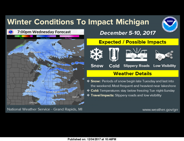
The snow moving in will be confined to the Gaylord area north to the straits where there is a winter storm warning – 5 to 10 inches of snow are forecast along with the wind. We may see a few flakes of snow around as temperatures drop to around 34 near sunset. We have a better chance of seeing the white stuff Wednesday afternoon in south Michigan – the heavier snows will begin late Friday on through the weekend – some of the models are showing it coming in Thursday night with 3 inches of accumulation along the lakeshore counties – of course this is dependent on where the lake effect bands set up.
Cool and intersting post, MV.
60° at midnight, 40° at 9am, and 30° now. That’s one heck of a cold front.
Some our Christmas lights have blown free from the house. I think I’ll wait until the wind dies down before I deal with that.
WOW what a pattern change! Bring on the cold and a TON of SNOW! Snow country in NW Lower will be getting hammered! Snowmobiling and skiing here I come!!!!!!!!!
Hello Traverse City and there will be tons more after this weekend! Incredible!
http://wxcaster.com/gis-gfs-snow-overlays2.php?STATIONID=GRR
Well, got the tree mess all cleaned up, cut, and stacked. This is the perfect weather to work cutting up trees. You get so hot and overheated doing this work, it just sucks trying to do it if the temp is over 50 or 60 degrees. As for the snow, I don’t know. The air is sure looking dry again, much like the past several years, we just have not been getting good lake effect snows. Combine that with the wind direction the past few years has been just right that it has skipped this area more often than not.… Read more »
3 or 4 Alberta Clippers coming in the next week should just enhance the snowfall over the great lks snows will be piling up temps are falling 33* now out at thee YARDofBRICKS..stay warm INDYDOG!!
Climatology for today December 5th At Grand Rapids, MI The average H/L 38/27 (30 year ave) 38.2/26.0 (120 year ave) The record high for today is 69° 2001 69° is also the record high for December the lowest Maximum high is 21° set in 2008 The record low is +4° set in 1964 and the warmest minimum is 54° set in 2001’ The most precip was 1.23” in 1999 The most snow fall was 7.7” in 1991 the most on the ground at 7 AM was 10” in 1940 Last year the H/L was 39/28 there was a trace of… Read more »
Yesterday’s official high was 61° while not a record high it is good for 3rd place with only 2012 at 65° and 63° in 1941 being warmer. Last night’s thunderstorm only dropped 0.7” of rain here, of course we don’t see too many December thunderstorms around here. Right now, here at my house I have a temperature of 39° that same reading is being reported at the airport. The winds are out of the SW at around 20MPH with some gust of around 35 MPH Not sure how much in the way of snow we will see in the next… Read more »
The next 7 days look pretty bone dry, especially if you aren’t right by the lake. The snow drought continues.
With the dry air one has to wonder how much snow will fall even near the lake and if that will be the pattern this winter?
Slim
Well for all the hours and hours and money I spent on equipment this year taking down about 30 dead ash trees around the house, one of the taller ones further away from the house came down last night, right onto my daughters car! Smashed out the back window, but not to many other dings or scratches. Looks like I’m spending the day cutting yet more wood to add to our pile that is going to last at least 10 years. And with the weak Winters we’ve been having, we aren’t burning much so it might last longer than that!
Aw man, that stinks. I’ve seen several downed trees in the area today.