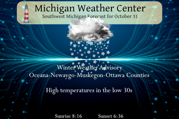
Moderate to heavy snow with rates around 1 inch per hour at times will result in hazardous travel conditions from northern Ottawa to Oceana and western Newaygo Counties. Isolated power outages will be possible in the areas of heaviest snowfall. Lighter snowfall amounts of around an inch are expected outside of these counties. Trick-or-treaters will need to bundle up with wind chills in the 20s!
...WINTER WEATHER ADVISORY IN EFFECT FROM 8 AM THIS MORNING TO
MIDNIGHT EDT TONIGHT...

* WHAT...Snow expected. Total snow accumulations of up to 6
  inches. Locally higher amounts possible especially around New
  Era.

* WHERE...Oceana, Newaygo, Muskegon and Ottawa counties.

* WHEN...From 8 AM this morning to midnight EDT tonight.

Forecast
U.S.A and Global Events for October 31st:
1876: The Great Backerganj, also known as the Bengal Cyclone of 1876 struck Bangladesh, then part of the province of Bengal in British India on this day. A maximum wind speed of 137 mph along with a storm surge of 10 to 45 feet inundated the coastal region. This storm likely caused 200,000 casualties along with displacing thousands of other individuals.
1991: A severe winter storm, dubbed the Great Halloween Mega Storm, struck the upper Midwest. Minnesota bore the brunt of this storm. Blizzard conditions occurred with winds gusting frequently to 40 and 50 mph. By the time it was all over on November 2nd, Duluth recorded 37 inches, Minneapolis 28 inches, International Falls 18 inches and 11.2 inches in 24 hours at Sioux Falls, SD, their earliest heavy snowfall of 6 inches or more and snowiest October on record. For Duluth and Minneapolis, the snow amounts set new all-time records for the greatest amount of snow in a single storm. The storm gave these two cities nearly half of their average seasonal snowfall.
Forecast Discussion
-Periods of Heavy Snow this afternoon and evening

 Periods of heavy snow showers coupled with gusty winds will
allow poor visibility and poor travel conditions for the evening
commute and for trick-or-treating children, especially for regions
north of Muskegon.

 The 00Z HREF and subsequent models continue with the bullseye of
higher QPF and snow amounts that coincide with the passage of a
SFC low, the track of the 700mb low and the 700-500mb
frontogenesisgive good credence to the 1" HR snowfall rates.
Limiting factors for snowfall is the daytime temperatures, the
warm ground and potential for low snow ratios and that the heavy
snow will compact quickly. The southwesterly flow across the lake
will bring upwards of 20 m/bars that will further enhance
instability.

 The areas of biggest concern for heavy snowfall is Oceana,
Muskegon and Newaygo counties. There will be an axis of heavy QPF
and period between 15Z to 21Z where these counties are beneath
the left exit region of the incoming 500mb Jet streak. That will
create strong dynamics. Couple with this with a good period is a
deep DGZ and snowfall could reach upwards of 6 inches with some
outlying ensemble members showing slightly higher amounts. Any
snow that falls will melt though the higher snowfall rates will
allow for the heavy wet snow to accumulate, especially on grassy
surfaces. Regions east of US 131 could receive snow but will be
a dusting to a few tenths. So while snow this time of year is
rare, it does occasionally happen. Measurable snow in Grand
Rapids in October has happened 5 times since 2000.

 Cold overnight lows Tuesday night into Wednesday are expected as
the system moves eastward. SFC low will shift southward with
lingering snow expected in Van Buren county as the system moves
eastward early Wednesday.

-Period of Dry Weather Through Friday

-Unsettled Pattern With Rain Chances This Weekend Into Next Week

There could be some lingering light snow in Van Buren and Allegan
counties Wednesday morning, otherwise dry conditions are expected
through Friday. Temperatures warm up each day as we settle into
southwest flow toward the surface for the remainder of the workweek.

Friday night we move more into an unsettled pattern with increasing
precipitable water values, and multiple shortwaves moving through.
Rain chances through the weekend are more in the 20 to 30 percent
range, so not expecting any day this weekend to be a washout. As we
head into next week though ensemble guidance reflects a bit more
confidence in wet weather hence the higher chances mainly in the 50
to 60 percent range. There are still some differences in timing that
far out, so would expect some adjustments to the forecast that far
out. Highs remain mainly in the 40s with lows in the 30s.
Just another ruined Halloween in the Southern Arctic.
Get used to it, because we have about 5 or 6 more months of winter weather! Wow, just wow! WOW!
I see reports of 9/10 inches of snow in Spring Lake/Fruitport area. Incredible Halloween storm!
Hard to see in the divide in the highway but looked like at least 4 cars maybe more in a pileup near Fruitport on my way back along with many slide offs. Passed a snowplow that drove off the highway and was being pulled out
Incredible storm and what a way to kick off the winter season! Keep it coming!
Let it snow let it snow let it snow …INDY
Numerous outages/traffic lights out in Muskegon. I measured 5” a while ago. I’d imagine easily 6-7” by now.
What a storm! A record setter! Incredible!
Blizzard Conditions along the lake shore many people without out power wow what a Halloween to remember for west Michigan…INDY
Who would have thought? Some of the warm weather fanatics said no cold and snow on Halloween this year! How wrong could they be?
Brrrrboooo happy Halloween MV’s best! INDY
.UPDATE… Main change with this update is to expand PoPs further inland this morning ahead of the main synoptic snowfall. Upper-level potential vorticity advection aided by an area of slightly negative EVPg is helping snow spread further inland with the initial lake effect. Stations like KMOP have reported light snow already this morning. The going advisory is in good shape as 12z HiRes guidance continues to promote a bullseye of QPF associated with additional moisture off of Lake Michigan through tonight over the 4 advisory counties. A general 3-6 inches of snow with locally higher amounts possible associated with mid-… Read more »
I am still in the Muskegon area and can relay a snowfall report on here. I’m on the east side of Muskegon along Apple Avenue and I just measured 5” on the ground.
Wow quite the band from Grand Haven to New Era. If it were mid-winter I’m sure there’d be some really impressive totals. Probably some 5+” totals eventually… the warm ground the sun angle might hold it back, not sure
US-31 near Muskegon getting snow covered. Be careful if driving in this area. Salt trucks should be coming out soon if not already.
Coming down like crazy at my location in Muskegon. Came here to pick a few things up to haul back to my house. Light dusting here so far.
The sun just came out here. Temperature is now up to 40 here and of course there is now no snow falling.
Slim
Crazy the difference. Someone sent me a picture who is in Lansing right now and lots of blue sky above at their location.
Here comes the SNOW! As long as it is a cold Halloween we might as well have snow! Snow is much better than a cold rain!!
Snow has just started here. But it is still warm with a temperature of 38. Whoops just like it started it has now stopped snowing so will call it a snow shower.
Slim
As much as I complain about the winter, I still always get excited every time it snows out. Even just a trace like today. I wish I lived in Muskegon… maybe the trend this winter will be heavier snow near the lake instead of along 131
What? Cold and Snow on Halloween? Could this be a sign of what’s to come this winter? Rock n roll will never die!
Let the good times roll!
The snow coming for areas northwest of GR is impressive for Halloween standards! Especially the areas that get 4-6inches of snow.
Right now it’s 34 and cloudy at my house.
Now as for some past Halloween weather conditions here in Grand Rapids The average H/L is 54/38 the record High is 79 set in 1950 and the record low of 20 was set in 1988. The wettest was in 1994 with 1.27” and the most snow fell in 1917 with 1.5”. Some other years with snow fall are 2017 with 0.4” 1932 with 0.3” and 2019 with 0.1” The coldest high was just 32 in 1917 other cold highs were 37 1996 and 1906 The high has reached 70 or better on ten Halloweens the last time was 1979 with… Read more »
Happy Halloween! The official H/L yesterday at Grand Rapids was 42/34. There was a trace of rain fall and no snow was reported. The sun was out 17% of the time and the highest wind speed was 31 MPH out of the W. The current temperature here in MBY is 36 degrees with cloudy skies. So at this time any snow that falls will not stick unless it falls very heavy.
Slim