We are now settling into a more near-normal pattern temp-wise. Yesterday’s high was 64° before dropping to 36° at midnight. Our current temp is 28° at 5:30 am. We have had 1.38 inches of precipitation (liquid) and 1.7 inches of snow for the month which brings us to 9.6 inches since November 1st.
Besides temps in the 60s, yesterday’s big story was the winds which in some areas were close to cat 1 hurricane speeds.
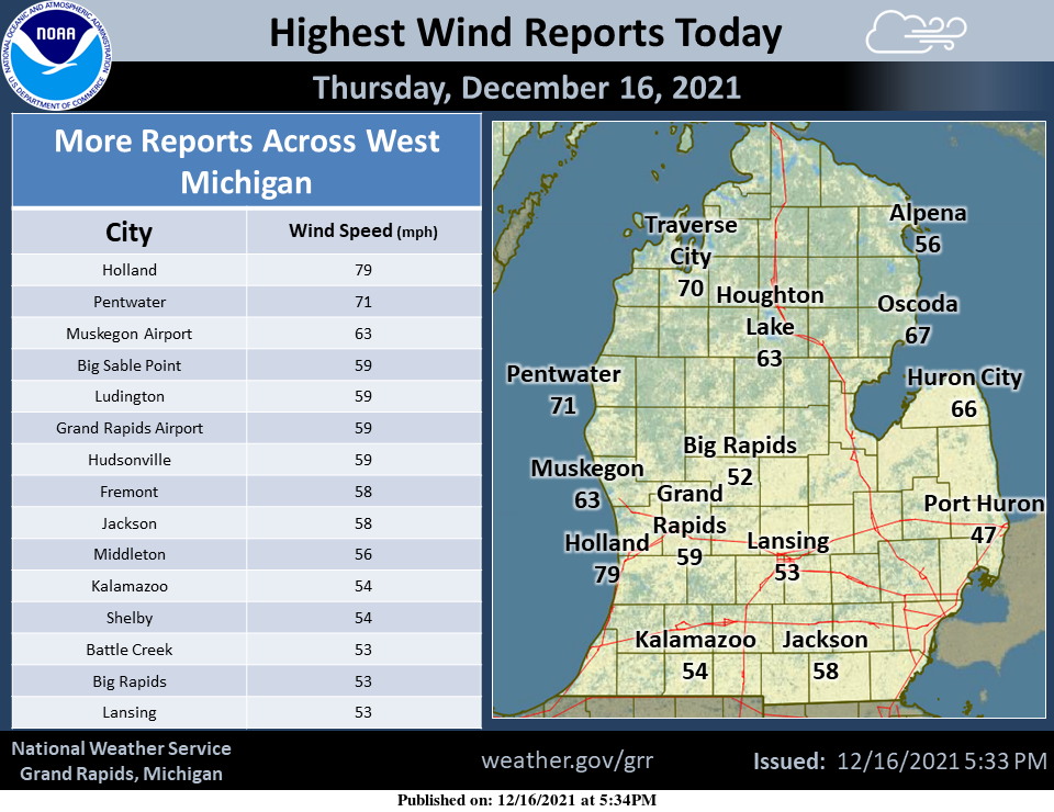
The chart here shows some of the highest wind gusts reported yesterday morning across West Michigan specifically, while the map shows some other reports across northern and eastern lower. As of 5 pm last evening, there are over 200k power outages across the state of Michigan (including the UP which is not shown on the map).
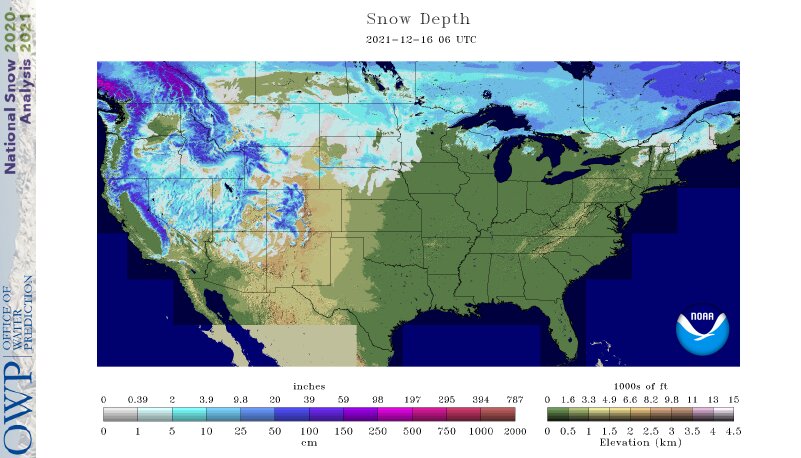
Looking at the snow cover for the lower 48 we have 29% with at least an inch of snow on the ground, we should see an increase in this over the next week coming up to Christmas.
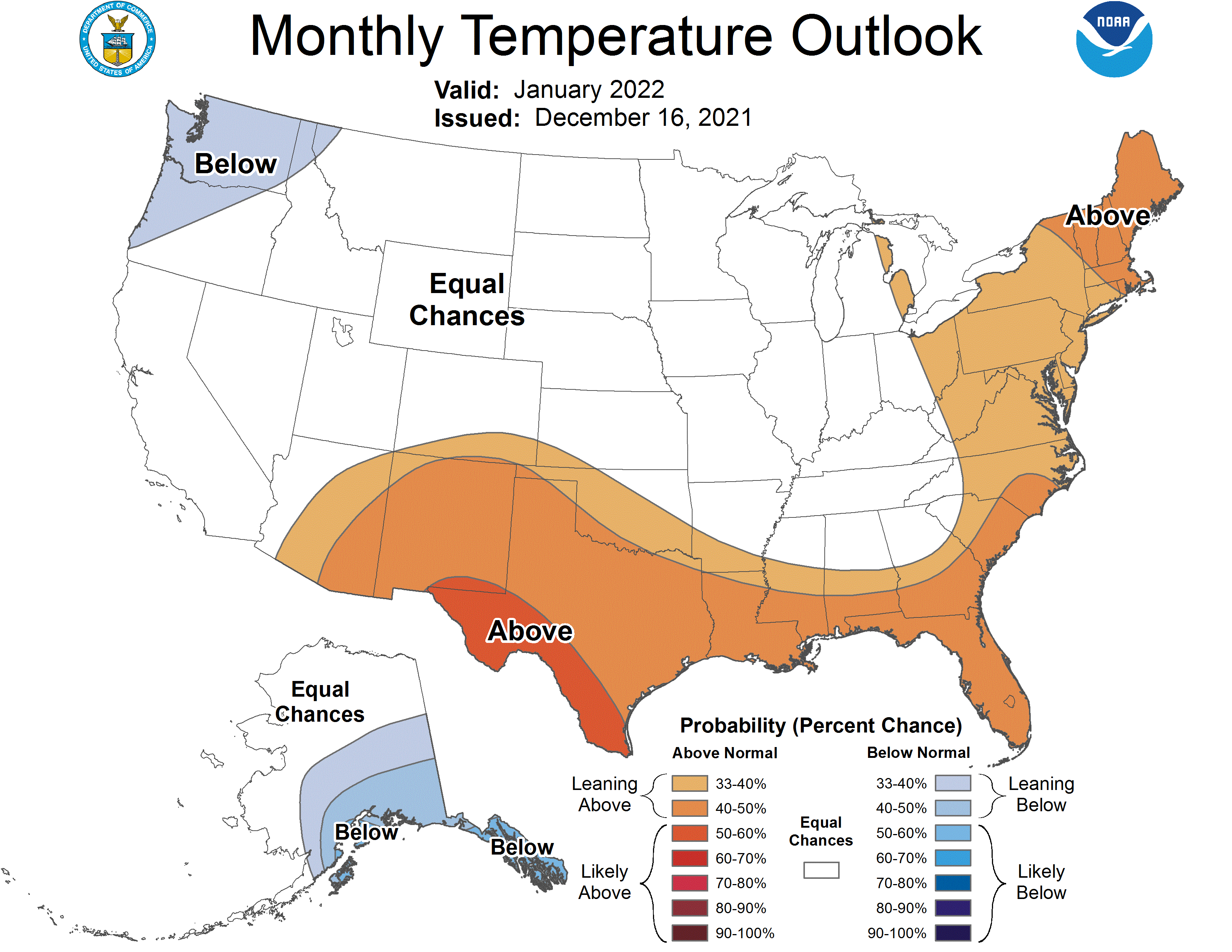
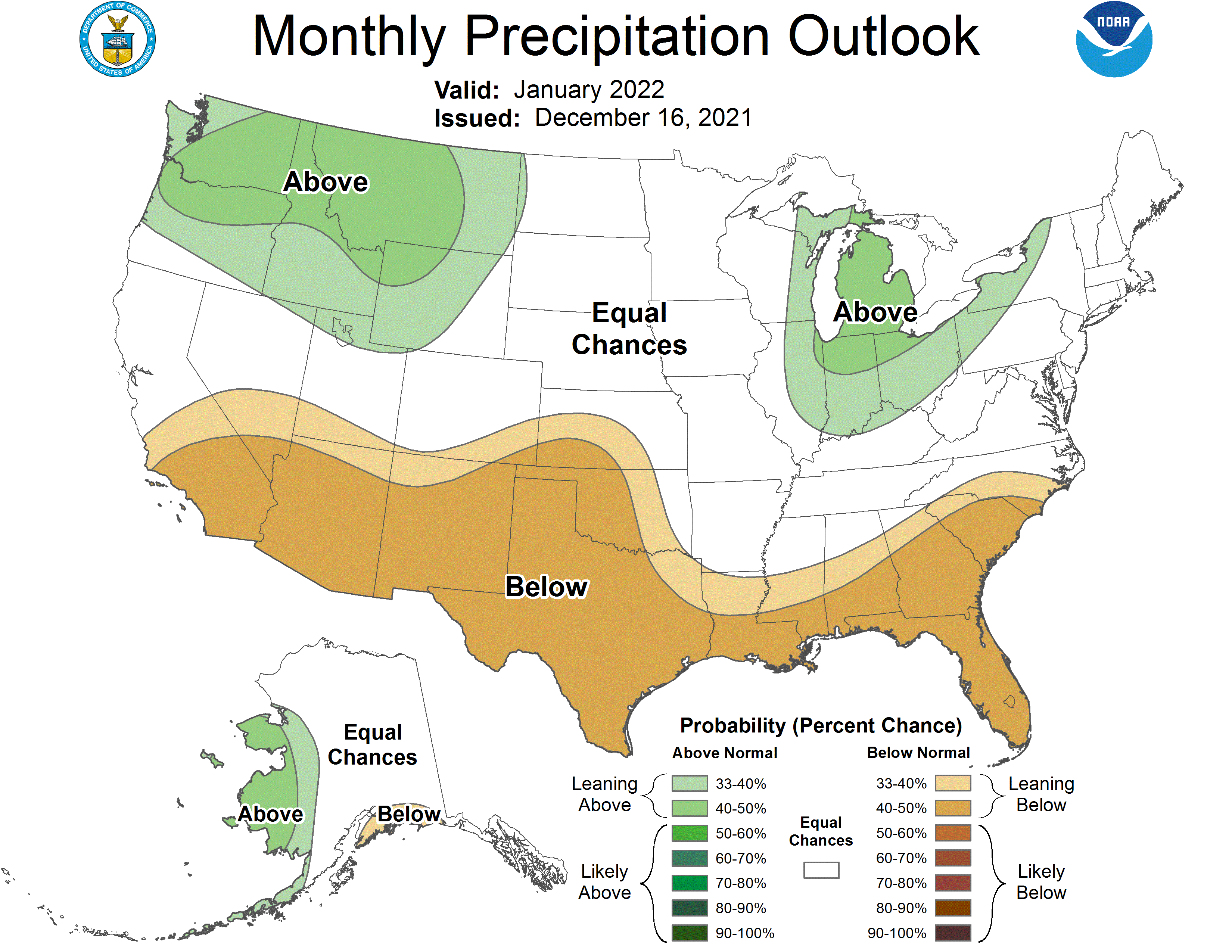
The CPC has their outlook for January out which is guessing near normal temps and above normal precipitation (which means snow at this time of year). There is a small change of above-normal temps in the thumb and northeastern Michigan. My concern is with the tightly wound storms we have seen over the past week coming through with wind-driven blizzards as we have colder conditions. This has been a memorable winter thus far and I am sure we will be in for some more surprises.
[columns] [span6]
[/span6][span6]
[/span6][/columns]
Forecast Discussion
-- Light Snow Saturday --

After a mostly sunny Friday with lighter winds and some high
clouds streaming through, clouds increase Friday night as a low
pressure system develops near the Ohio River valley. Moisture
mainly below 10,000 feet undergoing isentropic lift over southern
Michigan will produce light precip between the pre-daybreak hours
of Saturday and Saturday evening. The thermal profile is barely
cold enough to support snow and the DGZ unsaturated much of the
time, so this doesn`t look all that impressive. The amount of QPF
is not solidly nailed down from model to model but most solutions
yield a snowfall of about a half-inch to 2 inches mainly near I-94
and perhaps up to I-96. There remains some lower-probability
solutions (about 10 percent) of near zero QPF on the low end to
over 0.3 inch QPF on the high end.

As winds turn more from the north-northwest Saturday night, there
may be an opportunity for lake-effect snow near the lakeshore,
however the depth of moisture and convective instability is
questionable and this may subdue the potential prior to ridging
and high pressure becoming more established on Sunday.

-- Near normal temperatures into much of next week --

Ensembles are tightly clustered with the temperature forecast
through Monday night, then become increasingly spread out through
the rest of the week. It will be relatively uneventful for a few
days other than some breezy conditions on Monday and a chance of
light snow Tuesday night into Wednesday. The general pattern
across the continent will feature warmer-than-normal temperatures
to our south/southwest and colder-than-normal temperatures to our
north/northwest. As has been the case recently, this baroclinicity
often results in stronger jet streaks and high/low pressure
systems, and some temperature swings and precipitation chances are
entirely possible toward the end of the week. Can`t make a lot of
promises with the details yet.
Get ready for the snow tonight and tomorrow!
The winter solstice has not even arrived yet and our coldest and snowiest part of winter is the 6 or 7 weeks after this event! Get prepared for a wild ride!
Yeah we may be down to a 2 month winter (if that) again.
Mmmmhhmmmm….
Andy you didn’t need to post a picture of you golfing this past summer,
This December has been very similar to the past year or 2. A week from Christmas and the ground is bare, grass is green, temps are breaking records above average, and the snowfall deficit is once again big and growing by the day. Sunsets are getting later and soon almost a third of winter is over already.
December 17, 2021 The official overnight low at GRR so far is 28. Here at my house it is a colder 24 and with clear skies that is the current temperature here at my house. We are now just past the half way point for December 2021 and it has so far been a very mild month with well below average snow fall and a lot of wind. At Grand Rapids the current mean for this December is 36.5 that is a departure of +4.2. At Muskegon they have a mean of 38.9 and that is a departure of +5.3… Read more »
Great news>>>>>the teleconnectors are still trending towards cold and snow! The AO may tank by the end of the month! Get ready for winter! If you don’t have your snow blower ready yet you only have about another week or two to get prepared! Don’t say that I didn’t warn you! Get ready to rock and remember Rock n Roll will never die!
If it indeed gets cold in January then the lakes are still warmer than average so there could be some big time lake snow events.
Slim
Bring it on!