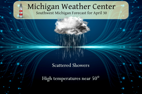
Good morning to all. Rain will be the theme today and will only go downhill from there. May will start off with cooler-than-normal temperatures and yes that nasty “s” word (snow) comes into play. We will recover back into more springlike temperatures by Thursday with sunny skies and highs in the mid to upper 60s!
Winter storm warnings are going up in the western U.P.:
...WINTER STORM WARNING IN EFFECT FROM 8 PM THIS EVENING TO 11 AM
EDT TUESDAY...

* WHAT...Heavy wet snow expected. Total snow accumulations of 6 to
  24 inches. The lowest snow accumulations will occur close to
  Lake Superior, and the greatest accumulations will occur in the
  area to the south and east of L`anse and to the west and
  northwest of Negaunee. Winds gusting as high as 45 mph late
  tonight through Monday evening.

* WHERE...Baraga and Marquette Counties.

* WHEN...From 8 PM this evening to 11 AM EDT Tuesday.

* IMPACTS...Travel could be very difficult to impossible. The
  hazardous conditions will impact the Monday morning and Monday
  evening commutes. With heavy wet snow collecting on trees and
  powerlines, the stronger winds late tonight through Monday
  evening will cause tree damage and power outages.
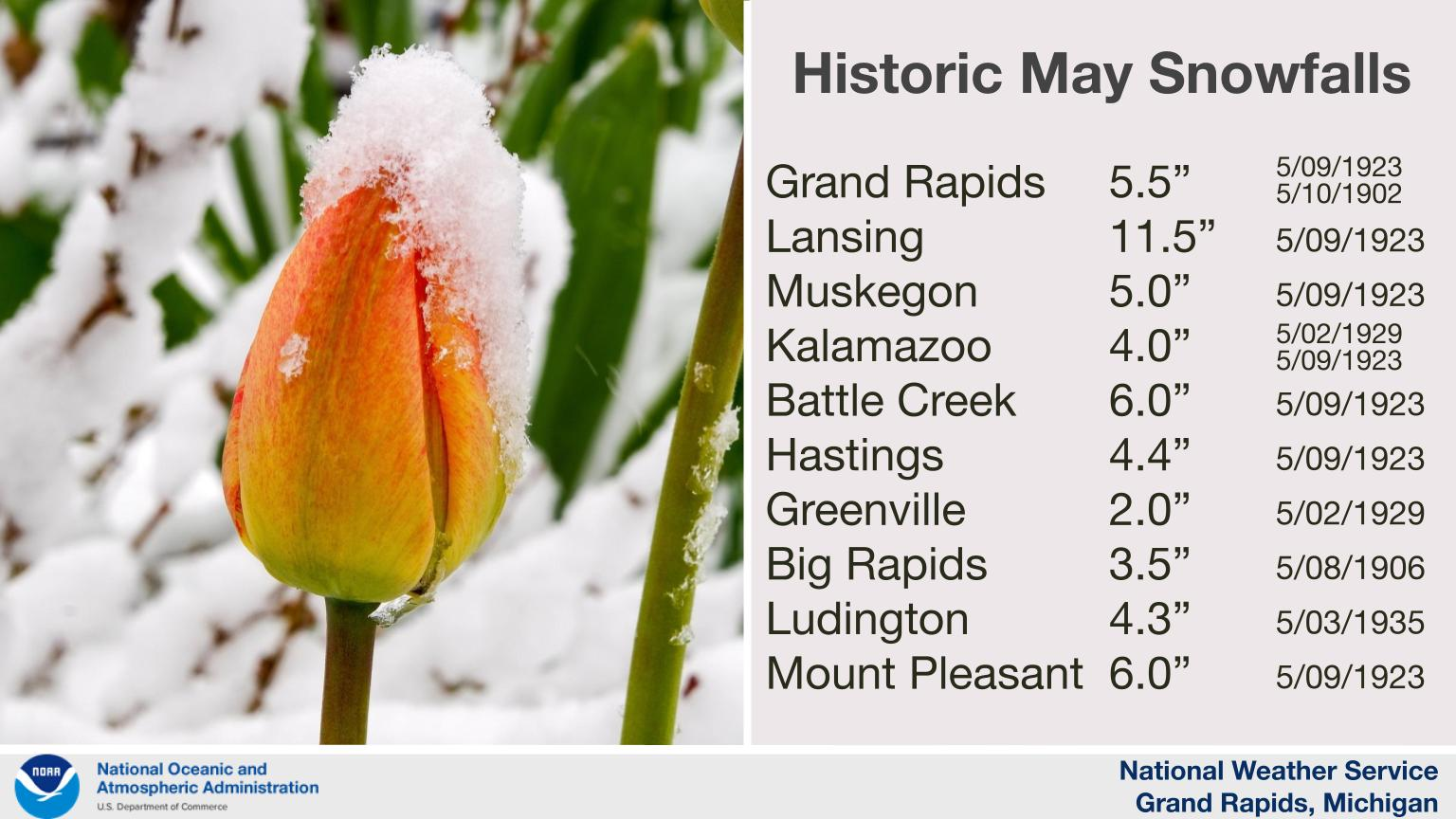
Accumulating snow in May is rare in this part of Michigan, but it does happen from time to time. This is a list of the greatest measured May snowfall in each city’s record books, going back about 120 years.
U.S.A and Global Events for April 30th:
1888: 246 people died in the world’s deadliest hailstorm in India. Hailstones were reportedly the size of baseballs. 1600 domesticated animals at Moradabad perished. Click HERE for more information from the History Channel.com.
1924: A significant tornado outbreak occurred from Alabama to Virginia on the 29 through the 30th. 26 tornadoes were of F2 intensity or greater. A total of 111 people were killed, and over 1,100 injured. An estimated F4 tornado tore through Steedman and Horrell Hill, SC. This tornado killed 55 people.
1953: An F4 tornado 300 yards in width leveled homes on the north side of Warner-Robins Georgia, and barracks on the south side of the Warner-Robins Air Force Base. 19 people were killed and were 300 injured. The estimated damage was $15 million.
Grand Rapids Forecast
430 grrForecast Discussion
- Unsettled Through Tuesday -

Following scattered showers and a few storms last evening,
conditions have dried out early this morning with even some clearing
across the area thanks to the post-frontal dry slot. Today the
broad surface low and it`s associated upper trough will become
cutoff and vertically stacked, therefore our brief dry conditions
will be short lived as a series of vorticity lobes pivot through
the region today through Tuesday.

Scattered to numerous showers will return late this morning and more
so into this afternoon. As the cold pool aloft also centers over the
region, mid-level lapse rates around 6-7 C/km will support some
rumbles of thunder and given the cold temps aloft, some graupel or
small hail is also within the realm of possibilities. This will be
even more likely further south and east where more effective surface
heating may occur ahead of the arrival of the upper low.

A secondary low originating from the Mid-Atlantic will traverse
northwards and become ingested into the main cyclonic pattern over
the Great Lakes region late tonight into Monday. As this occurs,
moisture will become enhanced through theta-e advection and wrap
around to the west side of the low. As the low very slowly pivots
into Lake Huron, this arm of moisture will slide west through the
state late tonight through early Tuesday. Precipitation is expected
to fluctuate between rain and snow at times through Tuesday, and
ensemble guidance supports the possibility of some areas seeing a
few inches of snow. The coldest air will arrive on Monday leading to
the greatest chances for snowfall centered around Monday and early
Tuesday. Warm ground temperatures are the obvious limiting factor on
actual snowfall accumulation as recent surface soil temps at GRR
read around 50 degrees. While most areas shouldn`t see major impacts
with accumulating snow beyond a brief not-lasting few tenths on
grassy surfaces, higher terrain areas may see actual slushy
accumulations Monday and early Tuesday. Highs will struggle to break
out of the 40 degree mark for most areas on Monday, especially
further north and at the notoriously cooler higher elevation
locations in the central interior portion of lower MI.

In addition to the possible accumulating snow Monday, winds will
increase Monday morning and peak during the afternoon and evening.
Northwest gusts to around 30-40 mph look likely for most areas, and
gusts near the lakeshore to 45 mph or higher look possible. Winds
will taper off slightly Tuesday, but conditons will still be breezy
through the first half of the day.

On Tuesday the upper low will finally drift far enough to the
east to release it`s grip on West Michigan. Any lingering
precipitation will taper off late Tuesday as subsidence settles in
on the backside of the departing low.

- Dry Wednesday, Rain Chances Late Thursday and Friday -

Quiet weather returns Wednesday as weak upper ridging moves in.
Precipitation chances will return late Thursday and Friday with
mainly just a few showers expected. A general warming trend is
expected starting Wednesday with highs hitting closer to seasonal
norms in the low 60s by Thursday.
Wow!
https://www.pivotalweather.com/model.php?p=snku_acc-imp&rh=2023043018&fh=120
Get ready – Snow is coming!
Summer outlook was updated on April 20th by the CPC. At this stage they say slight above average temps for the summer and slightly above average precipitation. We shall see how it plays out.
https://www.cpc.ncep.noaa.gov/products/predictions/long_range/seasonal.php?lead=2
May snow showers outside crazy this has been one of the longest winters in a while ….INDY
No doubt about that, with above normal snowfall in March and now a cold Spring with winter like temps in late April and early May! Incredible winter and cool Spring!
Great golf weather? Right? In your dreams! Forget golf till at least next week Thursday! Wow!
Get ready for cold, wind, rain and SNOW! What a start to May! The cold pattern continues! Wow just wow, WOW!
We went over to Windmill Island before the Tulip Time crowds. Was nice out yesterday, before the rain. I haven’t been to Holland in years. Used to go every summer to the fair, but they don’t have harness horse racing there anymore.
The forecasted high of 41 for Grand Rapids would be the 2nd coldest maximum for any May 1st and the forecasted high of 44 on Tuesday would be the 4th coldest maximum for any May 2nd There is also snow in the forecast and on both days since 1893 it snow has only been reported 4 years. So a very cold start to May. By next weekend temperatures look to warm up to near average. On Saturday the average H/L is 66.3/45.1
Slim
Yesterday was a mild day until the rain moved in. The official H/L was 64/40 there was .014” of rain and 37% of possible sunshine. The overnight low both at GRR and in MBY was 40. For today the Average H/L is 64/43 the record high of 87 was set in 1894 and 1942 the record low of 26 was set in 1971 and 2008. The record snow fall of 3.6” fell in 1963.
Slim