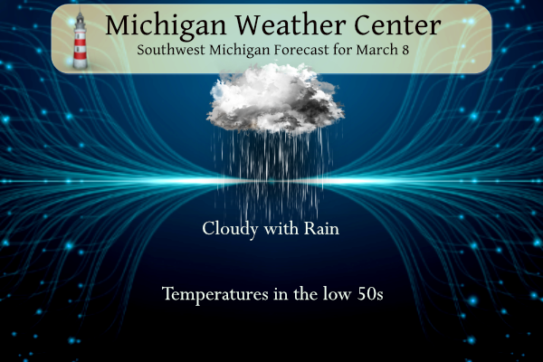
We have some rain moving in from the southwest this morning it will overspread the area lasting through tomorrow as it tapers off to scattered light showers and drizzle. Rainfall forecast totals could amount to over an inch.
NWS Forecast
Weather History
1943: Grand Rapids plummets to 13 below zero, the coldest ever recorded in March there. This caps a very cold period during the first ten days of the month, where four days had lows at or below zero at Grand Rapids.
2000: Temperatures soar into the upper 70s across Lower Michigan, with some places hitting 80 degrees. The 78 degrees at Grand Rapids is a record high for the date and for so early in the season.
2014: Severe and prolonged cold weather during the winter brought record ice coverage to Lake Michigan by early March. Ice coverage peaked at 93.29 percent on this date, just edging the record of 93.1 percent set in the winter of 1977.
2017: A powerful low-pressure center moving through southern Canada brings winds gusting over 60 mph across Lower Michigan for much of the day. Winds reach 64 mph at Grand Rapids. The winds cause millions of dollars in damage and large-scale power outages. Two people were killed when a tree fell on their vehicle while they were driving on M-115 in Clare County.
On March 8, 2018, a long-duration accumulating snow came to an end as a slow-moving storm moved through the region. When it was finally over, accumulations approached one foot in Huron, Lapeer, and Sanilac Counties. A peak measurement of 14″ was taken in Cass City in Tuscola County.
Also on March 8, 2017, ideal high wind conditions took shape under perfectly sunny skies. Strong winds developed early Wednesday morning and intensified steadily into the afternoon. Widespread wind gusts in excess of 60 mph were recorded, including 68 mph in Detroit and Saginaw and 61 mph in Flint. The power outage footprint grew steadily through the day eventually leaving approximately 1,160,000 customers statewide without power. Final estimates indicate approximately half a billion dollars in damage.
Also on March 8, 2000, the temperature rose to 80 degrees in Flint, a record for the date and a tie for the 5th warmest maximum temperature for the month of March in Flint.
1669: The 1669 eruption of Mount Etna is the largest-recorded historical eruption of the volcano on the east coast of Sicily, Italy. After several weeks of increasing seismic activity that damaged the town of Nicolosi and other settlements, an eruption fissure opened on the southeastern flank of Etna during the night of 10-11 March. Several more cracks became active on March 11, erupting pyroclastics and tephra that fell over Sicily and accumulated to form the Monti Rossi scoria cone.

1909: The town of Brinkley, Arkansas, was struck by an estimated F4 tornado, which killed 49 people. The tornado, which was two-thirds of a mile wide, destroyed 860 buildings. Entire families were killed as houses were completely swept away by the storm. The graphic below is from a tweet by the NWS Office in Little Rock, Arkansas.

1972: A wind gust of 207 mph was recorded on a Bendix-Friez Aerovane anemometer at Phase Shack #7, located six miles east of the Thule Air Force Base in Greenland. Winds were sustained at over 146 mph for three hours during the storm. Click HERE for more information from Weather Underground. Click HERE for more information from a website called 557 Weather Wing.

1989: While Arctic cold gripped the northeastern U.S., unseasonably warm weather prevailed across the southwestern states. Albany, New York, reported a record low of 2 degrees below zero. Tucson, Arizona, reported a record high of 90 degrees.
2000: An F1 tornado traveled a short distance across Milwaukee, Wisconsin, during the evening hours. The tornado injured 16 people.


2017: Malta’s famous Azure Window rock arch has collapsed into the sea after heavy storms. Click HERE for more information from BBC.
2018: A horseshoe cloud was seen over Battle Mountain, Nevada. Click HERE for pictures from the NWS Office in Elko, Nevada.
Forecast Discussion
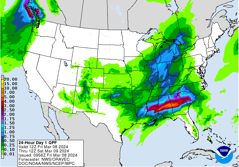
- Rain Today and Tonight

Increasing subtropical moisture associated with an approaching
surface wave ejecting out of the Southern Plains will influence
widespread rain showers this afternoon and tonight. Regional radar
shows a swath of widespread rain spreading northwards towards
southwest lower Michigan with low reflectivity signatures
beginning to creep into southern Berrien County. Rain should
continue to progress into the area through the morning hours and
showers will overtake the whole forecast area by mid-day to early
afternoon. Precpitatble water values push towards 1 inch this
evening as a 40- 50 knot LLJ noses into the southern half of the
state. Mid-level lapse rates increase this evening so a few
rumbles of thunder may occur. A good soaking rain is expected with
QPF of around 0.5" up near Mason County increasing to the
southeast towards 1.15" near Jackson / Ingham/ Calhoun Counties.
As the center of the surface low tracks northeast out of lower
Michigan the bulk of the moisture is drawn away with it. Much of
Saturday looks precip free, but if any precipitation does occur it
may be cold enough for snow to fall mainly north of Muskegon and
Grand Rapids.

- Lake effect snow chances remain for Saturday Night

Lake effect snow chances for Saturday night remain, at least in the
NAM. The GFS looks much more paltry. We do have some moisture,
albeit a bit less than last night, but there is solid moisture below
5,000 feet. A strong northern stream shortwave will be surging
through the area and we should have delta T`s in the lower to middle
teens C. So, the ingredients are there for some accumulating snow.
At this point there is potential for an inch or two of snow, but we
will be watching this time frame for trends in either direction.
Temperatures will be falling through the 20s Saturday night, so not
out of the question for a few slick spots.

- Moderating trend in temperatures next week

850mb temperatures will rebound from near -12C Saturday night to +8C
by Tuesday in the ECMWF. Warmer air at 850mb remains in place at
least into Thursday. So, high temperatures will rebound from the 30s
on Sunday into the lower 60s Tuesday, Wednesday and Thursday.

- Chances for rain mid next week

We continue to carry chance pops in the forecast from Tuesday night
through Thursday in the 20-50 percent range. There is a weak cold
front forecast to move through the area on Wednesday. A low follows
behind the Wednesday front for Thursday. Differences remain in the
handling of that system though so only low chances for rain in the
forecast at this point.
Who wouldn’t snow this time of year! Breaking news…it is still Winter! Rock n roll baby!
Only 11 days left of the worst season of the year! Luckily we’ve had beautiful spring like weather since the end of January and much more to come! Who would want cold and snow this time of year??
Who doesn’t understand that we still have a lot of cold and some snow still to come this Winter and Spring! Happens every year! Incredible!
Lots of 60’s and sunshine next week. Who doesn’t like early springs?!
Too bad this rain heading our way is not all Snow! Get ready for a cold, wet, windy weekend! Typical mid March weather! Forget about temps in the 70’s!
The horseshoe cloud is cool. Don’t think I’ve heard of a horseshoe cloud previously.
Almost looks like a staple cloud.
Slim
The official H/L yesterday was 48/31 there was no rainfall the highest wind gust was 25 MPH out of the SE. There was no sunshine. For today the average H/L is 41/25 the record high of 78 was set in 2000 the record low of -13 was set in 1943 the wettest was in 1942 with 1.02” of that 1.9” was snowfall. The most snow fall was 4.5” in 1931. Last year the H/L was 44.24
Slim