
Yesterday we had a high temp of 75° and a low of 64°. Our rainfall total for yesterday was .03 of an inch which brings our total for the month to 1.49 inches and our summer total to 10.49 inches. (These are Otsego measurements here at the station). Most of this spring/summer rainfall has fallen since June 18th.
Our temp at 5:30 am is 69° with a few rain showers around the area. Rain chances for lower Michigan will continue through the afternoon with a chance for a few embedded storms which could dump a lot of rain but most of the area should see a quarter to half-inch of rain.
SPC Forecast
[columns] [span6]
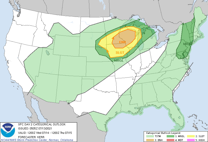
Day Two
[/span6][span6]
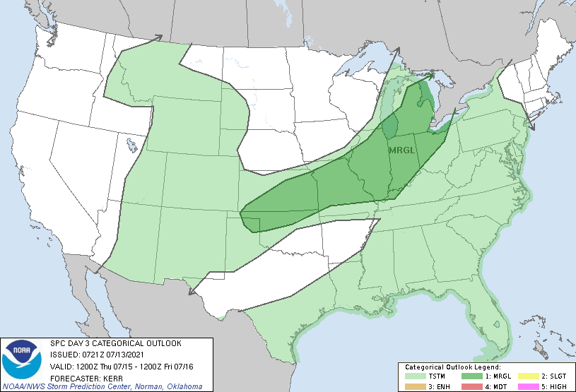
Day Three
[/span6][/columns]
Forecast Discussion
- Showers and embedded storms expected today

Finally, some better organized rainfall has made it over portions of
the area with the system that has been sitting to our SW over the
last couple of days. The upper system is currently transitioning
into an open wave to our west. The best rainfall early this morning
is over the NW portion of the area up toward Ludington.

Initially, we will be watching for some locally heavy rainfall
toward the Ludington area. There looks to be maybe some upper level
divergence forcing on the LFQ of an upper jet streak over Lower
Michigan. This rain may get stuck there for a few hours as the upper
low opens up, and then until the resulting open trough gets kicked
east today.

As the trough pushes through the area today, it will encounter a lot
of cloud cover. This cloud cover will limit the amount of
destabilization that can occur, and thus the potential of strong to
severe storms. Aside from any diurnal destabilization that is
limited, we do have elevated instability overhead, that will allow
for a few storms to be embedded in a line of showers ahead of the
sfc front and trough coming through. If some thin spots in the
clouds can develop ahead of this line, some stronger storms would be
possible. Otherwise, the very moist air mass will provide mainly a
locally heavy rain threat with precipitable water values around 1.75
inches.
.

Once the front and trough pushes through later this afternoon, we
should see a break in the rain chances.

- Showers and storms Late Wednesday night into Thursday night

Our next feature to watch will be a potential of a line of storms
that could approach the area Wednesday night into Thursday morning.
The last few days, the models are in decent agreement showing that
the sfc low, and associated low level jet will affect Northern Lower
and Upper Michigan more directly.

What we can expect to see in our area will be a dying line of
showers and storms at the tail end of the northern MCS dropping into
the NW counties toward daybreak Thursday morning. It will likely
eventually completely die out, leaving an outflow boundary to sink
through a portion of the area.

Where this boundary ends up will play an important factor where
additional storms development would take place, along with a severe
threat. Areas south of the outflow boundary will have a chance to
heat up a bit into Thursday afternoon. This would allow CAPE values
to climb to 2,000+. The front/outflow boundary moving into this air
mass would likely help fire convection that would have the potential
for some strong to severe storms. The likely area looks to be
roughly south of a South Haven to St. Johns line. Deep layer shear
values in the 30s would help to organize the storms.

- Quieter weather expected for the coming weekend

A bit of uncertainty has cropped up regarding the exit of the front
and associated rain for Thursday night and Friday. The models had
been showing the front clearing the area, and leaving us cooler and
dry. Now, there is growing support that the front may hang up closer
to the area, and allow a wave to move along it and keep rain chances
in across the southern half of the area on Friday. The driving force
with the position of the front seems to be the trough that was going
to push through, slowing down and possibly hanging over the area a
bit longer.

Eventually it should push far enough south to get us into drier air.
The question is just when does it do that. We will watch the trends
over the next couple of days to fine tune this part of the forecast.
Nice little bow echo overhead now. Some lightning but raining hard sideways. I’m guessing 30-35 mph. Temp has dropped to 79.
Just had another very heavy shower come thru here. No thunder here at all today but now up to 0.52″ of rain so far today.
Slim
72 and very humid when I woke this morning. Glad I had the house closed up with the a/c on. Sunny and 81 now, but not for long. More thunder moving in.
Getting a moderate shower at this time. With that rain it is now just 70.
Slim
It’s been more tolerable lately than the day after day with the heat index in the mid ‘90’s to 100, but still very humid out yet. Dew point is up to 71 this morning. Very thick air.
8 of the first 12 days of July 2021 have been below average temperature wise. There now have been 5 days in a row when it has not reached 80 if it fails to reach 80 today that will make 6 days in a row and you have to go back to July of 2013 to find a string of such days in July. I recorded 0.03″ of rain fall here yesterday and overnight. Officially there was only 1% of possible sun shine yesterday so in what should be our sunniest time of the year we year instead we are… Read more »
Slim sofar only one recorded 90* degree day in my area and now it’s mid July should I say I love short Summers lol …INDY
Incredible!
Cloudy sky’s temps in the 70’s again today midddle of July now and the days are getting shorter September is coming fast with a quiet Blog lately woo wooo I wll say!! Sofar our Summer has been easy-going on the heat who would if thought??. INDY
No heat waves and below normal temps! I love it!