
After scattered showers the first half of yesterday the late afternoon turned out to be fairly pleasant. We picked up .20 of an inch of rain yesterday bringing our total for the month to 1.69 inches. We have expectations of another nice dry day before the threat of storms moves into the area overnight into Thursday. Below is the day one and two outlooks from the SPC – we remain in the marginal area for severe weather. The only concern is the ominous area of enhanced chances of severe weather to our west making it across the lake into the western counties (see Forecast Discussion)
[columns] [span6]
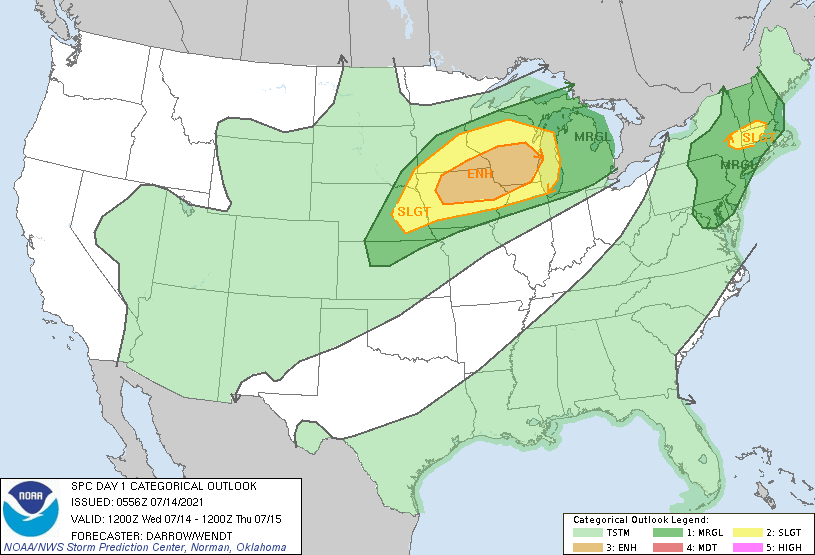
Day One
[/span6][span6]
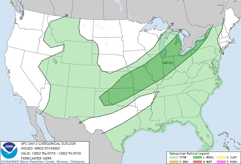
Day Two
[/span6][/columns]
Forecast Discussion
- Chances of strong/severe storms into Thursday night

After the somewhat active day on Tuesday with convection, most of
today will be relatively quiet before things become potentially
active tonight through Thursday night.

The majority of the daylight hours today will be dry, although there
is a small chance of a sprinkle/light shower this morning along the
southern border. This is the result of a weak short wave riding
along the MI/IN border acting on limited moisture. Once the short
wave moves through, the afternoon should be dry.

Our attention then turns to the potential of a line of showers and
storms that could approach the area as early as mid-Wednesday
evening. This chance will be driven by a wave/MCV that is currently
across SD with convection across Srn SD and Nrn NE. This convection
is forecast to continue east, and will likely pick up in intensity
this afternoon with peak heating near the border of MN/WI/IL.

The trend of this complex is a bit uncertain yet with variations of
solutions by the CAMs and synoptic models. We can not argue that a
line of showers and storms will bring at least a chance of rain this
evening for the western counties. There does seem to be decent
agreement that if the line does approach the area, that is will be
running out of steam as the best instability will stay to our west.
That said, if it has enough momentum and can survive the cooler
lake, an isolated area of wind damage could not be ruled out.

As the afternoon/evening line is expected to run out of steam, the
models have been fairly consistent in showing development/
intensification of storms across Nrn WI, and eventually Nrn Lower
and the U.P.. This is a fairly good signal as this convection would
be driven by a sfc low and associated low level jet of around 50
knots. We expect that we would see the far southern flank of that
line clip our NW counties overnight into Thursday morning.

This feature also will have implications for the severe potential
for Thursday afternoon. There will likely be an outflow boundary
from the Nrn storms that would try to sink south through the area.
Depending on where that ends up, areas south of it would have a
chance to destabilize, and see severe storms develop Thursday
afternoon. Deep layer shear is not ideal with 25-30 knots available
where convection might develop. Again, this is all contingent on
where the outflow boundary from Thu morning ends up.

- Rain chances linger into the weekend especially South

The trend for the past couple of days has been for a slower exit to
the front, and a little more wet over the southern portions of the
area. This is a result of a short wave that gets hung up a little
more near/over the area. This will allow impulses in the flow to
ride along the front and produce additional chances of rain. The
timing of these impulses is a bit problematic, so we have rain
chances lingering over the south from Friday through the weekend.

- Generally drier pattern early next week

It does seem like the upper ridge over the Western U.S. will fold
over and provide enough of a push southward to the weekend trough to
get it out of the area. This will set up ridging over the area for
Mon and Tue allowing for more dry conditions. Temperatures will heat
up a bit after somewhat cooler conditions over the weekend.
Weather History for SW Michigan
July 11
1945: Muskegon falls to 40 degrees, setting a record low for the date. This is also the second coldest temperature for the month of July at Muskegon, just a degree warmer than the 39 degrees on July 2, 2001.
1957: Thunderstorms struck West Michigan with heavy rain and high winds. There was widespread flooding of streets, with some road washouts. The 3.19 inches of rain at Lansing made this the wettest July day of the 20th century there. Many trees were blown over by thunderstorm winds and lightning struck a TV antenna in Grand Rapids, burning out the transmission line.
1967: A tornado damaged a trailer, garage and silo about two miles west of Ferry in Oceana County.
July 12
1966: A tornado destroyed a barn at Coopersville in Ottawa County.
1978: Cool weather prevails with low temperatures in the 40s. Muskegon falls to 45 degrees, for a record low for the date.
July 13
1912: A tornado strikes downtown Grand Rapids at 4:10 AM. Several buildings are damaged and nine people are injured.
1936: The Dust Bowl summer of 1936 produces the hottest day on record across the state of Michigan. Grand Rapids hits 108 degrees, its highest temperature ever, with Mio, Michigan setting the state record of 112 degrees. At Grand Rapids, six out of the seven days from July 8th to July 14th were above 100 degrees.
1964: Clouds, rain and a cool northeast wind holds the high temperatures in the upper 50s to mid-60s across West Michigan. The high of 59 degrees at Grand Rapids is only the second time in over a hundred years of record that the temperature did not reach 60 degrees on a July day.
July 14
1950: Cold air filters into Michigan, setting records lows of 45 degrees at Grand Rapids and 41 degrees at Muskegon.
1974: Several tornadoes struck Lower Michigan during the afternoon, causing some structural damage but no injuries. In Mecosta County, a house and some farm buildings were damaged about four miles east of Sylvester. Apartment buildings were damaged near Plymouth, in Wayne County. Seven houses were destroyed and 50 damaged near Davison in Genesee County.
1995: An intense three-day heatwave claims hundreds of lives across the Midwest, mostly elderly people in the greater Chicago area. The low temperature of 81 degrees at Grand Rapids on this day is the warmest low temperature ever recorded there. Temperatures in the upper 90s in the afternoon combined with high humidity to produce heat index readings near 120 degrees, some of the highest ever recorded.
July 15
1863: It was a frosty morning with temperatures falling to the 30s across much of Michigan. The low of 31 degrees is the coldest ever recorded in July at Lansing by a full five degrees.
1961: A heavy downpour hits Grand Rapids, with 0.41 inches of rain falling in 15 minutes.
1985: A tornado touched down in the northeast section of Lansing and damaged 18 buildings as it moved to three miles north of Webberville in Ingham County.
1987: It was the coolest July day on record at Grand Rapids, with a high of only 58 degrees. Clouds and rain kept temperatures in the upper 50s and lower 60s during the day after morning lows in the mid-40s.
July 16
1945: The second morning of record cool weather in five days produces low temperatures of 42 degrees at Grand Rapids and Muskegon.
1986: A plane carrying executives from Holland to Muskegon crashed while landing in heavy fog. The pilot had descended below approach minimums and the plane struck two trees about two miles short of the runway. Three people were killed, including the pilot. Three others were injured.
July 17
2006: A widespread severe weather outbreak struck West Michigan. Dozens of trees were downed by winds gusting between 60 and 70 mph. A camper was injured by a falling tree at a campground in Dorr, Allegan County. Two-inch diameter hail fell at Marne in Ottawa County.
2009: The high of 67 degrees at Grand Rapids is a record cool high temperature for the date, and contributes to July 2009 becoming the coolest July on record. The highest temperature for the entire month is only 84 degrees, the lowest monthly maximum temperature for any July on record.
1994: A small, short-lived tornado was observed lifting small debris at the Clare County airport north of Harrison.
Weather History for SE Michigan
July 11
On July 11, 1964, Genesee county experienced 1.75-inch hail and winds up to 58 mph around 5:50 pm.
July 12
On July 12, 1966, Detroit had a record amount of precipitation fall in 24 hours. They received 3.19 inches!
July 13
On July 13, 1936, the temperature soared to 111 degrees in Saginaw, which is all-time record high temperature ever recorded in either Saginaw, Detroit, or Flint! This day also marked the sixth day in a row (July 8-13) of daily record high temperatures in Saginaw!
On July 13, 1995, The “right turn derecho” plowed south-southeast down across East and Southeast Lower Michigan on its way toward Ohio.
July 14
On July 14, 2000, parts of the north and west suburbs of Detroit received golf to tennis ball size hail with a severe storm that pushed through.
Also on July 14, 1992, Detroit had a high temperature of 83 degrees. This is about the average high temperature for mid-July, but it was the warmest day in Detroit in July of 1992, the second coldest July on record and part of the “Cold Summer of 1992”
July 15
On July 15, 2010, severe thunderstorms moved through most of Southeast Michigan. There were 32 severe weather reports included a measured 71 mph wind gust near Davison and wind damage consistent with winds up to 80 mph in Flushing. Most of the reports were wind gust and associated wind damage, but there were a few isolated large hail reports.
Also on July 15, 1988, would mark the last day of a 23-day dry spell in Southeast Lower Michigan. There was a total of only 0.04 inches of rainfall during those 23 days.
July 16
On July 16, 1980, between the hours of 8:30 AM and 9:30 AM, a powerful derecho swept through Southeast Lower Michigan. Winds were estimated to be up to 100 mph in Washtenaw county and up to 150 mph in Wayne county. Several observers remarked about the horrid dark green color the sky took on as the squall moved overhead. This storm blew out windows in the Renaissance Center. There was only one reported injury, and it was caused by the wind forcing a woman into a revolving door!
July 17
On July 17, 2012, the afternoon high temperature soared to 102 degrees, reaching 100+ degrees in Detroit for the third time that month. Highs also reached 101 in Flint and 100 degrees in Saginaw. All either tied or broke the existing record for the date.
On July 17, 1931, the temperature reached a record high of 100 degrees in Saginaw. Saginaw also had record highs of 98 degrees on the 15th and 16th.
Also on July 17, 2006, a squall line moved across Southeast Michigan hitting the Tri-Cities and Thumb regions the hardest. Severe weather was reported in all seventeen counties of Southeast Lower Michigan. Most of the damage was from severe winds, but there were a few reports of hail up to golf ball size in Saginaw. Winds were estimated up to 100 mph in eastern Huron County as hundreds of trees were snapped or uprooted. One person died, and one person was injured from lightning in Detroit.
Everybody around here is watching Saturday’s weather, as there are a few Grad Parties ready to go…
Another detailed, well-written forecast discussion from Bill Marino:
https://forecast.weather.gov/product.php?site=GRR&issuedby=GRR&product=AFD&format=CI&version=1&glossary=1
With the rain/storms to the west expected to weaken as they move east it looks like the Grand Rapids area should miss yet another chance of thunderstorms today and tonight. Later tonight it looks like most of the storms will be to the north and tomorrow to the south east. So bottom line there may be rain but still no major storms for GR. At this time there is hazy sun and 84 here and the DP has dropped down to 65 here.
Slim
Just got back from a nice walk. Yes it is warm and somewhat humid out. At this time it is mostly sunny and 82 here with a DP of 72. There are a few clouds popping up will see how that plays out. While there have been storms to the south and east of here right at my house I still have not had a thunderstorm (or at least what I would call a thunderstorms) yet this year. Yes there have been a few times when some thunder but mostly off in the distance.
Slim
We currently have a temp of 79 with a 72 dewpoint – phew!!
In the above weather history on July 14, 1995 at Grand Rapids that overnight low was between hours the lowest hourly report for that day was 82. The high for the date was 97. But get this the average Dew point for the day was 78.3 the highest dew point for the day was 80 and the lowest was 74. At 1PM the temperature was 94 and the Dew Point was 80 and at 4PM the temperature was 96 and the Dew Point was 78.
Slim
Wow to the wow another day in the 70’s coming up? Bring it onnnnnn!!! Possiblity of strong to severe storms overnight we will see what Lake Michigan thinks about that ….Have a super mid July day …..INDY
Not even close. WOOD has 85 today. Warm day!
07/14/95: WOW
At Lansing that day the dew point started out lower than at GR with a DP of 66 but there too the DP reached 80 and at 3 PM the temperature was 95 with that 80° DP. That was one very hot day.
Slim
Back to hotter weather after a nice little cool down. After a warm fall, a warm winter, a warm spring, and a warm June, it looks like July may finish warmer than average as well.
I recorded 0.52″ of rain fall yesterday. Officially GRR reported 0.68″ Yesterday was the 6th day in a row of highs at Grand Rapids in the 70’s The overnight low both here at my house and officially at GRR was 62 at this time it is 72 here with clear skies.
Slim