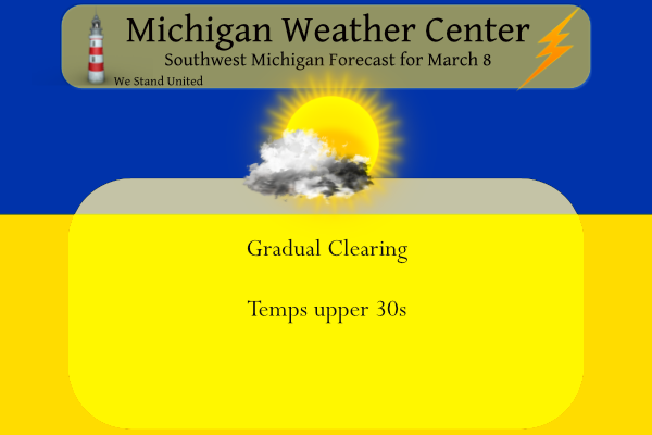
Not much to talk about weather-wise today as far as snow or storms go. Our spring transition continues. March can have a little of everything so we enjoy our quiet days as we can get them. Yesterday our high was 36° and the low 31°. We had .9 of an inch of wet snow which brings us to 55. 3 inches of snow, 16 inches more than last winter.
Our next chance of notable precip comes Thursday night from a synoptic event with other chances through the weekend. I am not one to get excited about forecast maps until a day before the event so let us wait and see how this plays out.
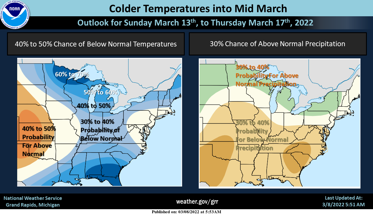
The 6 to 10 day outlook shows cooler temperatures with near to above normal precipitation should be expected this coming weekend into the middle of next week. We are currently forecasting possible snow showers on Saturday with highs in the 20s. A slow warming trend then follows but overall cooler and wetter (snowy) weather should be expected.
Forecast Discussion
- Small chance of snow showers North on Wednesday

After a busy couple of days with thunder, wind, and snow, we will
have a nice and quiet day today. There remains some residual light
lake effect early this morning as a short wave is getting ready to
exit the area. This will end over the next few hours, and skies will
clear out quite a bit. There is another short wave forecast to move
through later today. However, this one will not have any moisture to
work with. The over-lake instability also becomes insufficient as
temps aloft warm a little.

We have added a small chance of a few snow showers across Central
Lower for Wednesday. We have been expecting a weak and moisture
starved cold front to pass through the region. We just have not had
any pcpn chances with this feature until now. There is now some
short wave energy that will help the cause, and the temps aloft just
behind the front will be just sufficient to bring the potential of a
few snow showers across Central Lower. Any snow will be light with
little to no accumulation expected at this time.

- Accumulating snow looking more likely Thursday night

We have been watching a couple of opportunities for a synoptic snow
for the area from the Thursday night-Saturday time frame. It appears
that some of the details are starting to emerge just how this
scenario will play out.

The weak front that comes through on Wed is expected to stall out
just south of the area Wed night and Thu. A fairly formidable short
wave will dive in from the NW with a digging long wave trough, and
help to bring a wave of pcpn along the front. There is decent
agreement that this will come in from the SW through the heart of
the forecast area Thu night.

This pcpn should be mainly in the form of snow as the atmosphere is
sufficiently cold. Some pcpn on the southern flank could maybe be a
little liquid if just enough warmer air hangs in down there. This
does not look like big accumulating event as the moisture is a bit
limited. It does look like there will be up to a few inches of snow
possible with this, with the exact track still to be determined.

It looks like the chances of any kind of heavier accumulating snow
that looked possible are diminishing for Fri-Sat. The models are in
good agreement in bringing additional short wave energy along the
front, ahead of the long wave trough. The difference however, is
that the front is pushed further SE, and the better storm
development and pcpn will end up being SE of MI.

- Colder with multiple snow chances next weekend

What we do see now with the storm being further SE, is that colder
air is able to make it in earlier. We will see a NW flow aloft set
up over the area. This will initially allow for some lake effect as
850 mb temps drop into the upper teens C, allowing for plenty of
over-lake instability. Then, we will see another short wave come in
from the NW, and bring some snow to most areas on Sun. Another may
come in on Mon, but the cold air will have migrated further north,
and the system will tap much warmer air as 850 mb temps are expected
to warm into the + single digits C.
Interesting….
https://www.mlive.com/weather/2022/03/this-coming-week-brings-strongest-warming-rate-of-year-history-shows.html
Interesting find! Of course now you’ll prob be called a warm nut or whatever they’re calling it now.
Well it is just about mid March low 30’s are cold for this time of year ….InDY
The teleconnectors are all in place for use to get pummeled with Spring Time Warmth!!! BRING IT!!
Wow, the CPC sure flipped to warmth quickly! Just as predicted!
Exactly, never listen the the cold weather hype, fake news!
Speaking of fake news – you are the King of fake and false news!
Uhhh…..Bye Bye Winter!! Good Riddance!! LET THE WARMTH IN!!

You have clearly lost your mind!
Sorry you can’t handle the facts!
Lol
Get ready for another very cold weekend with chances of snow! Winter just keeps rocking! Wow!
As temps warm and winter continues dying, it’s time to look towards summer. How do we see summer 2022 playing out?
Gonna be an excellent summer, I’m predicting 37 total 90 degrees and we get pummeled with sun and thunderstorms!
Sounds great!
Looks like the cold weather crazies are saying we will get snow until July like they do every year and we’ll be seeing 100 inches of snow every winter, but they are wrong every year!! Give me a break!!
They have been totally wrong in their winter snow predictions so far!
It’s the same thing every year! The pivotalweather models that show us getting 24 inches of snowfall every week from November to April are great comedy gold all winter! So by those models we should be sitting on around 500 inches of snow right now!!
How many times to I need to explain how the models work! Every year! The models simply give you the expected and possible trend! These are not my or anyone else’s snowfall predictions! Keep it straight and get with it!
LOL Your personal posts and views from October and November say something very different to what you just said.
You are delusional!
I’m happy with the nice short 7 or 8
Week winter we’ve had!! Time for the nice long Spring!!
Lol, it has been a great winter for cold, snow, outdoor winter sports, etc! Incredible!
Looks like Sunday is another of many days the warm weather nuts are looking to as the start of a nice warm Spring! How wrong can they be? We have heard this multiple times over the last few weeks and every time they are wrong! They will be wrong again! We will be seeing more accumulating snow this month and plenty of cold windy days!
Here is a update on the seasonal snow fall at several major locations around Michigan. Grand Rapids 67.1″ Lansing 52.1″ Muskegon 50.8″ Detroit 39.6″ Saginaw 34.1″ Flint 53.1″ Alpena 59.8″ the Sault 127.0″ Marquette 175.1″ All locations seen more snow this winter season than last winter season. Detroit, Flint, Lansing, The Sault and Marquette are above average for the season so far. The other locations are below average for the date so far. Grand Rapids could still reach average for the season (but it is getting late) The biggest deficient is at Muskegon. Marquette, The Sault and Alpena still could… Read more »
FYI Slim, I think the GR total is a bit low? Maybe 57.1 or 67.1?
Thanks Nathan I fixed it. The correct amount is 67.1″
Slim
Slim – what was Lansing’s total for last season?
Last season Lansing total was 45.6″ 24.7″ of that fell in February this season 27.1″ fell in February. Last season at Grand Rapids 46.1″ fell that was the lowest for a season at GR since 1982/83. At Muskegon last season had 41.8″ The record at Muskegon is spotty but that is also was the least since 35.5″ in 1982/83 It should be noted that Lansing snow fall totals are also very spotty with a lot of missing data.
Slim
Thank you, sir.
Looks like Sunday is when we make a fantastic transition to SPRING TIME!! So the Cold weather crazies have a few days left to wet their pants about temps in the 30’s and some snow flurries here and there, but better weather is on the way!
https://weather.com/weather/tenday/l/b4ea0280869baa46799dc75eacef8904785ec43ad2f6fb098355fbc208a55e2c
Wow look at all those 50’s!
I sure hope that is right… anything over a week out I take with a grain of salt, but having consistent 50s would be great. I can finally start biking again 😀
That’s right Nathan, we are all looking forward to getting out and enjoying some fantastic warm weather again!! We are finally getting out of the worst season of them all!
I’m ready for 7 months of continual warmth!
So you will not be complaining on how “hot” it is all summer long this year? Glad to hear that.
Slim
I never complain about the heat! Bring on the 90’s!
LOL! We have been hearing this for months, while the cold and snow just keeps cranking! What a winter!
Officially there was 2.4″ of snow fall at Grand Rapids yesterday. That will go down as the 7th largest snow fall for any March 7th. The official high yesterday at GRR was 35 the overnight low here was 28. The official overnight low at GRR was 29. At the current time it is cloudy here and 33 there is still 1″ of snow on the ground.
Slim
Still below average snowfall for March and below average snowfall on the season. I love it!
(And that’s if you count all of yesterday’s snowfall that quickly melted down to an inch or less)
Is there anything better than a mid March snow map like this? That is a ton of cold and snow for mid to late March over the entire country! Truly incredible!
https://www.pivotalweather.com/model.php?p=snku_acc&fh=384
Holy cow, it’s going to snow in Dallas? 🙂
It just goes to show you how cold March is going to be!
That’s why those models are a joke!! It probably shows a foot of snow in the Bahamas next week!
Is there anything better than a little snow in spring? Half of it melts on contact. And then the little left over melts in the sun. No annoyances on the road and zero to shovel!
So far March is playing out exactly as predicted. A very warm first 7 days, a little mid March cool down, and then back to warmer temps.
Wow, That sure was a big March snowstorm! Basically non stop snow for almost 24 hours with most areas picking up 2 to 4 inches of snow! We are now up to nearly 70 inches of snow and much more to come this month! What a winter, yet the warm weather nuts never even admit when we have a storm! Total denial!