We have some light snow falling in Otsego at 5:30 this morning with a temp of 32°. Yesterday’s high was 61° at midnight and the low was 32°, rainfall was .13 of an inch.
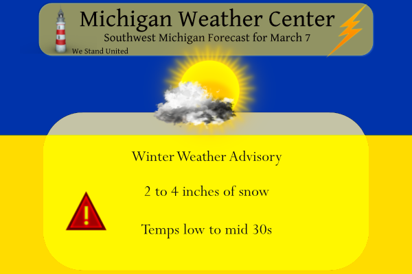
We have a winter weather advisory in place for the following counties:
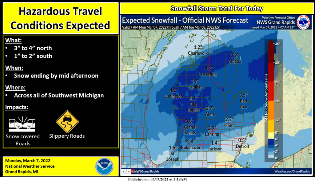
Mason-Lake-Osceola-Clare-Oceana-Newaygo-Mecosta-Isabella-Muskegon-Montcalm-Gratiot-Ottawa-Kent-Ionia-Clinton until 3 pm. Midland-Bay-Huron-Saginaw-Tuscola-Sanilac-Shiawassee-Genesee & Lapeer counties until 4 pm. These areas could see 2 to 6 inches of snow.
Areas south of a line between Holland and Lansing should see a mix of light snow, drizzle, and sleet with snow accumulations between 1 and 2 inches possible. This should move out of the area by mid to late afternoon.

Snow will continue into early to midafternoon before ending across the area today. Near I-94 there will be rain, and sleet, possibly some freezing rain into mid-morning before that changes to snow. Roads may be icy and snow-covered during periods of heavier snowfall. The heaviest snowfall rates are expected from late morning until around noon.
Forecast Discussion
- No changes to the Winter Weather Advisory this morning

Precipitation is coming in quickly on schedule this morning across
the area. The precip did start out at a few sites down south as
light rain initially. Those same sites have then changed over to
some UP or eventually light snow. This is because the air aloft is a
tad above melting, but then cools a bit through evaporative
cooling with the pcpn falling through the drier air.

We expect that the counties in the Advisory should see the bulk of
their pcpn fall as snow through this event. Further south along I-
94, there have been some fairly consistent signals that there will
be a mix of pcpn types for a bit before going to snow. This is due
to a slight melting layer aloft for a few hours. If this indeed does
happen, this will cut into snow totals a bit, which is what we are
expecting. Forecast soundings indicate that the main pcpn type other
than snow would be sleet.

If we were to expand the advisory, it would be for Allegan and Barry
counties, as they would have a better chance for all pcpn to be
snow, and for them to see similar totals as up north. We are not
confident in that yet. For us to issue an advisory across the far
south, we would need to see no mixture of pcpn types to allow snow
to add up, or to see freezing rain that would accumulate and cause
impacts.

The widespread snow is expected to taper off later this afternoon.
The snow will not totally end at that time, as we will see a few
snow showers hang on with a secondary short wave that will pass
through overnight tonight. Also, there will be just enough over-lake
instability and sufficient inversion heights and a dgz to support
some light snow showers. These will end overnight with the passage
of the trough and milder air aloft moving in.

- Quiet and mild weather Tuesday through Thursday

We should stay mainly dry from Tuesday, right on through Thursday.
The big picture pattern is not all that quiet, with plenty of
systems around. It just so happens though that the systems will stay
away from us during this period. There is a weak cold front that
drops down from the North on Wednesday, but it will not have any
moisture/pcpn with it.

- Potential for an impactful system next Friday/Saturday

We continue to watch for the potential of an impactful system out
toward the Friday/Saturday time frame. We will see another long wave
trough be carved out across the Plains later in the week. Out ahead
of this, a frontal zone will strengthen a bit and eventually become
active as weaker short waves eject out of the larger trough. It is
these short waves that will ride along the front, eventually tap
Gulf moisture, and produce pcpn.

It does look like there will be an axis of heavier snow amounts
somewhere just north of the boundary where the moisture and
sufficiently cold air are able to overlap. The uncertainty exists
with where this boundary was to set up. There are a lot of players
that have to come together for this system to determine where the
heavy snow may be. Being almost 5 days out, that is nearly
impossible to pin down at this time.

I was down in the Covert/Hartford area this afternoon and it was all snow early in the day. Then the sun would come out and snow mixed with ice pelletswould come down. Then the sun came out again then it snowed/ice pellets again. It repeated over and over again. Very interesting day.
Above average snowfall for March and below normal in temperatures…Just the facts …InDY
Guess what? There is more accumulating snow in the forecast this week and beyond! Winter is still cranking full speed ahead, despite the warm weather fantasies! Incredible!
Where’s the snow? LOL I’m officially not counting that for season totals haha
There is still snow on the ground here. The snow that fell today WILL be counted in the seasonal totals. That has been always been the case.
Slim
Mookies idea of snow counting is count the actual accumulation then divide by 4 and subtract 2! Always in a state of denial! That was a great March snowstorm!
Best kind of snow to get. Couple inches then all melted away by late afternoon. Fields are bare and snowless again. So much excitement over nothing.
There is still snow on the ground here. I expect it to be gone tomorrow.
Slim
Lol this was a great March snowstorm! Face the facts!
Yes, facts are it melted.
3.5 inches in my hood ….the snow that dosent stop isnt April next ?? Lol…Indy
Sun came out and melted most of what little snow (<1”) we received earlier.
It looks like a solid 3 to 4 inch snowfall today! Wow, just wow!
Drizzle turned to light snow about 10a. 33 currently. Just a dusting so far. The ground is not yet covered.
There is still snow falling here. While we will have to wait and see what the official snowfall numbers will be for GRR. Here at my house I now have 3″ of snow on the ground. This is a wet heavy snow and it is mostly off the road and driveways but now there is even some snow there as well. At the current time there is snow falling with a temperature here of 32.
Slim
Currently we are getting absolutely pummeled with SNOW! This is a big March snowstorm, yet some will not face the facts! Wow, just wow!
Check out Saturdays forecast lake effect snow showers heavy at times highs onky in the 20’s ….GREATER SCOTTY…..INDY
What? Winter is not over? Who would have thought? Some people will never learn! This a nice snowstorm! Wow, just wow! The RDB model was all over it!
Most of March will have below normal temps and yes it will SNOW!!
This incredible March snow map looks like mid winter! Skiing till April! Rock n roll will never die!
https://www.pivotalweather.com/model.php?p=snku_acc&fh=240
Not bad for the middle of March!! Indy
April skiing up north is very typical. In fact, there was April or May skiing up north 3 of the last 4 winters. This is not remarkable whatsoever. We will see how long they make it this year.
Wow above average snowfall for March!! 2.5 inches in my area and still snowing…Great Scotty….InDzy
Yes this has been quite the winter!
We are headed for our 4th month with above normal snowfall! Wow, just wow!
We are getting pummeled with snow and it looks like mid winter! Winter wonderland baby! What a storm! Another good call by the NWS for the WWA! Moderate to heavy snow as we speak! Incredible!
Yes raods are like on a January day slow down very very slippery out there….InDY
How is that possible? Mookie said it would be rain and the ground was too warm for a snowstorm! Some people will never face reality! It is March and March is usually a cold month with accumulating snow!
Very sloppy snow. Pretty much useless for recreating and not really piling up on paved areas. And should be melted soon with more warm days upcoming. Very typical for spring snow that usually doesn’t last long.
Lol
As of the end of the day yesterday, GR had a seasonal snow deficit of of 5.7.”
GR was also a very warm +4.5 degrees above average for March.
Lol
Really sloppy precipitation here, but thankfully roads do not appear to be too bad atm.
There is a typical spring time snow fall here this morning. So far 1.5″ of snow on the grassy areas and just wet sloppy mess on the road and driveway. The current temperature here is 31. Yesterday was windy and with the cold front going thru overnight the high of 58 was reached just after midnight. The daylight hours were windy and in the upper 30’s.
Slim
Wow after a week of warm temps and 60’s, NWS is saying more quiet and mild weather Tuesday, Wednesday, and Thursday. I love it!
A week of 60’s ….Come onnnnn..InDy
Yes it is getting pathetic and desperate for the warm weather nuts!
Currently 29* degrees outside brrrrr thats what 20 degrees below average?? wow to the wow …Feels like January outside and its the middle of March just about!!! Who khew ..InDzy
Snow in March?? How about ice fishing today or sledding maybe a lttle cross country skiing… who said 60’s and 70’s ??lol…InDy..
Check it out INDY! Forget golf, forget an early Spring! It is still winter and we will be seeing tons of snow in March! What a great winter for outdoor sports and no change is in sight!
https://www.pivotalweather.com/model.php?p=snku_acc&fh=384
+10000…Indy
Just another typical cold and snowy winter week in West MI!
https://weatherstreet.com/models/gfs-acc-snow-forecast.php
Wow, what a storm! Another WWA and the cold and snow just keeps rocking and no change in sight! More cold and snow later this week and beyond! What a winter! Incredible!