Another year has passed us by which weather wise had been on the warm side until the last couple months when the bottom has dropped out which has brought us the coldest air we have seen in quite some time.
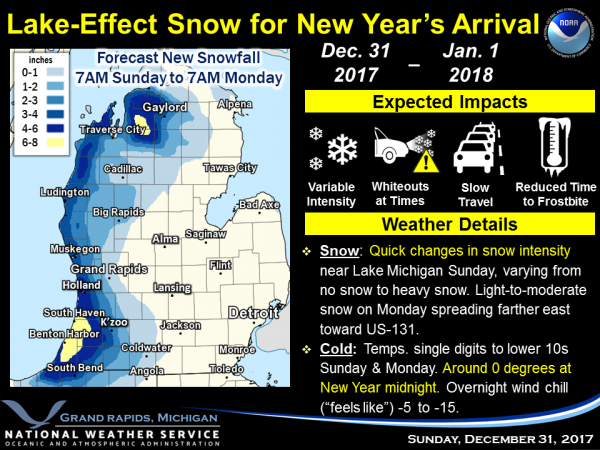
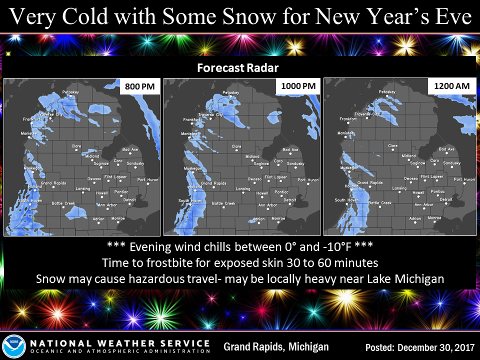
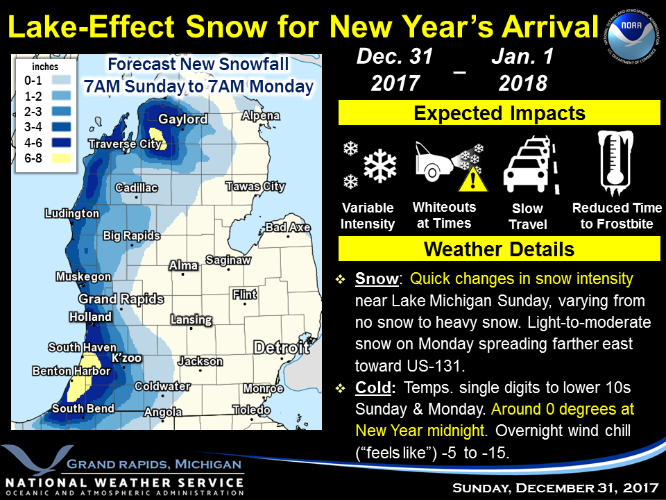
The warnings and advisories will expire at noon today. Occasional bursts of snow will affect locations near Lake Michigan on Sunday into Monday. Cold temperatures will keep roads icy or snow-covered. Wind chills below zero are expected during New Year’s Eve events. All areas in Michigan will have wind chills below zero today and tonight, so, if you are going to celebrate outside dress appropriately. Frostbite can occur in less than 30 minutes to exposed skin.
Many of us have been fortunate over the past year – I can’t help but think of those less fortunate especially those who are homeless who struggle to keep warm. My neighbor has a blanket drive every year in December and personally delivers the blankets to the homeless. Even with the extra warmth those blankets may help with holding in body temperature it is still not enough with the extreme cold we have had over the past few weeks.
When I was a Deacon in the church I saw many young mothers with their children who had no hope for a happy Christmas without the help from area churches to deliver gifts and food to their homes. It brings me cause to weep to see people in these circumstances, especially the children who are caught up in these situations.
We help these people through the holidays then they are mostly forgotten until the next Christmas season. We have many churches and organizations like Mel Trotter, Kalamazoo Deacons Conference and Christian Neighbors who need donations to help these people less fortunate than ourselves. Please keep this in mind as we celebrate the new year tonight and tomorrow. Many can’t understand what the less fortunate are going though unless we see it first hand – it is a hard life. I always keep this in mind when I feel like whining that there are those in worse situations than myself, then I consider myself blessed.
[columns] [span4]
[/span4][span4]
[/span4][span4]
[/span4][/columns]
Bands of snow showers will move onshore today leading to some hazardous travel conditions near the lakeshore. The snow showers will then persist tonight into Monday…mainly near the lakeshore with some additional accumulations possible. Very cold temperatures will persist this morning with subzero wind chills. High pressure is forecasted to dominate the weather for Tuesday…leading to a dry but very cold day for most locations.
The northwest flow picks up on the west side of the lake today…which will help to push this band onshore later this morning. Some high res models also suggest a second mesolow will eventually move onshore near South Haven later this morning or early this afternoon. We may need to extend the WSW as a result. Outside of the snow impacts…wind chills were in the -15 to -25 range earlier this morning…but have come up somewhat.
Temperatures will remain much below normal through the long range forecast period with occasional snow showers. An Alberta clipper system will move in from the northwest Tuesday night into Wednesday bringing snow followed by a reinforcing shot of arctic air for late in the week. This system will bring potential for hazardous travel conditions for the Wednesday morning commute particularly north of I-96 and then across our area Wednesday afternoon. Snow could become particularly heavy near the Lake Michigan shoreline and for areas west of US-131 due to lake enhancement and as inversion heights get a boost to near 10 kft agl Tuesday night into Wednesday.
A high pressure ridge will gradually build down from the northwest late in the week and may eventually cause snow showers to diminish somewhat inland. However lake effect/lake enhanced snow showers are likely to continue late in the week west of US-131 with potential for one or several mesolows to develop nightly due in part to nocturnal land breeze convergence. High temperatures through the long range fcst period will only reach the single digits above zero to teens. Low temperatures will range from well below zero on radiational cooling nights when a fair amount of clearing develops to near 5 to 10 above zero near Lake MI where lake effect clouds will be most persistent.
Today: A chance of snow showers before 1pm, then a chance of snow showers after 2pm. Partly sunny, with a high near 11. Wind chill values as low as -6. East southeast wind around 6 mph becoming calm in the afternoon. Chance of precipitation is 40%.
Tonight: Snow showers likely, mainly after 7pm. Mostly cloudy, with a steady temperature around 6. Wind chill values as low as -4. Calm wind becoming west northwest around 5 mph after midnight. Chance of precipitation is 60%. New snow accumulation of around an inch possible.
New Year’s Day: Snow showers likely. Mostly cloudy, with a high near 11. Wind chill values as low as -4. Light west northwest wind increasing to 5 to 10 mph in the morning. Chance of precipitation is 60%. New snow accumulation of less than one inch possible.
Monday Night: A 50 percent chance of snow showers. Mostly cloudy, with a low around 7. Wind chill values as low as -5. West wind 6 to 8 mph.
Tuesday: A 20 percent chance of snow showers before 1pm. Partly sunny, with a high near 18. West southwest wind 9 to 15 mph, with gusts as high as 23 mph.
Tuesday Night: A 30 percent chance of snow showers after 1am. Mostly cloudy, with a low around 8.
Wednesday: Snow showers likely. Cloudy, with a high near 17. Chance of precipitation is 70%.
Wednesday Night: A slight chance of snow showers. Mostly cloudy, with a low around 3.
Thursday: A slight chance of snow showers. Partly sunny and cold, with a high near 10.
Thursday Night: A chance of snow showers, mainly before 1am. Mostly cloudy, with a low around 1.
Friday: A chance of snow showers. Mostly cloudy, with a high near 11.
Friday Night: A chance of snow showers. Mostly cloudy, with a low around 3.
Saturday: A chance of snow showers. Mostly cloudy, with a high near 16.
Stay safe and warm in your celebrations tonight – most importantly have a designated driver if you are planning on being out on the roads.
Happy New Year…
GREAT news SNOW fans! The below normal temps and above normal SNOWFALL keep rockin and rollin!
http://www.cpc.ncep.noaa.gov/products/predictions/814day/814temp.new.gif
http://www.cpc.ncep.noaa.gov/products/predictions/814day/814prcp.new.gif
>>>BREAKING NEWS>>>>It will be even colder by the end of this week! Get ready!
Just put out a brand new bird feeder! Hopefully the birds will come in soon and notice it.
They’ll find it! With these very chilly temps, the finches are eating all day from the thistle feeder, a half tube a day. I buy in bulk from Family Farm & Home, as they seem to have the best price. My regular feeder is getting a lot of activity too.
Good plan, I’ll have to buy some feed in bulk too! Looking forward to see what birds we get into the feeder.
I got 2 suet feeders for Christmas- I will get them out tomorrow. I notice the birds at my neighbors place are feeding like crazy.
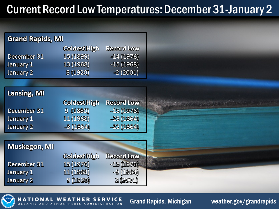
This will be one of the coldest New Year Eve and New Year days here as is the case in much of the US The record coldest maximum for today in Grand Rapids is 15° set in 1899 and that record is in play today. For New Year Day the record coldest maximum is 13° set in 1968 that may also be in play.
Here is a list of some of the coldest New Years here in Grand Rapids 2002 +1, 1974 +2, 1971 +3, 1969 -4, 1968 -15, 1964 -15, 1963 +5, 1962 +6
Slim
Here at my house I now have a temperature of +8° with light snow falling. There is 0.25” of new snow fall so far today and here at my house I have 11.3” of snow on the ground. As of yesterday, Grand Rapids has had 32.6” of snow for the month of December and is now at 33.0” for the season. (oddly similar to last year!) It has now snowed for 11 days in a row here at Grand Rapids. And in that 11 days 14.4” of snow has fallen.
Slim
Climatology for today December 31st At Grand Rapids, MI
The average H/L 31/19
The record high is 60° in 1965 the coldest maximum is 15° in 1899 (That is in play this year)
The record low is -14° in 1976 the warmest minimum is 45 in 2010
The most snow fall is 9.7” in 1957
The most on the ground is 13” in 1976
Last year the H/L was 39/28 a trace of snow fell and a trace was on the ground.
Slim
It didn’t get below zero as forecasted, thankfully. Not too bad out, actually. Got a little snow yesterday. Still have just shy of 4″ on the ground.
Both here at my house and at the Airport it got down to -7° I have just over 11″ on the ground and the GR airport reports 8″
Slim
That’s one reason why it is so challenging to accurately forecast the weather in Michigan. Temps and precipitation amounts can greatly vary over a relatively small area.
We have had the ground white now for almost a month out at thee YARDofBRICKS winter is rocking harder then the 70’s records being broke ready for more snow just the facts stay warm INDYDOG!! Happy new year MV blogger’s yeaaaa!! INDYDOG!!
Way to keep it real! Cold and SNOW definitely ROCKS!
Looking back at 2017 weather wise, the most memorable events for me would would first have to be the end of September heat wave. Temperatures flirting with 100 degrees for a sustained period of time, and spending our anniversary weekend at the Silver Lake dunes and beaches like it was mid July. Second would have to be the amount or rain and thunderstorms we had in January and February. Seemed to be more then than we had at any point during the year. And third, although not necessarily weather, the experience of seeing a total eclipse and observing the actual… Read more »
Thankfully there is no sign of any let up! Bring it on!
http://www.instantweathermaps.com/GFS-php/showmap-conussfc.php?run=2017123106&time=PER&var=ASNOWI&hour=384