Will the winter of 2023/24 be a warm and dry one?.
Here in Michigan during a strong El Nino the trend is for a warmer and dryer winter season. It also should be noted that the Atlantic Ocean surface water temperature is also warmer than average at this time.
The global weather system is complex, with many large-scale and small-scale climate influencers. A growing El Nino event will be the main driver behind the 2023/2024 Winter Season across the Northern Hemisphere. There are several oceanic regions across the world hold significance in one way or another. We can have monthly, seasonal, or decades-long anomalies in the oceans. They can sometimes tell us a small part of what is to come in the future.
There is the El Nino Southern Oscillation or ENSO. This is one of the most well-known ocean oscillations, with an especially strong influence during the Winter. It is currently in a warm (El Nino) phase. At the same time there is also a unusually warm North Atlantic Ocean. Lastly there is also a strong warm anomalies of the North Pacific Ocean. The Winter 2023/24 ocean forecast by the ECMWF, there is a strong El Niño event expanding across the entire tropical Pacific. An event of this magnitude is strong enough to have a profound atmospheric response worldwide. A stronger impact is expected in the Winter season of the Northern Hemisphere. The jet stream is a very important piece of the Winter story. During the El Niño winter season, there is typically a strong and persistent low-pressure area in the North Pacific. That pushes the polar jet stream further north, bringing warmer-than-normal temperatures to the northern United States and western Canada. This would bring colder temperatures and more snowfall across the central and parts of the southern United States, especially across the Mid-Atlantic and the northeastern United States.
We are coming off of 3 years in a row of La Nina. There has not been a string of 3 years of La Nina going back to 1950. The last moderate El Nino was in the winter of 2009/10. A winter with a cold/snowy December. January had very little snow and near average temperatures. February had near average temperatures and just a little above average snow fall. The last strong El Nino was the winter of 1991/92 That winter had a colder than average December with a little more snow than average. January was mild with less snow than average. February was warm with very little snow fall. The last very strong El Nino was in 2015/16. That year December 2015 was a record warm one with near record low snow fall. January was mild with a little less than average snowfall. And February was mild with less than average snowfall. Bottom line is that the odds favor a mild and less snow for this winter.
It was a cooler, much calmer day yesterday. The official H/L at Grand Rapids was 78/68 the sun was out just 11% of the time. A trace of rain fall was recorded at GRR. The state high yesterday was 85 at Iron Mountain and the state low was 54 at Ironwood both in the UP. For today the average H/L is 80/60 the record high of 95 was set in 1948 and 1973 the record low of 42 was set in 1945. The record rain fall amount of 2.07” fell in 1986. Last year the H/L was 78/63 and there was 0.03” of rain fall.
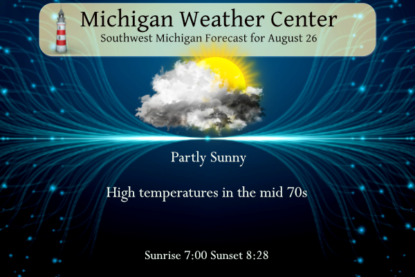
AREA FORECAST DISCUSSION
NATIONAL WEATHER SERVICE GRAND RAPIDS MI
308 AM EDT SAT AUG 26 2023
LATEST UPDATE…
SHORT TERM/LONG TERM/MARINE
SHORT TERM
(TODAY THROUGH SUNDAY)
ISSUED AT 308 AM EDT SAT AUG 26 2023
— LOW BUT PERSISTENT CHANCES FOR SHOWERS TODAY —
MOSTLY CLOUDY SKIES ARE EXPECTED AGAIN TODAY, WITH A GRADUAL DECREASE
TOWARDS EVENING. SHOWERS OVER EASTERN WISCONSIN OVERNIGHT HAVE
BEEN TRYING TO CROSS LAKE MICHIGAN WITH LIMITED SUCCESS. CURRENT
ACTIVITY NEAR MILWAUKEE HAS SOME POTENTIAL, ALBEIT SMALL, TO REACH
OUR SHORELINE AND POSSIBLY AFFECT SOME LOCATIONS SOUTH OF I-96
THIS MORNING. THUS, WE ADDED A 20 PERCENT CHANCE OF SHOWERS (80
PERCENT CHANCE OF NO SHOWERS) TO ACCOUNT FOR THIS.
THERE IS ANOTHER WEAK SIGNAL FOR PRECIPITATION EAST OF US-131
LATER THIS MORNING FOLLOWED BY ANOTHER LOW CHANCE OF SHOWERS NEAR
THE LAKESHORE THAT MAY BE RELATED TO CONVERGENCE BETWEEN NORTH-
NORTHEAST FLOW OVER LAND AND SOUTH-SOUTHWEST FLOW OVER THE LAKE.
NONE OF THIS IS HIGH CONFIDENCE NOR SHOULD BE IMPACTFUL IF IT
OCCURS.
— DRY, SUNNY, STILL COOL ON SUNDAY —
CONFIDENCE REMAINS HIGH THAT WEATHER ON SUNDAY WILL BE WORTHY OF
A STAMP OF APPROVAL FROM MOST MICHIGAN RESIDENTS. WINDS FROM THE
NORTHEAST WILL KEEP HIGH TEMPERATURES IN THE LOW 70S AND
HUMIDITIES NOTICEABLY LOWER.
LONG TERM
(SUNDAY NIGHT THROUGH FRIDAY)
ISSUED AT 308 AM EDT SAT AUG 26 2023
SPRAWLING AREA OF SFC HIGH PRESSURE KEEPS US DRY/PLEASANT THROUGH
MONDAY BEFORE A MID LEVEL SHORTWAVE IN THE NORTHWEST FLOW ALOFT AND
ASSOCIATED SFC COLD FRONT SWINGS THROUGH ON TUESDAY. HIGHEST POPS
FOR SHOWERS AND TSTMS WILL BE NORTH OF I-96 AND EAST OF HWY 131
WHERE SFC CONVERGENCE IS MAXIMIZED.
ANOTHER PUSH OF COOL/DRY AIR ARRIVES FOR MIDWEEK ON THE HEELS OF
NORTHERLY WINDS BEHIND THAT FRONT, THEN SFC AND UPR RIDGING AND DRY
WEATHER PREVAILS THROUGH THE END OF THE WEEK. EXPECT COMFORTABLE
CONDITIONS WITH LOW HUMIDITY LEVELS AND ABUNDANT SUNSHINE. A GRADUAL
MODERATION IN TEMPS WILL OCCUR LATE IN THE WEEK ONCE THE RETURN FLOW
DEVELOPS ON THE BACK SIDE OF THE SFC RIDGE, WITH NEAR TO ABOVE
NORMAL TEMPS EXPECTED BY THE TIME WE KICK OFF LABOR DAY WEEKEND.
Detailed Forecast for Grand Rapids
Overnight
A 20 percent chance of showers before 5am. Mostly cloudy, with a low around 64. Calm wind.
Saturday
Partly sunny, with a high near 75. North wind 6 to 10 mph.
Saturday Night
Mostly clear, with a low around 51. East northeast wind 7 to 11 mph.
Sunday
Sunny, with a high near 73. Northeast wind 6 to 10 mph.
Sunday Night
Clear, with a low around 51. East wind around 6 mph becoming calm in the evening.
Monday
Sunny, with a high near 75.
Monday Night
Mostly clear, with a low around 57.
Tuesday
A chance of showers. Mostly sunny, with a high near 74.
Tuesday Night
Mostly clear, with a low around 53.
Wednesday
Sunny, with a high near 72.
Wednesday Night
Clear, with a low around 49.
Detailed Forecast for Lansing
Today
A slight chance of showers between 9am and 2pm. Patchy fog before 8am. Otherwise, partly sunny, with a high near 74. North northeast wind 5 to 10 mph. Chance of precipitation is 20%.
Tonight
Mostly clear, with a low around 51. Northeast wind 8 to 13 mph.
Sunday
Sunny, with a high near 71. Northeast wind 7 to 10 mph.
Sunday Night
Mostly clear, with a low around 48. North northeast wind 5 to 8 mph becoming calm after midnight.
Monday
Sunny, with a high near 74. Calm wind becoming north 5 to 7 mph in the morning.
Monday Night
Mostly clear, with a low around 55.
Tuesday
A 40 percent chance of showers and thunderstorms after 2pm. Mostly sunny, with a high near 75.
Tuesday Night
A chance of showers and thunderstorms before 8pm. Partly cloudy, with a low around 54.
Wednesday
Sunny, with a high near 69.
Wednesday Night
Clear, with a low around 47.
Note with a chance of temperatures falling below 50 this next week that the last time it fell below 50 was June 13 at Grand Rapids, 14th at Lansing, the 17th at Holland and the 18th at Muskegon.
Fost advisorys in the upee here comes Fall yeahh!! INDY
What? Incredible!
Rest in Peace Bob Barker!!!
Many summer breaks were watching his game show…then out to play.
No way. He was the highlight of every sick day. 😢
While it needs to be updated here is some information on Michigan’s bigger tornado events.
https://www.woodtv.com/weather/preparing-for-the-big-one-michigans-worst-tornadoes/
Slim
Fun fact: We set a record for the most tornadoes (7) in a day for the month of August in the state of Michigan with this previous event. The previous record was 6 in 2018.
Here is a list of some past outbreaks in Michigan.
https://www.weather.gov/dtx/mitoroutbreaks
and this will need to be updated but here is a list of tornados in Michigan since 1951
https://data.lansingstatejournal.com/tornado-archive/
Slim
August 24, 2023 will go down in the books as a big severe weather day in Michigan history no question. I would say the damage from this event was way worse than the 2011 derecho honestly.
If anyone gets a chance to see the damage near Webberville it’s worth the trip over because it honestly is jaw dropping. The amount of trees that are gone is unreal looks like someone dropped a bomb along I-96 honestly. So sad. You can ride side streets and seen some damage I saw a house missing part of a roof. Unbelievable.
I just did that. I drove 96 east to M-52, took a right and took an immediate right on Noble Rd. Took that all the way down to Williamston Rd. Took a right, went over 96 and took a right on Linn Rd. Went all the way back to M-52 and got back on 96 west. That route encircles the entire path. Flattened crops. So many houses damaged. Countless number of trees snapped or fallen in every direction. You can clearly see where the tornado went right down the middle of 96. If I had to guess, it was at… Read more »
Yeah it is a sad sight to see. The forests in that area are forever changed. Going to be a long long time before that returns to normal.
Breaking news! Remember last winter GR saw tons of snow with multiple major storms! More of the same is coming! Get prepared now and mark it down!
https://www.foxweather.com/weather-news/farmers-almanac-winter-2023-2024
And don’t forget to the East and West of GR there was not much snow. You always leave that part out for some reason.
3rd snowiest winter in GR last year, yet the warm weather fanatics said it was an easy winter! Delusional!
Yea I feel like the debate of the 22-23 winter will never end. I-131 saw record snowfall, everyone else was dry. There done 😄
Rock on Nathan!
If anyone is going east of the capital city, it looks like I-96 has reopened.
I was able to get out of the house yesterday with the debris cleaned up so I went over to Webberville and got there about a half hour before sunset and wow the damage you see along I-96 is unreal. The tree damage is so extensive woods completely torn apart and it goes on for a long ways. Worst tree damage I’ve ever seen from a tornado in Lower Michigan.
Horrendous storm and this is why I never root for severe thunderstorms! You never know when a tornado will hit!
I have not needed to use my snowblower more than twice in each of the past four winters. The earth is getting warmer. Our winters are becoming less impactful.
Same here, our snowblower has seen very little use in recent years. I had a plow for our lawn mower but I sold it 2 weeks ago because it hasn’t been used in at least 5 years. Like Slim stated above, odds are this Winter will be another mild one.
I used my snowblower many, many times – sometimes twice in the same day! A wild snowy winter!!!
I bought a snowplow for my JD tractor last year – I got to use it several times – works better than my blower and less stress on this old body.
Get ready for multiple below normal temp days. The cool pattern continues! Incredible!
For those of you wishing for warm, dry winter, forget about it! This winter will be cold and snowy with well above normal snowfall! mark it down!