
Thanks to Slim for filling in for me last week, it was a rough one for me. It is great to have his capable hands here every day.
For those who don’t know I have had heart problems for quite some time. I collapsed last Sunday and got an ambulance ride to Borgess Hospital. I received a pacemaker/defibrillator on Monday and came back home on Tuesday. I don’t like to stay in the hospital so I was hankering to come home on Monday but they wanted to keep me another day. I have an incision in my chest where there lies an alien thing that has wires embedded in my heart to keep it beating properly. I am still sore at the incision site and my body is still trying to adjust to that and the new heart meds. Life goes on and I am back in the saddle again.
SPC Forecast
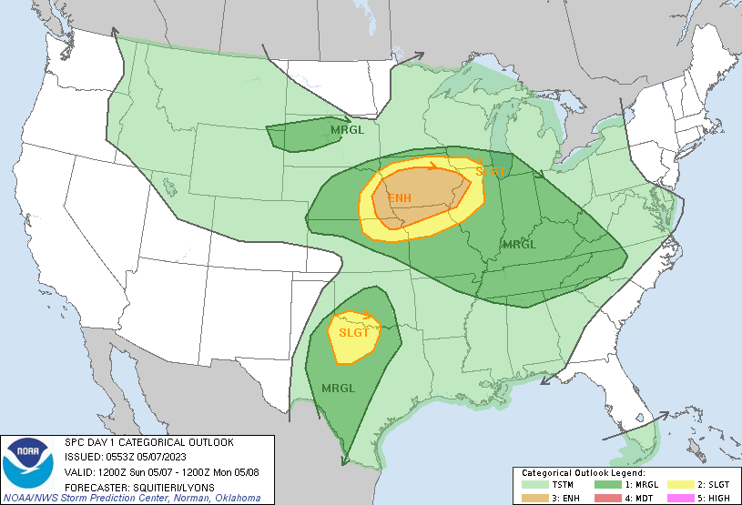
Severe storms with very large hail, hurricane-force gusts, and isolated tornadoes will be possible across parts of the Mid-Missouri Valley today. Severe wind/hail-producing storms will also be possible in parts of the central and southern Plains, perhaps extending into parts of the southern Great Lakes and Ohio Valley into the Tennessee Valley and the central Appalachians.
U.S.A and Global Events for May 7th:
1840: A powerful tornado wrecked many boats at the Natchez Landing in Mississippi and then plowed through the city on the bluff. The tornado killed 317 people and injured 109 others. The storm is currently the second deadliest tornado on record. The actual death toll could be higher as slaves were not counted.
1993: Serious flooding occurred in central Oklahoma following torrential rain and hail on this date through the 8th. Rainfall amounts on this date were generally around one inch. Oklahoma City, OK then recorded 6.64 inches of rain on the 8th, the third-greatest daily rainfall amount ever observed in the city. Extensive flooding resulted, which killed four people, and the fire department had to rescue 183 others. More than 2,000 homes and businesses were damaged or destroyed. Damages were estimated at $8 million.
1989: Thirty-two cities in the central and eastern U.S. reported record low temperatures for the date, and 24-hour snowfall totals of 7.2 inches at Buffalo and 10.7 inches at Rochester New York were records for May.
Grand Rapids Forecast
grr 5 7Forecast Discussion
- Showers and thunderstorms early this morning -

Elevated showers and storms will continue to develop through the
early morning hours. Relatively strongest storms may be capable
of producing small hail occasional lightning and brief heavy rain.
The convection is developing in response to forcing from a 35-40
kt llj and increasing moisture transport in conjunction with some
elevated instability.

00Z HREF and latest CAMs suggest convection will end by mid
morning as we lose forcing from the llj and winds begin to veer to
the west to nw. Fair wx is expected for the rest of the day.
A few showers and perhaps an isolated storm are expected tonight
through Monday with a warm front near the MI/IN border. However it
is noted that the latest HREF and guidance consensus suggests that
most convection in that time frame will stay further south across
IL/IN/OH in closer proximity to that feature.

- Fair wx for most of the upcoming week -

High pressure will build in and bring fair wx Tuesday through at
least Thursday. Large diurnal temp swings are expected with a
rather dry airmass in place. Temps will be seasonable for this
time of year early next week before moderating to around 5-10
degrees above normal mid to late week. Fire wx concerns may
increase a bit by midweek with mild temps and low rh values.
Those concerns will be largely contingent on how strong the winds
are daily.
80 here and I should’ve used sunblock. Pressure washed the back deck. Mowed the lawn. Brought out the deck furniture and did some odds and ends. After that brief cool stretch recently, it feels very warm out.
Was out doing some more yard work. The sun is now out and for the first time this year I can say it is warm and somewhat humid out. The current temperature here in MBY is 78 and I have a DP of 66.
Slim
I love it! Great weather!
Glad to have you back MV. I am sure your wife is keeping good tabs in you. Not too much stress or whatever the Dr has placed on you. Hugs to your wife!!
Woke up a few different times to some thunder this morning.
Have a nice Sunday everyone!
I heard some distant thunder this morning. Only a few sprinkles here. Good thin ‘cause I need to mow again. I’m needing to mow every four days or so.
Yes, it is great to have you back and on the weather front (bad joke)! I also have a (minor) congenital issue with my ticker. I asked the doctor a few years ago if I was a candidate for a pace maker, but he told me I didn’t have the heart for it (another bad joke).
Welcome back, Michael. You were missed and always on our minds.
I posted this yesterday but I will toss it up one more time. This is from national weather blog and one of the posters on that blog had this to say about the upcoming summer season. “The Euro Seasonal came in this week and when I first glanced at it I said to myself “Who was it that said…Year without a Summer?” If anyone lives near the GL’s, I’m concerned that “real summer” like we have had the past few seasons don’t look likely this year. Nearly every global model is depicting a trough centered over this region and the… Read more »
I like your caveat at the end – don’t shoot the messenger!
Only the Lord knows how this summer will play out. Then again the Lansing NWS station had what, some 14 consecutive months with above average temps? Climate change aside, to say we overdue for a legit cool pattern is an understatement.
Yesterday the official H/L was 69/50. There was 0.03” of rain fall and just 6% of possible sunshine. The overnight low here in MBY was 56 and I recorded 0.17” of rain fall up to 7AM The current temperature is 57 here in my yard. For today the average H/L is now up to 67/45 the record high of 89 was set in 1965 and the record low of 25 was set in 1974. The record rain fall of 1.70” fell in 1932.
Slim
I was honored to fill in for MV.
Slim
Get ready – the last half of May will feature below normal temps despite the warm weather hype! Wow, just wow!
Currently the next two weeks look to be warmer than average. Then according to the CFSv2 turning to below to near average in weeks 3 and 4. Even with the rain in this weeks forecast the CFSv2 has the Great Lakes area on the dry side.
https://www.cpc.ncep.noaa.gov/products/people/mchen/CFSv2FCST/weekly/
Slim
Welcome Back!
Severe Thunderstorm Warning for Allegan and Barry County for quarter size hail.
yup, we had some hail and a quarter inch of rain from the storm which passed through
Great to see you back MV!